$1,995
/ Month
339 36th St SE
Washington, DC 20019
Today
Favorites
301-686-5670
-
Bedrooms
2
-
Bathrooms
1
-
Square Feet
832 sq ft
-
Available
Available Now
339 36th St SE

Favorites
About This Home
$1,995 deposit,
Available Now
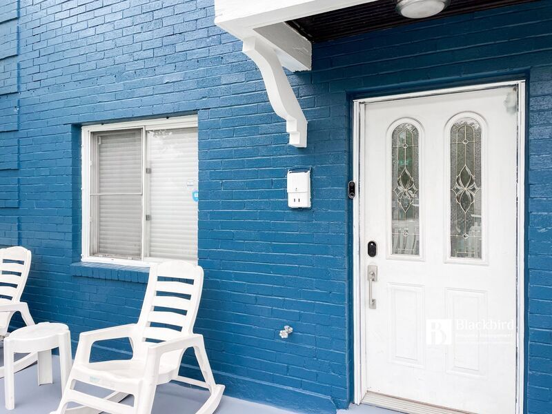
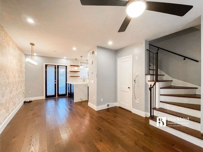
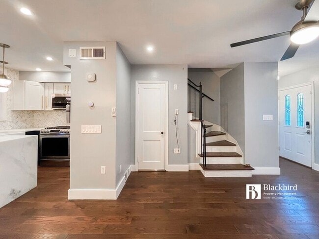
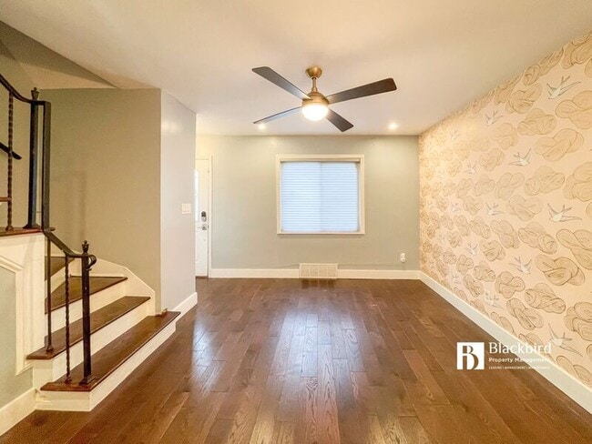
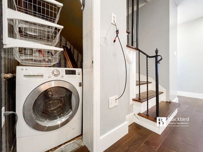
Presenting an exquisite 2-bed, 1-bath residence brought to you by Tony Williams and Blackbird Property Management. Nestled in a serene residential enclave, this home is a true gem, perfectly situated next to a park. Convenience abounds, with mere steps to the H St. Corridor, Streetcar stop, Union Market, Langston Golf Course, Metro stations, major thoroughfares, and more. Additionally, you'll enjoy easy access to Benning Road for a swift commute downtown or to I-295. This home boasts a myriad of high-end upgrades, featuring custom cabinets, automated remote blinds, stainless steel appliances, stylish lighting fixtures, an in-unit washer/dryer, a pristine bathroom, and a spacious private backyard. Water is included, adding to the overall appeal. Don't miss this opportunity to make this remarkable property your own. Please note: The landlord requires a minimum credit score of 640 for all applicants.
339 36th St SE is a townhome located in District of Columbia County and the 20019 ZIP Code. This area is served by the District Of Columbia Public Schools attendance zone.
* Price shown is base rent and may not include non-optional fees and utilities. Price, availability, fees, and any applicable rent special are subject to change without notice.
* Square footage definitions vary. Displayed square footage is approximate.
Fees and Policies
The fees below are based on community-supplied data and may exclude additional fees and utilities.
- Dogs Allowed
-
Fees not specified
- Cats Allowed
-
Fees not specified
Contact
- Phone Number
- Contact
Location
Get Directions
The residential neighborhood of Fort Dupont sits just east of the Anacostia River in Southeast Washington, DC. The neighborhood has ample green space provided by two adjacent parks — Fort Circle Park and Fort Chaplin Park — and distinguishes itself within the Greater Anacostia area by housing the only public indoor ice rink in Washington, DC.
There’s a diverse mix of rentals in Fort Dupont, from more recent and upscale developments to long-standing apartment homes closer to the Anacostia River. Proximity to the Benning Road Metro Station makes Fort Dupont perfect for the Capitol Hill commuter who wishes to reside outside the bustle of DC.
Learn more about living in Fort Dupont
Education
| Colleges & Universities | Distance | ||
|---|---|---|---|
| Colleges & Universities | Distance | ||
| Drive: | 8 min | 3.6 mi | |
| Drive: | 8 min | 4.5 mi | |
| Drive: | 8 min | 4.5 mi | |
| Drive: | 9 min | 5.0 mi |
339 36th St SE is within 8 minutes or 3.6 miles from Gallaudet University. It is also near Georgetown and Georgetown Law.
Schools


Public Elementary School
Grades PK-5
395 Students
Attendance Zone
Public Middle School
Grades 6-8
215 Students
Attendance Zone
Public High School
Grades 9-12
287 Students
Attendance Zone
Private Elementary, Middle & High School
Grades PK-12
149 Students
Nearby
School data provided by
 The GreatSchools Rating helps parents compare schools within a state based on a variety of school quality indicators and provides a helpful picture of how effectively each school serves all of its students. Ratings are on a scale of 1 (below average) to 10 (above average) and can include test scores, college readiness, academic progress, advanced courses, equity, discipline and attendance data. We also advise parents to visit schools, consider other information on school performance and programs, and consider family needs as part of the school selection process.
View GreatSchools Rating Methodology
Data provided by GreatSchools.org © 2025. All rights reserved.
View GreatSchools Rating Methodology
Data provided by GreatSchools.org © 2025. All rights reserved.
Transportation options available in Washington include Benning Road, located 1.2 miles from 339 36th St SE. 339 36th St SE is near Ronald Reagan Washington Ntl, located 8.5 miles or 17 minutes away, and Baltimore/Washington International Thurgood Marshall, located 28.6 miles or 42 minutes away.
| Transit / Subway | Distance | ||
|---|---|---|---|
| Transit / Subway | Distance | ||
|
|
Drive: | 2 min | 1.2 mi |
|
|
Drive: | 3 min | 1.3 mi |
| Drive: | 3 min | 1.8 mi | |
|
|
Drive: | 5 min | 2.3 mi |
| Drive: | 4 min | 2.3 mi |
| Commuter Rail | Distance | ||
|---|---|---|---|
| Commuter Rail | Distance | ||
|
|
Drive: | 7 min | 3.9 mi |
|
|
Drive: | 8 min | 4.0 mi |
|
|
Drive: | 9 min | 4.4 mi |
|
|
Drive: | 9 min | 4.4 mi |
|
|
Drive: | 13 min | 7.1 mi |
| Airports | Distance | ||
|---|---|---|---|
| Airports | Distance | ||
|
Ronald Reagan Washington Ntl
|
Drive: | 17 min | 8.5 mi |
|
Baltimore/Washington International Thurgood Marshall
|
Drive: | 42 min | 28.6 mi |
Time and distance from 339 36th St SE.
| Shopping Centers | Distance | ||
|---|---|---|---|
| Shopping Centers | Distance | ||
| Walk: | 11 min | 0.6 mi | |
| Walk: | 14 min | 0.7 mi | |
| Drive: | 2 min | 1.2 mi |
339 36th St SE has 3 shopping centers within 1.2 miles, which is about a 2-minute walk. The miles and minutes will be for the farthest away property.
| Parks and Recreation | Distance | ||
|---|---|---|---|
| Parks and Recreation | Distance | ||
|
Fort Dupont Park
|
Drive: | 3 min | 1.4 mi |
|
Kingman and Heritage Island Park
|
Drive: | 3 min | 1.8 mi |
|
Frederick Douglass National Historic Site
|
Drive: | 7 min | 2.6 mi |
|
Washington Youth Garden
|
Drive: | 6 min | 3.3 mi |
|
National Arboretum
|
Drive: | 10 min | 4.1 mi |
339 36th St SE has 5 parks within 4.1 miles, including Fort Dupont Park, Kingman and Heritage Island Park, and Frederick Douglass National Historic Site.
| Hospitals | Distance | ||
|---|---|---|---|
| Hospitals | Distance | ||
| Drive: | 11 min | 4.3 mi | |
| Drive: | 11 min | 4.8 mi | |
| Drive: | 10 min | 5.0 mi |
339 36th St SE has 3 hospitals within 5.0 miles, the nearest is St. Elizabeth's Hospital which is 4.3 miles away and a 11 minute drive.
| Military Bases | Distance | ||
|---|---|---|---|
| Military Bases | Distance | ||
| Drive: | 8 min | 3.3 mi | |
| Drive: | 13 min | 4.5 mi |
339 36th St SE is 3.3 miles from Washington Navy Yard, and is convenient to other military bases, including Fort McNair.
You May Also Like
Similar Rentals Nearby


What Are Walk Score®, Transit Score®, and Bike Score® Ratings?
Walk Score® measures the walkability of any address. Transit Score® measures access to public transit. Bike Score® measures the bikeability of any address.
What is a Sound Score Rating?
A Sound Score Rating aggregates noise caused by vehicle traffic, airplane traffic and local sources

339 36th St SE
Washington, DC 20019