$2,000
/ Month
32 W 1700 S
Salt Lake City, UT 84115
Today
|
Edit
Favorites
-
Bedrooms
2
-
Bathrooms
2
-
Square Feet
--
-
Available
Available Now
32 W 1700 S

Favorites
About This Home
Available Now
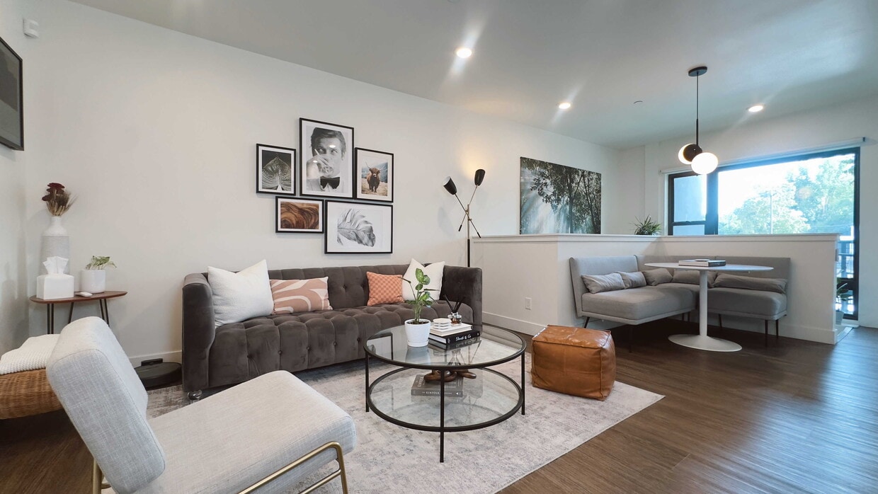
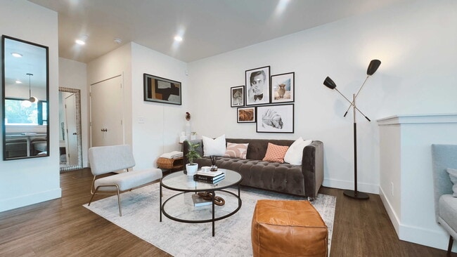
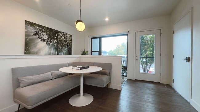
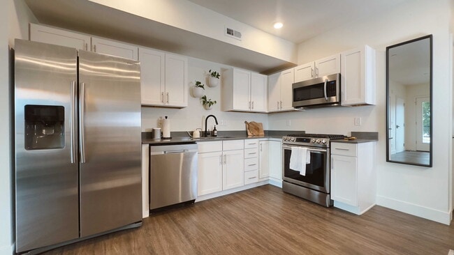
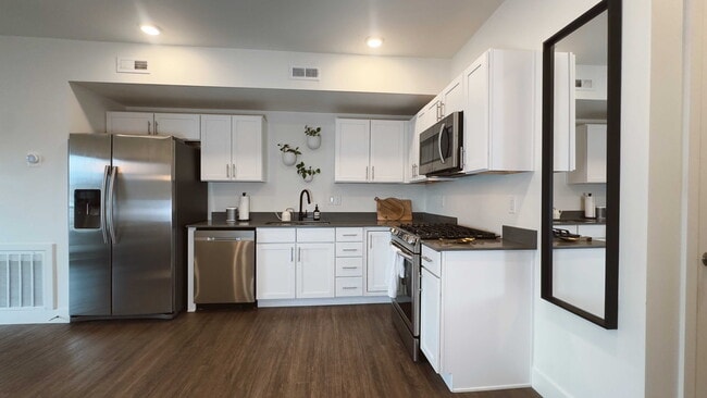
This home can be offered furnished or unfurnished - furnishings can be removed upon request.Experience city living in this modern, townhome-style condo designed with traveling professionals in mind, offering a truly move-in-ready option in the heart of Salt Lake City. The bright, sun-filled space features sleek finishes, a chef’s kitchen with quartz countertops and stainless steel appliances, a cozy dining nook, and a spacious primary suite with a queen Purple mattress and private bath.Enjoy fast Wi-Fi, in-unit laundry, a Samsung Frame TV, a private balcony, secure keypad entry, and an attached covered carport with EV charging. Located just minutes from downtown, major hospitals, and the University of Utah with TRAX nearby, this unbeatable location sits across from Sweet Lake Biscuits & Limeade and near Liberty Park, boutiques, local coffee shops, and restaurants.A perfect blend of modern comfort, flexibility, and urban convenience.
32 W 1700 S is a townhome located in Salt Lake County and the 84115 ZIP Code. This area is served by the Salt Lake District attendance zone.
* Price shown is base rent. Excludes user-selected optional fees and variable or usage-based fees and required charges due at or prior to move-in or at move-out. Price, availability, fees, and any applicable rent special are subject to change without notice.
* Square footage definitions vary. Displayed square footage is approximate.
Townhome Features
- Microwave
Contact
- Listed by Sara Tovar
- Contact
Location
Get Directions
Amenities
- Microwave
Situated between Interstate 15 and Highway 89, People’s Freeway is a park-like area home to quirky attractions. Catch a Salt Lake Bees game at Smith’s Ballpark, located off Main Street, or head a bit north of the neighborhood to Brewvies Cinema Pub, a movie theater serving local beers. Other excitement within the area includes a rock-climbing gym, a haunted house, and community parks. People’s Freeway is also known for its great food and shopping options. Restaurants serving everything from biscuits and limeade to dim sum are located throughout town. Retail centers equipped with a variety of businesses and stores round out the commercial developments. The rest of People’s Freeway is made up residential areas with a variety of apartments for rent.
Learn more about living in People's Freeway
Education
| Colleges & Universities | Distance | ||
|---|---|---|---|
| Colleges & Universities | Distance | ||
| Drive: | 6 min | 2.0 mi | |
| Drive: | 11 min | 4.7 mi | |
| Drive: | 13 min | 5.3 mi | |
| Drive: | 14 min | 6.9 mi |
32 W 1700 S is within 6 minutes or 2.0 miles from Westminster College. It is also near The University of Utah and The Univ. of Utah, Ft Douglas.
Schools


Public Elementary School
Grades PK-6
499 Students
Attendance Zone
Public Elementary & Middle School
Grades K-8
Attendance Zone
Public Middle School
Grades 7-8
555 Students
Attendance Zone
Public High School
Grades 9-12
1,980 Students
Attendance Zone
Public High School
Grades 9-12
293 Students
Attendance Zone
Private Elementary & Middle School
Grades PK-8
Nearby
Private Middle & High School
Grades 6-12
31 Students
Nearby
School data provided by
 The GreatSchools Rating helps parents compare schools within a state based on a variety of school quality indicators and provides a helpful picture of how effectively each school serves all of its students. Ratings are on a scale of 1 (below average) to 10 (above average) and can include test scores, college readiness, academic progress, advanced courses, equity, discipline and attendance data. We also advise parents to visit schools, consider other information on school performance and programs, and consider family needs as part of the school selection process.
View GreatSchools Rating Methodology
Data provided by GreatSchools.org © 2025. All rights reserved.
View GreatSchools Rating Methodology
Data provided by GreatSchools.org © 2025. All rights reserved.
Transportation options available in Salt Lake City include Ballpark, located 0.8 mile from 32 W 1700 S. 32 W 1700 S is near Salt Lake City International, located 7.9 miles or 13 minutes away.
| Transit / Subway | Distance | ||
|---|---|---|---|
| Transit / Subway | Distance | ||
|
|
Walk: | 16 min | 0.8 mi |
|
|
Walk: | 17 min | 0.9 mi |
|
|
Walk: | 17 min | 0.9 mi |
|
|
Drive: | 3 min | 1.3 mi |
|
|
Drive: | 4 min | 1.7 mi |
| Commuter Rail | Distance | ||
|---|---|---|---|
| Commuter Rail | Distance | ||
|
|
Drive: | 9 min | 3.4 mi |
|
|
Drive: | 10 min | 5.3 mi |
|
|
Drive: | 16 min | 12.3 mi |
|
|
Drive: | 18 min | 13.7 mi |
|
|
Drive: | 24 min | 17.1 mi |
| Airports | Distance | ||
|---|---|---|---|
| Airports | Distance | ||
|
Salt Lake City International
|
Drive: | 13 min | 7.9 mi |
Time and distance from 32 W 1700 S.
| Shopping Centers | Distance | ||
|---|---|---|---|
| Shopping Centers | Distance | ||
| Walk: | 10 min | 0.5 mi | |
| Walk: | 13 min | 0.7 mi | |
| Walk: | 13 min | 0.7 mi |
32 W 1700 S has 3 shopping centers within 0.7 mile, which is about a 13-minute walk. The miles and minutes will be for the farthest away property.
| Parks and Recreation | Distance | ||
|---|---|---|---|
| Parks and Recreation | Distance | ||
|
Liberty Park
|
Drive: | 5 min | 2.1 mi |
|
Mormon Pioneer National Historic Trail
|
Drive: | 6 min | 2.3 mi |
|
California National Historic Trail
|
Drive: | 6 min | 2.3 mi |
|
International Peace Gardens
|
Drive: | 5 min | 2.4 mi |
|
Tracy Aviary
|
Drive: | 7 min | 2.7 mi |
32 W 1700 S has 5 parks within 2.7 miles, including Tracy Aviary, Liberty Park, and California National Historic Trail.
| Hospitals | Distance | ||
|---|---|---|---|
| Hospitals | Distance | ||
| Drive: | 3 min | 1.2 mi | |
| Drive: | 9 min | 3.7 mi | |
| Drive: | 9 min | 4.1 mi |
32 W 1700 S has 3 hospitals within 4.1 miles, the nearest is Marian Center which is 1.2 miles away and a 3 minute drive.
| Military Bases | Distance | ||
|---|---|---|---|
| Military Bases | Distance | ||
| Drive: | 10 min | 6.2 mi |
32 W 1700 S is 6.2 miles and a 10 minute drive from Salt Lake City Airport Air Guard Station.
You May Also Like
Similar Rentals Nearby


What Are Walk Score®, Transit Score®, and Bike Score® Ratings?
Walk Score® measures the walkability of any address. Transit Score® measures access to public transit. Bike Score® measures the bikeability of any address.
What is a Sound Score Rating?
A Sound Score Rating aggregates noise caused by vehicle traffic, airplane traffic and local sources

32 W 1700 S
Salt Lake City, UT 84115