
$3,200 - $5,600
Total Monthly Price
28 Fleet St
Boston, MA 02113
2 Weeks Ago
|
Edit
Favorites
-
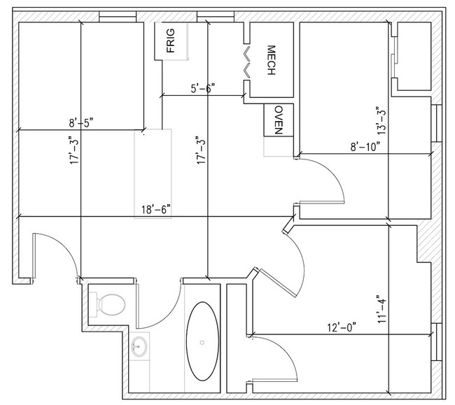
Bedrooms
2 - 3
-
Bathrooms
1 - 2
-
Square Feet
555 - 654 sq ft
Highlights
- Pool
- Hardwood Floors
- Waterfront
28 Fleet St

Favorites
2 Available Units
14
$3,200
Total Monthly Price
2 beds,
1 bath,
654 sq ft
15 Month Lease, $3,200 deposit,
Available Now
A
$5,600
Total Monthly Price
3 beds,
2 baths,
555 sq ft
12 Month Lease, $5,600 deposit,
Available Now
* Price shown is base rent. Excludes user-selected optional fees and variable or usage-based fees and required charges due at or prior to move-in or at move-out.
Price, availability, fees, and any applicable rent special are subject to change without notice.
* Square footage definitions vary. Displayed square footage is approximate.
About 28 Fleet St Boston, MA 02113
15 Month Lease,
$3,200 deposit
Bus: 93 N Washington St @ Medford St (0.31 mi) Bus: 15 Cambridge St @ Center Plaza - Gov't Ctr (0.51 mi) Bus: 4 Commercial St @ Fleet St (0.09 mi) Bus: 352 New Sudbury @ Congress St (0.34 mi) Subway: Orange Line Haymarket (0.31 mi) Subway: Blue Line Aquarium (0.33 mi) Ferry: Charlestown Ferry Long Wharf (South) (0.37 mi) Tram: D Haymarket (0.31 mi) Ferry: Hingham/Hull Ferry Long Wharf (North) (0.29 mi) Bus: 117 Haymarket (0.30 mi) Bus: 89/93 N Washington St @ Thacher St (0.29 mi) Rail: Fitchburg Line North Station (0.51 mi) The North End, Boston’s Little Italy, is a maze of narrow streets with some of the city’s oldest buildings. On the self-guided Freedom Trail, tourists pass historic sites like the 1680 Paul Revere House and the Old North Church, which played a key role at the beginning of the Revolutionary War. Italian restaurants, coffeehouses, pastry shops and old-school delis pack the area, especially on lively Hanover Street. Boston and its North End offer a veritable surfeit of historical sites and stories! Each epoch has left an indelible impact on commerce, customs, religious traditions, politics and institutions – in sum – upon the very city and neighborhoods that we know today. The heart of the Freedom Trail is in the North End neighborhood and walked by 3.2 million visitors each year. The historic walking path was organized in 1951 when 16 sites were “linked” to better tell Boston’s story of the American Revolution. Overseen by The Freedom Trail Foundation, the distinctive red line weaves through 2.5 miles of downtown Boston. In the North End, heading north, the Freedom Trail comes from Haymarket and Blackstone Street through the Greenway parks to Cross Street. The path then heads down Hanover Street, taking a short detour through North Square to pass the Paul Revere House before returning to Hanover Street. At St. Stephen’s Church, the path turns into the Prado – Paul Revere Mall park past Cyrus E. Dallin’s famous equestrian statue of Paul Revere to the Old North Church on Salem Street. From Old North, the trail heads up Hull Street to Copp’s Hill Burying Ground before heading out of the North End toward Charlestown. The Harborwalk is a free public walkway along the waterfront with parks, public art, seating areas, cafes, exhibit areas, interpretive signage, water transportation facilities and a wide range of other amenities. In 1984, the Boston Redevelopment Authority joined in partnership with the Harborpark Advisory Committee and The Boston Harbor Association to initiate Harborpark focus on the revitalization of Boston’s waterfront. When completed, the HarborWalk will stretch some 46.9 linear miles along wharves, piers, bridges, beaches and shoreline from Chelsea Creek to the Neponset River. In the North End, the Harborwalk is largely completed and among the most well-maintained and highly visited in the city. It encompasses the wharves along Boston Harbor (Battery Wharf, Burroughs Wharf, Lincoln Wharf, Union Wharf, Lewis Wharf, Sargent’s Wharf, Constellation Wharf, Commercial Wharf, Long Wharf, Central Wharf, India Wharf and Rowes Wharf) and several parks including Puopolo Park, Langone Park and Christopher Columbus Park. It also includes Mirabella Pool, Steriti Memorial Skating Rink and the New England Aquarium. The Coast Guard Base Harborwalk has recently re-opened through an entrance adjacent to Mirabella Pool and includes a circular sitting area and wooden pier, open from May through November. A pocket museum can also be found at the recently completed Battery Wharf. This information was sourced from BostonHarborwalk
2 bed 1 bath, Fleet Street in the North End! Enough Said! "THE NORTH END!" Laundry in Building
28 Fleet St is an apartment community located in Suffolk County and the 02113 ZIP Code.
* Price shown is total price based on community-supplied monthly required fees. Excludes user-selected optional fees and variable or usage-based fees and required charges due at or prior to move-in or at move-out. Price, availability, fees, and any applicable rent special are subject to change without notice.
* Square footage definitions vary. Displayed square footage is approximate.
Apartment Features
Dishwasher
Hardwood Floors
Granite Countertops
Refrigerator
- Heating
- Cable Ready
- Dishwasher
- Disposal
- Granite Countertops
- Eat-in Kitchen
- Kitchen
- Range
- Refrigerator
- Hardwood Floors
- Office
- Crown Molding
- Views
- Laundry Facilities
- Pool
- Waterfront
Fees and Policies
The fees below are based on community-supplied data and may exclude additional fees and utilities.
Details
Utilities Included
-
Water
-
Trash Removal
-
Sewer
Lease Options
-
12 - 15 Month Leases
Property Information
-
8 units
Contact
- Listed by Jan Marchant
Location
Get Directions
The North End of Boston occupies the northeastern corner of the city beyond Washington Street and Columbus Circle. It is the city’s oldest residential neighborhood and comes with a rich history. Boston’s “Little Italy” has undergone some serious growth and modernization over the decades. Once home to revolutionary heroes such as Paul Revere, the area now draws new residents, young professionals, retirees, and tourists. Residents’ pride in this neighborhood is almost tangible – locals love North End and show it every summer during Feast season, a few weeks span of parades, music, dancing, and street food, all in celebration of North End and historic Italian Saints.
While this neighborhood is admittedly very tourist-heavy, the resulting revenue keeps the economy booming. Residents are still able to live, work, and play like normal. North End is less than a mile from Downtown Boston, making work commutes a breeze.
Learn more about living in North End Boston
Education
| Colleges & Universities | Distance | ||
|---|---|---|---|
| Colleges & Universities | Distance | ||
| Walk: | 13 min | 0.7 mi | |
| Drive: | 5 min | 1.5 mi | |
| Drive: | 5 min | 1.6 mi | |
| Drive: | 6 min | 2.6 mi |
28 Fleet St is within 13 minutes or 0.7 mile from Suffolk University. It is also near Emerson College and Tufts University, Boston.
Transportation options available in Boston include Haymarket Station, located 0.4 mile from 28 Fleet St. 28 Fleet St is near General Edward Lawrence Logan International, located 3.7 miles or 9 minutes away.
| Transit / Subway | Distance | ||
|---|---|---|---|
| Transit / Subway | Distance | ||
|
|
Walk: | 7 min | 0.4 mi |
|
|
Walk: | 8 min | 0.4 mi |
|
|
Walk: | 9 min | 0.5 mi |
|
|
Walk: | 11 min | 0.6 mi |
|
|
Walk: | 11 min | 0.6 mi |
| Commuter Rail | Distance | ||
|---|---|---|---|
| Commuter Rail | Distance | ||
|
|
Walk: | 12 min | 0.7 mi |
|
|
Drive: | 3 min | 1.1 mi |
|
|
Drive: | 9 min | 2.3 mi |
| Drive: | 8 min | 3.3 mi | |
| Drive: | 9 min | 4.0 mi |
| Airports | Distance | ||
|---|---|---|---|
| Airports | Distance | ||
|
General Edward Lawrence Logan International
|
Drive: | 9 min | 3.7 mi |
Time and distance from 28 Fleet St.
| Shopping Centers | Distance | ||
|---|---|---|---|
| Shopping Centers | Distance | ||
| Walk: | 7 min | 0.4 mi | |
| Walk: | 8 min | 0.4 mi | |
| Walk: | 10 min | 0.6 mi |
28 Fleet St has 3 shopping centers within 0.6 mile, which is about a 10-minute walk. The miles and minutes will be for the farthest away property.
| Parks and Recreation | Distance | ||
|---|---|---|---|
| Parks and Recreation | Distance | ||
|
Boston National Historical Park
|
Walk: | 8 min | 0.4 mi |
|
New England Aquarium
|
Walk: | 11 min | 0.6 mi |
|
Boston Harbor Islands National Recreation Area
|
Drive: | 3 min | 1.1 mi |
|
Boston Children's Museum
|
Drive: | 4 min | 1.2 mi |
|
Boston African American National Historic Site
|
Drive: | 4 min | 1.2 mi |
28 Fleet St has 5 parks within 1.2 miles, including Boston National Historical Park, New England Aquarium, and Boston Harbor Islands National Recreation Area.
| Hospitals | Distance | ||
|---|---|---|---|
| Hospitals | Distance | ||
| Drive: | 4 min | 1.2 mi | |
| Drive: | 4 min | 1.3 mi | |
| Drive: | 4 min | 1.4 mi |
28 Fleet St has 3 hospitals within 1.4 miles, the nearest is Shriners Hospital for Children - Boston which is 1.2 miles away and a 4 minute drive.
| Military Bases | Distance | ||
|---|---|---|---|
| Military Bases | Distance | ||
| Drive: | 31 min | 16.2 mi | |
| Drive: | 32 min | 18.7 mi |
28 Fleet St is 16.2 miles from Hanscom Air Force Base, and is convenient to other military bases, including Fort Miller.
Amenities
- Heating
- Cable Ready
- Dishwasher
- Disposal
- Granite Countertops
- Eat-in Kitchen
- Kitchen
- Range
- Refrigerator
- Hardwood Floors
- Office
- Crown Molding
- Views
- Laundry Facilities
- Waterfront
- Pool
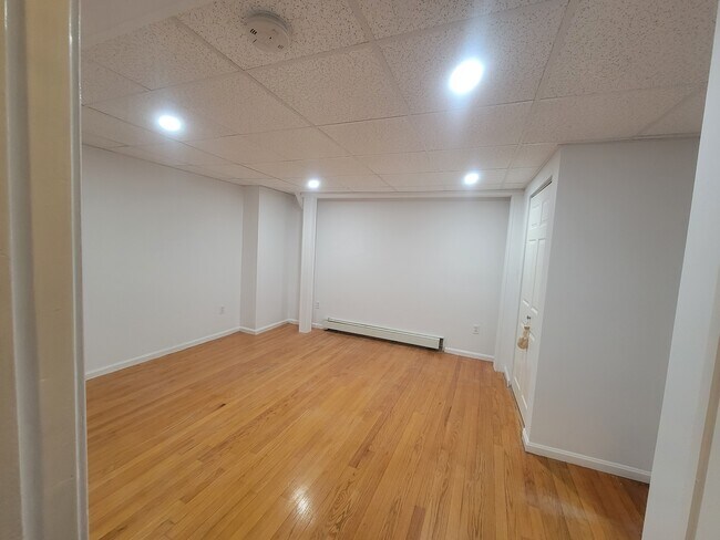
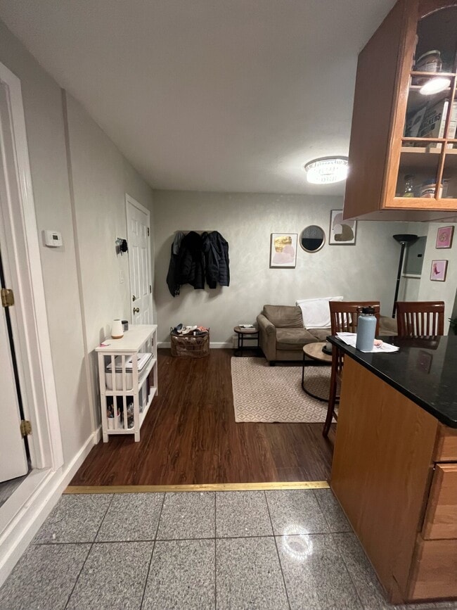
28 Fleet St Photos
What Are Walk Score®, Transit Score®, and Bike Score® Ratings?
Walk Score® measures the walkability of any address. Transit Score® measures access to public transit. Bike Score® measures the bikeability of any address.
What is a Sound Score Rating?
A Sound Score Rating aggregates noise caused by vehicle traffic, airplane traffic and local sources

28 Fleet St
Boston, MA 02113