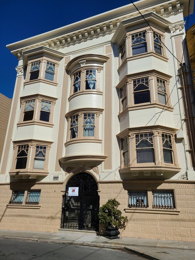
27 Linda St
27 Linda St,
San Francisco,
CA
94110
2 Weeks Ago
Favorites
27 Linda St

Favorites
Check Back Soon for Upcoming Availability
Fees and Policies
The fees below are based on community-supplied data and may exclude additional fees and utilities.
- Cats Allowed
-
Fees not specified
-
Weight limit--
-
Pet Limit--
- Parking
-
Street--
Details
Utilities Included
-
Water
-
Trash Removal
Property Information
-
6 units
Location
Get Directions
Lively, upbeat and casual, Mission Dolores captures the spirit of diversity that represents the heart of San Francisco culture. Located in the north central portion of San Francisco at the crossroads of Noe Valley, the Castro District, and Haight-Ashbury, Mission Dolores streets buzz with activity all day and well into the night. Mission Dolores is wedged between Dolores Heights and the Mission District. The neighborhood wraps around and is named for the Mision San Francisco de Asis. or Mission Dolores. This historic mission was founded in 1776. The current mission building replaced the earlier log building and was built in 1791, making it the oldest building in San Francisco.
Mission Dolores has become one of San Francisco's hippest neighborhoods in a city known for its unique, trendy communities. Here, old Victorians with tiny, well-tended yards dot steep, tree-lined streets, and small wine and tapas bars dot the landscape.
Learn more about living in Mission DoloresBelow are rent ranges for similar nearby apartments
Expenses
Utilities Included
Water, Trash Removal
Included
Education
| Colleges & Universities | Distance | ||
|---|---|---|---|
| Colleges & Universities | Distance | ||
| Drive: | 5 min | 1.9 mi | |
| Drive: | 6 min | 2.3 mi | |
| Drive: | 8 min | 2.6 mi | |
| Drive: | 8 min | 3.2 mi |
27 Linda St is within 5 minutes or 1.9 miles from California College of the Arts. It is also near UC San Francisco, Mission Bay and UC San Francisco, Mount Zion.
Transportation options available in San Francisco include Right Of Way/18Th St, located 0.3 mile from 27 Linda St. 27 Linda St is near San Francisco International, located 12.6 miles or 22 minutes away, and Metro Oakland International, located 21.2 miles or 33 minutes away.
| Transit / Subway | Distance | ||
|---|---|---|---|
| Transit / Subway | Distance | ||
| Walk: | 6 min | 0.3 mi | |
| Walk: | 6 min | 0.3 mi | |
|
|
Walk: | 8 min | 0.4 mi |
|
|
Walk: | 8 min | 0.4 mi |
|
|
Walk: | 8 min | 0.4 mi |
| Commuter Rail | Distance | ||
|---|---|---|---|
| Commuter Rail | Distance | ||
| Drive: | 6 min | 2.7 mi | |
| Drive: | 6 min | 2.7 mi | |
| Drive: | 6 min | 2.8 mi | |
| Drive: | 6 min | 2.8 mi | |
| Drive: | 11 min | 4.7 mi |
| Airports | Distance | ||
|---|---|---|---|
| Airports | Distance | ||
|
San Francisco International
|
Drive: | 22 min | 12.6 mi |
|
Metro Oakland International
|
Drive: | 33 min | 21.2 mi |
Time and distance from 27 Linda St.
| Shopping Centers | Distance | ||
|---|---|---|---|
| Shopping Centers | Distance | ||
| Walk: | 15 min | 0.8 mi | |
| Drive: | 4 min | 1.2 mi | |
| Drive: | 3 min | 1.3 mi |
27 Linda St has 3 shopping centers within 1.3 miles, which is about a 3-minute walk. The miles and minutes will be for the farthest away property.
| Parks and Recreation | Distance | ||
|---|---|---|---|
| Parks and Recreation | Distance | ||
|
Buena Vista Park
|
Drive: | 5 min | 1.7 mi |
|
Randall Museum
|
Drive: | 6 min | 1.9 mi |
|
Children's Creativity Museum
|
Drive: | 6 min | 2.5 mi |
|
Conservatory of Flowers
|
Drive: | 7 min | 3.1 mi |
|
California Academy of Sciences
|
Drive: | 10 min | 3.8 mi |
27 Linda St has 5 parks within 3.8 miles, including Randall Museum, Buena Vista Park, and Children's Creativity Museum.
| Hospitals | Distance | ||
|---|---|---|---|
| Hospitals | Distance | ||
| Walk: | 20 min | 1.0 mi | |
| Drive: | 5 min | 1.3 mi | |
| Drive: | 4 min | 1.5 mi |
27 Linda St has 3 hospitals within 1.5 miles, the nearest is California Pacific Medical Center - Mission Bernal which is 1.0 miles away and a 20 minute walk.
| Military Bases | Distance | ||
|---|---|---|---|
| Military Bases | Distance | ||
| Drive: | 16 min | 5.9 mi | |
| Drive: | 16 min | 6.5 mi |
27 Linda St is 5.9 miles from East Fort Miley, and is convenient to other military bases, including West Fort Miley.
You May Also Like
Similar Rentals Nearby


What Are Walk Score®, Transit Score®, and Bike Score® Ratings?
Walk Score® measures the walkability of any address. Transit Score® measures access to public transit. Bike Score® measures the bikeability of any address.
What is a Sound Score Rating?
A Sound Score Rating aggregates noise caused by vehicle traffic, airplane traffic and local sources