
$4,300
Total Monthly Price
24 State St Unit 2
Wellesley, MA 02482
Today
|
Edit
Favorites
781-771-5572
-
Bedrooms
3
-
Bathrooms
2
-
Square Feet
--
-
Available
Available Now
Highlights
- Landscaped Professionally
- Property is near public transit
- Tennis Courts
- Jogging Path
- Cooling Available
- Park
24 State St Unit 2

Favorites
About This Home
$4,300 deposit,
Available Now
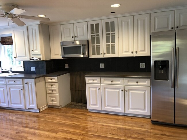
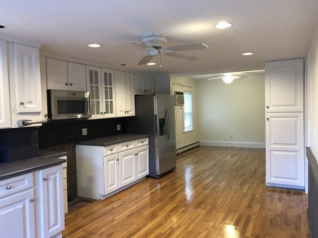
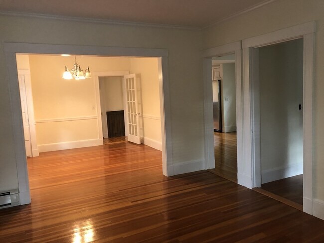
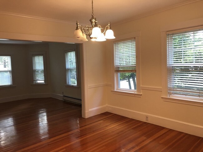
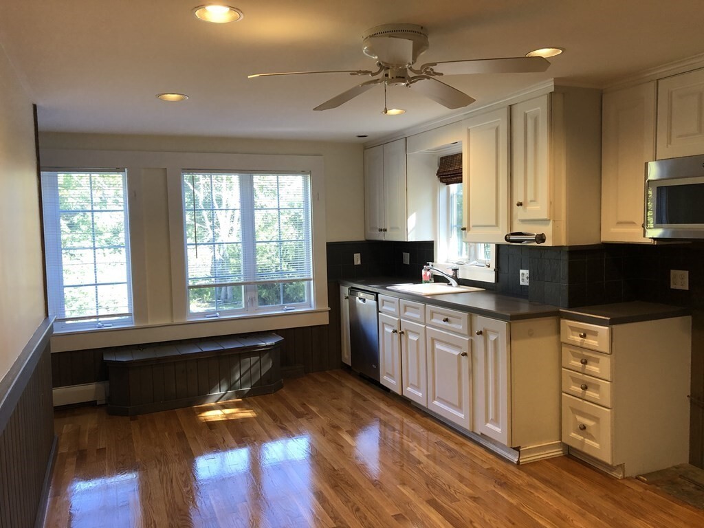
Terrific location! Walk to commuter rail. Whole Foods,restaurants shopping and more! The Wellesley Brook path is steps away. This is the second and third floor of a 3 family home. 3+ Bedrooms 2 full baths! New carpeting in hallways. Recently remodeled kitchen overlooking the family room,stainless steel refrigerator,microwave,stove,plenty of cabinets. Open floor plan; front to back living & dining room. Bonus room,front facing with hardwood floors (extra den/library). Two car assigned paved driveway parking. Washer/dryer in unit. Tenant is responsible for heat,electricity,utilities and Internet. Water,landscaping and snow removal included don’t miss! MLS# 73382513
24 State St is an apartment community located in Norfolk County and the 02482 ZIP Code.
* Price shown is total price based on community-supplied monthly required fees. Excludes user-selected optional fees and variable or usage-based fees and required charges due at or prior to move-in or at move-out. Price, availability, fees, and any applicable rent special are subject to change without notice.
* Square footage definitions vary. Displayed square footage is approximate.
Home Details
Bedrooms and Bathrooms
2 Full Bathrooms
3 Bedrooms
Home Design
Apartment
Entry on the 2nd floor
Interior Spaces
Decorative Lighting
Kitchen
Range
Laundry
Dryer
Laundry in unit
Washer
Listing and Financial Details
Security Deposit $4,300
Assessor Parcel Number 260526
Rent includes water, snow removal, gardener, occupancy only, laundry facilities, parking
Location
Property is near public transit
Property is near schools
Lot Details
229.57 Acre Lot
Landscaped Professionally
Parking
2 Car Parking Spaces
Schools
Wellesley Elementary And Middle School
Wellesley High School
Utilities
Cooling Available
Baseboard Heating
Heating System Uses Natural Gas
Internet Available
Community Details
Amenities
Shops
Common Area
Overview
No Home Owners Association
Pet Policy
Pets Allowed
Recreation
Tennis Courts
Jogging Path
Park
Bike Trail
Fees and Policies
The fees below are based on community-supplied data and may exclude additional fees and utilities.
- One-Time Basics
- Due at Move-In
- Security Deposit - RefundableCharged per unit.$4,300
- Due at Move-In
- Dogs
- Allowed
- Cats
- Allowed
Property Fee Disclaimer: Based on community-supplied data and independent market research. Subject to change without notice. May exclude fees for mandatory or optional services and usage-based utilities.
Contact
- Listed by Jodie Zinna | Coldwell Banker Realty - Wellesley
- Phone Number
-
Source
 MLS Property Information Network
The property listing data and information set forth herein were provided to MLS Property Information Network, Inc. from third party sources, including sellers, lessors and public records, and were compiled by MLS Property Information Network, Inc. The property listing data and information are for the personal, non-commercial use of consumers having a good faith interest in purchasing or leasing listed properties of the type displayed to them and may not be used for any purpose other than to identify prospective properties which such consumers may have a good faith interest in purchasing or leasing. MLS Property Information Network, Inc. and its subscribers disclaim any and all representations and warranties as to the accuracy of the property listing data and information set forth herein. All properties are subject to prior sale, change or withdrawal. Copyright © 2025 MLS Property Information Network, Inc. All rights reserved.
Location
Get Directions
Amenities
- Range
- Refrigerator
Just west of Boston and East of Worcester sits Metro West, a region that houses a group of towns and cities with significant historical backgrounds. A total of 19 municipalities make up the core of this community, but other municipalities are considered to be a part of the Interstate 495/Metro West Corridor.
Learn more about living in Metro West
Education
| Colleges & Universities | Distance | ||
|---|---|---|---|
| Colleges & Universities | Distance | ||
| Drive: | 4 min | 1.4 mi | |
| Drive: | 5 min | 1.7 mi | |
| Drive: | 13 min | 5.9 mi | |
| Drive: | 15 min | 8.0 mi |
24 State St Unit 2 is within 4 minutes or 1.4 miles from Babson College. It is also near Wellesley College and Brandeis University.
Transportation options available in Wellesley include Woodland Station, located 3.4 miles from 24 State St Unit 2. 24 State St Unit 2 is near General Edward Lawrence Logan International, located 17.4 miles or 28 minutes away, and Worcester Regional, located 32.5 miles or 55 minutes away.
| Transit / Subway | Distance | ||
|---|---|---|---|
| Transit / Subway | Distance | ||
|
|
Drive: | 6 min | 3.4 mi |
|
|
Drive: | 8 min | 3.5 mi |
|
|
Drive: | 8 min | 4.1 mi |
|
|
Drive: | 9 min | 4.7 mi |
|
|
Drive: | 9 min | 4.9 mi |
| Commuter Rail | Distance | ||
|---|---|---|---|
| Commuter Rail | Distance | ||
|
|
Walk: | 16 min | 0.9 mi |
|
|
Walk: | 19 min | 1.0 mi |
|
|
Drive: | 5 min | 2.1 mi |
|
|
Drive: | 6 min | 3.1 mi |
|
|
Drive: | 8 min | 3.1 mi |
| Airports | Distance | ||
|---|---|---|---|
| Airports | Distance | ||
|
General Edward Lawrence Logan International
|
Drive: | 28 min | 17.4 mi |
|
Worcester Regional
|
Drive: | 55 min | 32.5 mi |
Time and distance from 24 State St Unit 2.
| Shopping Centers | Distance | ||
|---|---|---|---|
| Shopping Centers | Distance | ||
| Walk: | 2 min | 0.1 mi | |
| Walk: | 9 min | 0.5 mi | |
| Walk: | 13 min | 0.7 mi |
24 State St Unit 2 has 3 shopping centers within 0.7 mile, which is about a 13-minute walk. The miles and minutes will be for the farthest away property.
| Parks and Recreation | Distance | ||
|---|---|---|---|
| Parks and Recreation | Distance | ||
|
Whitin Observatory
|
Drive: | 3 min | 1.2 mi |
|
Wellesley College Botanic Gardens
|
Drive: | 2 min | 1.4 mi |
|
Weezie's Garden for Children
|
Drive: | 8 min | 2.9 mi |
|
Elm Bank Reservation
|
Drive: | 8 min | 2.9 mi |
|
Horticultural Society at Elm Bank
|
Drive: | 9 min | 3.1 mi |
24 State St Unit 2 has 5 parks within 3.1 miles, including Whitin Observatory, Wellesley College Botanic Gardens, and Horticultural Society at Elm Bank.
| Hospitals | Distance | ||
|---|---|---|---|
| Hospitals | Distance | ||
| Drive: | 5 min | 3.1 mi | |
| Drive: | 6 min | 3.3 mi | |
| Drive: | 13 min | 6.3 mi |
24 State St Unit 2 has 3 hospitals within 6.3 miles, the nearest is Newton - Wellesley Hospital which is 3.1 miles away and a 5 minute drive.
| Military Bases | Distance | ||
|---|---|---|---|
| Military Bases | Distance | ||
| Drive: | 8 min | 4.3 mi | |
| Drive: | 24 min | 13.3 mi |
24 State St Unit 2 is 4.3 miles from US Military Reservation, and is convenient to other military bases, including Hanscom Air Force Base.
You May Also Like
-
Station 316 Apartments
316 New Boston St
Woburn, MA 01801
$4,055 - $4,845 Total Monthly Price
3 Br 16.8 mi
-
The Residences at Stevens Pond
1 Founders Way
Saugus, MA 01906
$3,881 - $5,884 Total Monthly Price
3 Br 17.4 mi
-
The Point at Wrentham
50 Ledgeview Way
Wrentham, MA 02093
$3,761 - $5,000 Plus Fees
3 Br 18.1 mi
Similar Rentals Nearby
-
-
-
1 / 14
 3 Beds$2,900+Total Monthly PriceTotal Monthly Price NewPrices include all required monthly fees.1 Month Free
Refrigerator Range Freezer Hardwood Floors Elevator
-
-
3 Beds$6,950+Total Monthly PriceTotal Monthly Price NewPrices include required monthly fees of $10 - $15.Base Rent:3 Beds$6,940+Specials
Pets Allowed Fitness Center In Unit Washer & Dryer Balcony High-Speed Internet Stainless Steel Appliances
-
3 Beds$7,117+Total Monthly PriceTotal Monthly Price NewPrices include required monthly fees of $12.Base Rent:3 Beds$7,105+Specials
Pets Allowed Fitness Center Pool Dishwasher Refrigerator Kitchen
-
-
3 Beds$3,646+Total Monthly PriceTotal Monthly Price NewPrices include base rent and required monthly fees. Variable costs based on usage may apply.
Pets Allowed Fitness Center Pool Dishwasher Kitchen In Unit Washer & Dryer
-
-
3 Beds$3,940+Total Monthly PriceTotal Monthly Price NewPrices include base rent and required monthly fees. Variable costs based on usage may apply.Specials
Pets Allowed Maintenance on site Elevator


What Are Walk Score®, Transit Score®, and Bike Score® Ratings?
Walk Score® measures the walkability of any address. Transit Score® measures access to public transit. Bike Score® measures the bikeability of any address.
What is a Sound Score Rating?
A Sound Score Rating aggregates noise caused by vehicle traffic, airplane traffic and local sources
24 State St
Wellesley, MA 02482