
$2,100 - $2,400
3 Beds, 1 Bath, 1,600 sq ft
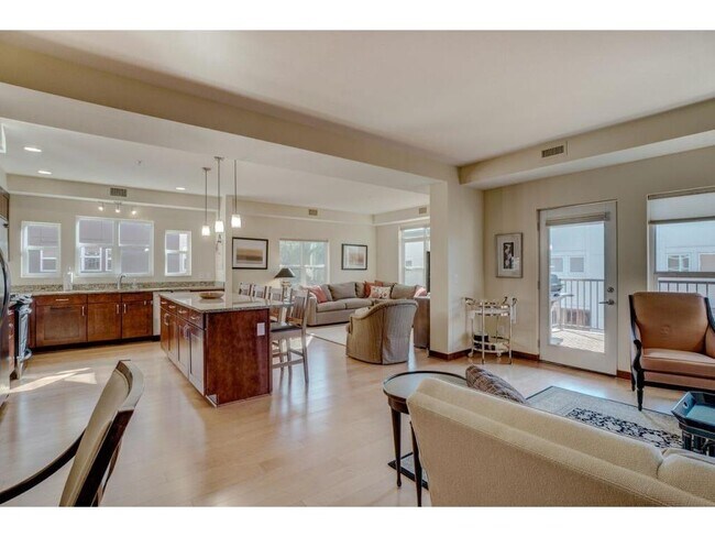
Apartment for Rent

| Beds | Baths | Average SF |
|---|---|---|
| 3 Bedrooms 3 Bedrooms 3 Br | 2 Baths 2 Baths 2 Ba | 2,512 SF |
The fees below are based on community-supplied data and may exclude additional fees and utilities.
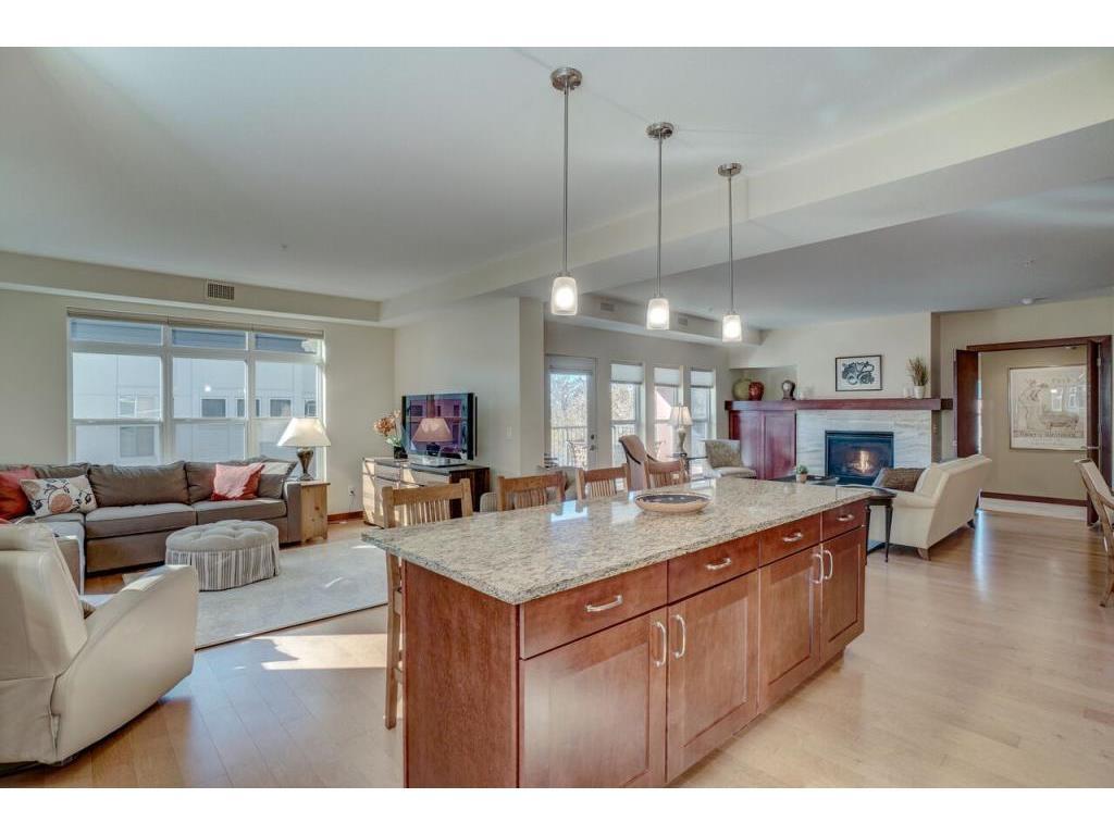
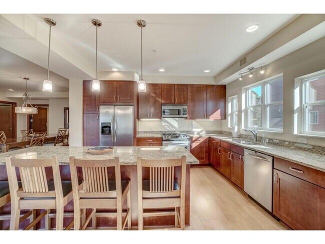
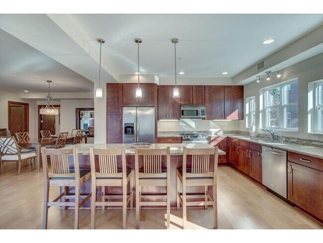
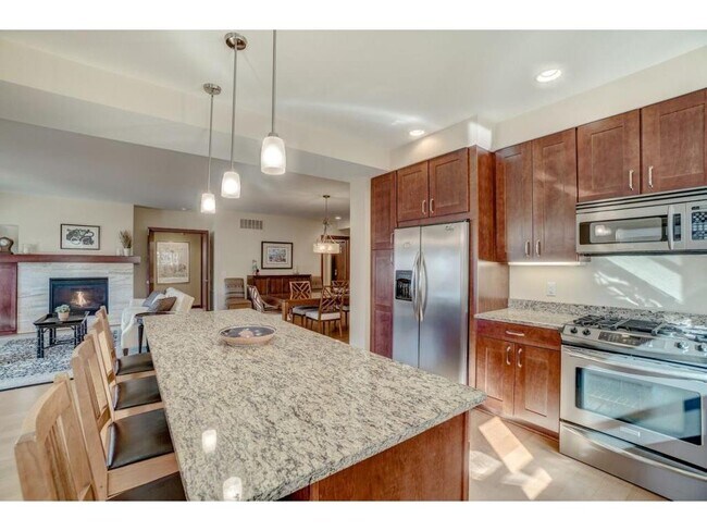
Spacious 3+Den in the Merriam Park West neighborhood of St Paul, just off of Mississippi River Blvd. This Shadow Falls condo occupies the entire 2nd floor of the building with over 2,500 sq ft. Two-stall garage has ample storage space and metal shelving. Take the elevator up from the garage directly to your unit. Unit features hardwood floors, granite counter tops, and wooden built-ins throughout the unit. Gas hook-up for grill on recessed balcony. Within steps of the river front, Lake Street – Marshall Ave Bridge, and golf course. Only a few blocks from St Thomas, museums, local restaurants and shops on Cleveland and Selby.
215 Otis Avenue is a condo located in Ramsey County and the 55104 ZIP Code. This area is served by the St. Paul Public attendance zone.
Along the shore of the Mississippi River, Merriam Park West offers riverfront parks, a large golf course, and quaint local restaurants just minutes from downtown Saint Paul, Minnesota. Stop on in at Izzy’s Ice Cream Café, or grab a treat at Black Coffee and Waffle Bar. Local businesses thrive alongside riverfront community spaces like Shadow Falls Park, a picturesque nature preserve.
The University of Saint Thomas resides on the south end of town, and the neighborhood offers a blend of private and public schools, churches, and every day conveniences. Situated just five miles southeast of Minneapolis and seven miles northeast of the Minneapolis-Saint Paul International Airport, this neighborhood is in a premier location for commuting, shopping, dining, and entertainment.
Learn more about living in Merriam Park West| Beds | Average Size | Lowest | Typical | Premium |
|---|---|---|---|---|
| Studio Studio Studio | 450 Sq Ft | $640 | $984 | $1,200 |
| 1 Bed 1 Bed 1 Bed | 654-657 Sq Ft | $789 | $1,163 | $1,495 |
| 2 Beds 2 Beds 2 Beds | 901-905 Sq Ft | $1,095 | $1,580 | $2,425 |
| 3 Beds 3 Beds 3 Beds | 1407 Sq Ft | $875 | $2,321 | $3,300 |
| 4 Beds 4 Beds 4 Beds | 1808-1824 Sq Ft | $699 | $2,338 | $6,000 |
| Colleges & Universities | Distance | ||
|---|---|---|---|
| Colleges & Universities | Distance | ||
| Walk: | 10 min | 0.6 mi | |
| Drive: | 4 min | 2.1 mi | |
| Drive: | 4 min | 2.3 mi | |
| Drive: | 7 min | 2.4 mi |


Transportation options available in Saint Paul include Raymond Ave Station, located 1.5 miles from 215 Otis Avenue Unit 2. 215 Otis Avenue Unit 2 is near Minneapolis-St Paul International/Wold-Chamberlain, located 7.2 miles or 16 minutes away.
| Transit / Subway | Distance | ||
|---|---|---|---|
| Transit / Subway | Distance | ||
| Drive: | 5 min | 1.5 mi | |
| Drive: | 3 min | 1.7 mi | |
| Drive: | 5 min | 2.1 mi | |
| Drive: | 5 min | 2.2 mi | |
|
|
Drive: | 8 min | 2.7 mi |
| Commuter Rail | Distance | ||
|---|---|---|---|
| Commuter Rail | Distance | ||
|
|
Drive: | 14 min | 6.2 mi |
|
|
Drive: | 11 min | 6.2 mi |
|
|
Drive: | 22 min | 14.7 mi |
|
|
Drive: | 32 min | 23.5 mi |
|
|
Drive: | 33 min | 25.2 mi |
| Airports | Distance | ||
|---|---|---|---|
| Airports | Distance | ||
|
Minneapolis-St Paul International/Wold-Chamberlain
|
Drive: | 16 min | 7.2 mi |
Time and distance from 215 Otis Avenue Unit 2.
| Shopping Centers | Distance | ||
|---|---|---|---|
| Shopping Centers | Distance | ||
| Drive: | 5 min | 2.3 mi | |
| Drive: | 6 min | 2.4 mi | |
| Drive: | 6 min | 2.9 mi |
| Parks and Recreation | Distance | ||
|---|---|---|---|
| Parks and Recreation | Distance | ||
|
Brackett Park
|
Drive: | 4 min | 1.3 mi |
|
Longfellow Park
|
Drive: | 5 min | 1.7 mi |
|
Macalester College Observatory
|
Drive: | 4 min | 2.4 mi |
|
Hiawatha School Park
|
Drive: | 7 min | 2.4 mi |
|
Tower Hill Park
|
Drive: | 6 min | 2.5 mi |
| Hospitals | Distance | ||
|---|---|---|---|
| Hospitals | Distance | ||
| Drive: | 7 min | 3.5 mi | |
| Drive: | 10 min | 3.5 mi | |
| Drive: | 10 min | 3.6 mi |
| Military Bases | Distance | ||
|---|---|---|---|
| Military Bases | Distance | ||
| Drive: | 15 min | 6.1 mi |


What Are Walk Score®, Transit Score®, and Bike Score® Ratings?
Walk Score® measures the walkability of any address. Transit Score® measures access to public transit. Bike Score® measures the bikeability of any address.
What is a Sound Score Rating?
A Sound Score Rating aggregates noise caused by vehicle traffic, airplane traffic and local sources

215 Otis Avenue
Saint Paul, MN 55104