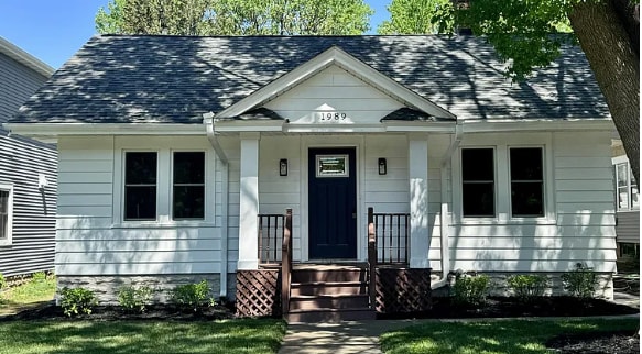
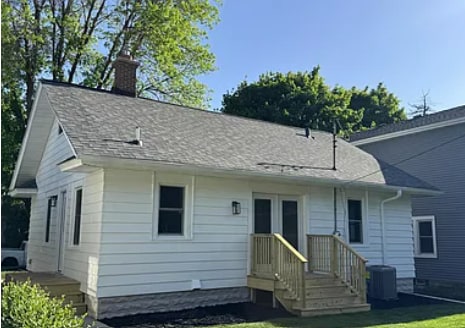
1989 Randolph Ave
Saint Paul, MN 55105
-
Bedrooms
4
-
Bathrooms
2
-
Square Feet
2,134 sq ft
-
Available
Available Aug 1
Highlight
- Hardwood Floors

About This Home
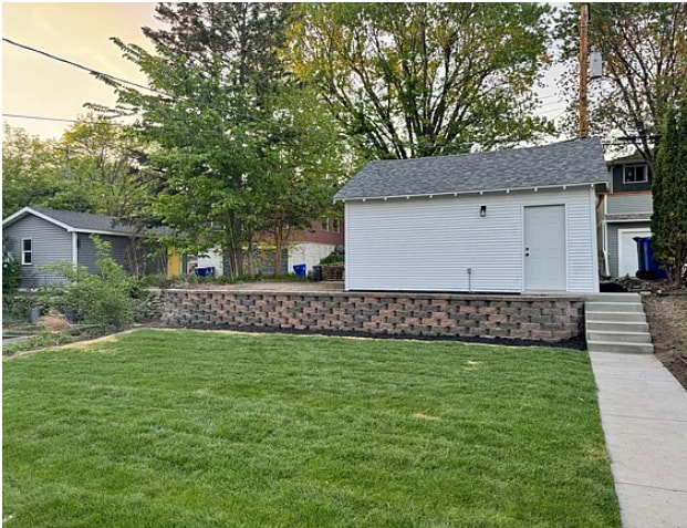
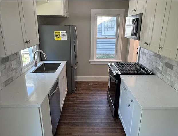
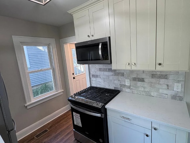
Property Id: 2019782 Rare rental opportunity bordering Mac Groveland and Highland Park. Across street from St. Catherine & 1.2 miles from St. Thomas. This charming home is fully renovated in June 2025. Inside the home there is all new plumbing, electrical, and HVAC including a high efficiency furnace and central air. There is hardwood flooring on the main level. Also, all new stainless steel kitchen appliances along with a new washer and dryer. PLUS new cabinets, dry bar with wine fridge and new tile, carpet, and quartz countertops. Renting as a single home but you can bring roommates with you and each have your own bedroom lease splitting the cost. Subletting available for 1 year lease. Won't be ready to move in until Aug. 1st. Must pass credit and background check and show income or have co-signer. Easy to work with. Great neighbors. Utilities included except cable. Internet, gas, electric, water, trash all covered in your rent.
1989 Randolph Ave is a house located in Ramsey County and the 55105 ZIP Code. This area is served by the St. Paul Public attendance zone.
House Features
Washer/Dryer
Dishwasher
Hardwood Floors
Microwave
- Washer/Dryer
- Dishwasher
- Disposal
- Microwave
- Oven
- Refrigerator
- Hardwood Floors
- Tile Floors
- Bicycle Storage
- Lawn
Fees and Policies
The fees below are based on community-supplied data and may exclude additional fees and utilities.
- Dogs Allowed
-
Fees not specified
-
Weight limit--
-
Pet Limit--
Details
Utilities Included
-
Gas
-
Water
-
Electricity
-
Trash Removal
-
Sewer
Contact
- Phone Number
- Contact
-
Source

- Washer/Dryer
- Dishwasher
- Disposal
- Microwave
- Oven
- Refrigerator
- Hardwood Floors
- Tile Floors
- Lawn
- Bicycle Storage
Macalester-Groveland, sometimes shortened to Mac-Grove, stretches from the eastern banks of the Mississippi River to Summit Hill. Mac-Grove is a largely residential neighborhood, touting an array of apartments and single-family homes available for rent.
The neighborhood contains the picturesque Summit Avenue Historic District, which boasts an impressive collection of Victorian-era homes between dense canopies of lush trees. One block south of Summit Avenue is the vibrant Grand Avenue, which is teeming with specialty shops, independent coffeehouses, and eclectic eateries.
Mac-Grove is famously convenient to multiple private colleges, including the University of Saint Thomas, Saint Catherine University, and Macalester College, making the neighborhood a top choice for many students, faculty, and staff. The community celebrates the start of the summer season every year with the annual Grand Old Day Festival.
Learn more about living in Macalester-Groveland| Colleges & Universities | Distance | ||
|---|---|---|---|
| Colleges & Universities | Distance | ||
| Walk: | 5 min | 0.3 mi | |
| Drive: | 3 min | 1.5 mi | |
| Drive: | 4 min | 1.7 mi | |
| Drive: | 6 min | 2.9 mi |


View GreatSchools Rating Methodology
Data provided by GreatSchools.org © 2025. All rights reserved.
Transportation options available in Saint Paul include Fairview Ave Station, located 2.5 miles from 1989 Randolph Ave. 1989 Randolph Ave is near Minneapolis-St Paul International/Wold-Chamberlain, located 5.5 miles or 12 minutes away.
| Transit / Subway | Distance | ||
|---|---|---|---|
| Transit / Subway | Distance | ||
| Drive: | 5 min | 2.5 mi | |
| Drive: | 6 min | 3.0 mi | |
|
|
Drive: | 7 min | 3.1 mi |
|
|
Drive: | 8 min | 3.4 mi |
|
|
Drive: | 9 min | 3.9 mi |
| Commuter Rail | Distance | ||
|---|---|---|---|
| Commuter Rail | Distance | ||
|
|
Drive: | 13 min | 5.7 mi |
|
|
Drive: | 17 min | 7.7 mi |
|
|
Drive: | 25 min | 16.3 mi |
|
|
Drive: | 35 min | 25.1 mi |
|
|
Drive: | 36 min | 26.7 mi |
| Airports | Distance | ||
|---|---|---|---|
| Airports | Distance | ||
|
Minneapolis-St Paul International/Wold-Chamberlain
|
Drive: | 12 min | 5.5 mi |
Time and distance from 1989 Randolph Ave.
| Shopping Centers | Distance | ||
|---|---|---|---|
| Shopping Centers | Distance | ||
| Walk: | 14 min | 0.7 mi | |
| Walk: | 16 min | 0.8 mi | |
| Drive: | 3 min | 1.2 mi |
| Parks and Recreation | Distance | ||
|---|---|---|---|
| Parks and Recreation | Distance | ||
|
Macalester College Observatory
|
Drive: | 4 min | 1.7 mi |
|
Hidden Falls Park
|
Drive: | 6 min | 2.0 mi |
|
Song of Hiawatha Garden
|
Drive: | 6 min | 2.3 mi |
|
Minnehaha Falls Pergola Garden
|
Drive: | 7 min | 2.4 mi |
|
Hiawatha School Park
|
Drive: | 7 min | 2.6 mi |
| Hospitals | Distance | ||
|---|---|---|---|
| Hospitals | Distance | ||
| Drive: | 9 min | 4.2 mi | |
| Drive: | 10 min | 4.9 mi | |
| Drive: | 10 min | 5.1 mi |
| Military Bases | Distance | ||
|---|---|---|---|
| Military Bases | Distance | ||
| Drive: | 11 min | 4.3 mi |
1989 Randolph Ave Photos
Nearby Apartments
Within 50 Miles of 1989 Randolph Ave Saint Paul, MN 55105
-
3032 3rd Ave S
Minneapolis, MN 55408
4 Br $2,350 4.6 mi
-
400 Cimarron Rd
Apple Valley, MN 55124
4 Br $3,199 10.9 mi
-
707 Oakland Cir
Burnsville, MN 55337
4 Br $2,590 11.7 mi
-
9720 28th Ave N
Minneapolis, MN 55441
5 Br $3,299 12.2 mi
-
Bentley Village
9392-9485 4th St N
Lake Elmo, MN 55042
4 Br $3,570-$3,625 13.3 mi
-
Grand Reserve
10285 Grand Forest Ln
Woodbury, MN 55129
4 Br $3,247-$11,982 14.0 mi
What Are Walk Score®, Transit Score®, and Bike Score® Ratings?
Walk Score® measures the walkability of any address. Transit Score® measures access to public transit. Bike Score® measures the bikeability of any address.
What is a Sound Score Rating?
A Sound Score Rating aggregates noise caused by vehicle traffic, airplane traffic and local sources

1989 Randolph Ave
Saint Paul, MN 55105