
$3,300
/ Month
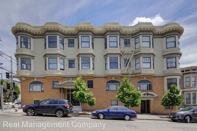
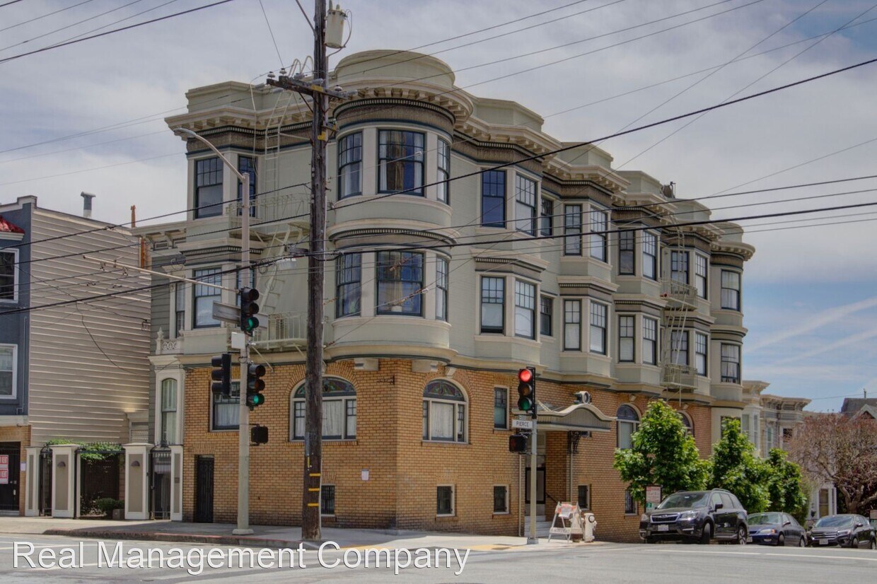
1960 Pierce St
San Francisco, CA 94115
Favorites
1960 Pierce St

Favorites
Check Back Soon for Upcoming Availability
| Beds | Baths | Average SF |
|---|---|---|
| 1 Bedroom 1 Bedroom 1 Br | 1 Bath 1 Bath 1 Ba | — |
Fees and Policies
The fees listed below are community-provided and may exclude utilities or add-ons. All payments are made directly to the property and are non-refundable unless otherwise specified.
- Dogs Allowed
-
Fees not specified
-
Weight limit--
-
Pet Limit--
About This Property
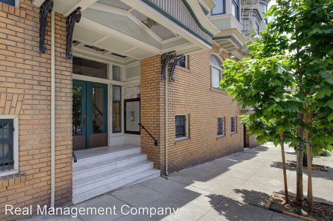
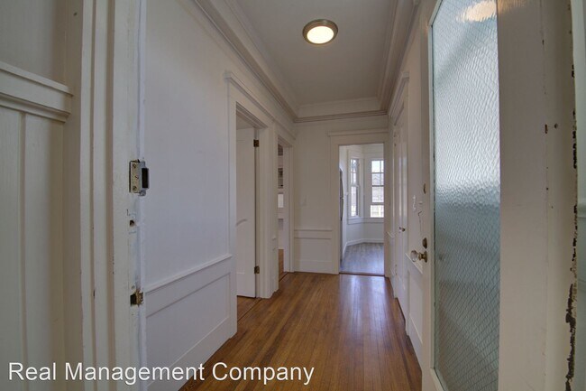
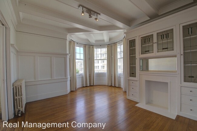
(415) 230-8889 - Fantastic pet friendly top floor 1BR, newly remodeled w/ hardwood floors, laundry - This top floor one bedroom one bathroom apartment is located at 1960 Pierce St at California St in Lower Pacific Heights. It is a terrific blend of old & new and has many modern updates but retains the elegance, scale & beauty of the original building. Several MUNI lines are nearby and shuttles are two blocks away. Features include: Newly remodeled apartment throughout Beautiful dark hardwood floors Living room has decorative fireplace with built in cabinets with leaded glass Eat in gas kitchen with new cabinets, counters, and stainless appliances New bathroom with tub & shower enclosure Western exposure provides lots of natural light Coin laundry in building 12 month lease, tenant pays all utilities One cat or one dog (non aggressive breed) allowed VIRTUAL TOUR HERE - https://my.matterport.com/show/?m=zikqCeqoPBa To schedule an in-person showing please contact Loraine Lee at 415-375-0329 (RLNE5327909) Pet policies: Small Dogs Allowed, Cats Allowed.
1960 Pierce St is an apartment community located in San Francisco County and the 94115 ZIP Code.
1960 Pierce St,
San Francisco,
CA
94115
Lower Pacific Heights is a vibrant San Francisco neighborhood situated between Pacific Heights, Japantown, the Fillmore District, and Laurel Heights. Formerly known as Upper Fillmore, Lower Pacific Heights offers residents a wide variety of apartments, condos, and houses available for rent, many of which boast scenic views due to the neighborhood’s hilly environment.
Lower Pacific Heights is regarded for its walkable layout, with many rentals situated within easy walking distance of the diverse restaurants, shops, coffeehouses, and bars that line Fillmore Street, the community’s main commercial thoroughfare. The neighborhood’s central locale is a major part of its allure, providing quick access to Union Square, the University of San Francisco, the Financial District, several prominent medical centers, tech employers, landmarks, and more.
Learn more about living in Lower Pacific HeightsBelow are rent ranges for similar nearby apartments
Education
| Colleges & Universities | Distance | ||
|---|---|---|---|
| Colleges & Universities | Distance | ||
| Walk: | 6 min | 0.4 mi | |
| Drive: | 4 min | 1.5 mi | |
| Drive: | 5 min | 1.8 mi | |
| Drive: | 7 min | 2.5 mi |
1960 Pierce St is within 6 minutes or 0.4 mile from UC San Francisco, Mount Zion. It is also near University of San Francisco and Academy of Art University.
Transportation options available in San Francisco include Van Ness And California, located 0.9 mile from 1960 Pierce St. 1960 Pierce St is near San Francisco International, located 15.0 miles or 25 minutes away, and Metro Oakland International, located 21.0 miles or 34 minutes away.
| Transit / Subway | Distance | ||
|---|---|---|---|
| Transit / Subway | Distance | ||
|
|
Walk: | 16 min | 0.9 mi |
|
|
Walk: | 20 min | 1.0 mi |
|
|
Walk: | 21 min | 1.1 mi |
| Drive: | 4 min | 1.4 mi | |
| Drive: | 4 min | 1.5 mi |
| Commuter Rail | Distance | ||
|---|---|---|---|
| Commuter Rail | Distance | ||
| Drive: | 8 min | 4.2 mi | |
| Drive: | 14 min | 7.3 mi | |
| Drive: | 20 min | 10.5 mi | |
|
|
Drive: | 21 min | 12.1 mi |
|
|
Drive: | 23 min | 12.6 mi |
| Airports | Distance | ||
|---|---|---|---|
| Airports | Distance | ||
|
San Francisco International
|
Drive: | 25 min | 15.0 mi |
|
Metro Oakland International
|
Drive: | 34 min | 21.0 mi |
Walkability Near 1960 Pierce St San Francisco, CA 94115
Getting Around
 What do Walkability, Transit, Drivability, and Bikeability mean?
Walkability measures the walking distance to day-to-day needs.
Transit measures access to public transportation.
Drivability measures congestion, parking availability, and access to major roads.
Bikeability measures the suitability for cycling.
How It Works
What do Walkability, Transit, Drivability, and Bikeability mean?
Walkability measures the walking distance to day-to-day needs.
Transit measures access to public transportation.
Drivability measures congestion, parking availability, and access to major roads.
Bikeability measures the suitability for cycling.
How It Works
Exceptionally Walkable
Walkability
100
/ 100
Exceptional Public Transit
Transit
100
/ 100
Moderately Drivable
Drivability
60
/ 100
Moderately Bikeable
Bikeability
70
/ 100
Scores provided by
-
Soundscore™
-
/ 100
Traffic
-Airport
-Businesses
-Scores provided by
HowLoud What is a Sound Score Rating? A Sound Score Rating aggregates noise caused by vehicle traffic, airplane traffic and local sources. How It WorksTime and distance from 1960 Pierce St.
| Shopping Centers | Distance | ||
|---|---|---|---|
| Shopping Centers | Distance | ||
| Walk: | 12 min | 0.6 mi | |
| Drive: | 3 min | 1.2 mi | |
| Drive: | 4 min | 1.2 mi |
1960 Pierce St has 3 shopping centers within 1.2 miles, which is about a 4-minute drive. The miles and minutes will be for the farthest away property.
| Parks and Recreation | Distance | ||
|---|---|---|---|
| Parks and Recreation | Distance | ||
|
Buena Vista Park
|
Drive: | 6 min | 1.7 mi |
|
Exploratorium
|
Drive: | 4 min | 1.7 mi |
|
Conservatory of Flowers
|
Drive: | 5 min | 2.1 mi |
|
San Francisco Maritime National Historical Park
|
Drive: | 6 min | 2.3 mi |
|
Randall Museum
|
Drive: | 7 min | 2.5 mi |
1960 Pierce St has 5 parks within 2.5 miles, including Exploratorium, Buena Vista Park, and Randall Museum.
| Hospitals | Distance | ||
|---|---|---|---|
| Hospitals | Distance | ||
| Walk: | 13 min | 0.7 mi | |
| Drive: | 3 min | 1.2 mi | |
| Drive: | 3 min | 1.3 mi |
1960 Pierce St has 3 hospitals within 1.3 miles, the nearest is Kaiser Foundation Hospital - San Francisco which is 0.7 mile away and a 13 minute walk.
| Military Bases | Distance | ||
|---|---|---|---|
| Military Bases | Distance | ||
| Drive: | 11 min | 3.8 mi | |
| Drive: | 12 min | 4.2 mi | |
| Drive: | 17 min | 7.1 mi |
1960 Pierce St has 3 military bases within 7.1 miles, the nearest is East Fort Miley which is 3.8 miles away and a 11 minute drive.
You May Also Like
Similar Rentals Nearby
-
-
-
-
-
-
-
1 Bed$2,190+2 Beds$3,260+Total Monthly PriceTotal Monthly Price NewPrices include base rent and required monthly fees. Variable costs based on usage may apply.Specials
Pets Allowed Dishwasher Walk-In Closets Balcony Maintenance on site CableReady Elevator
-
-
-
1 Bed$2,448+2 Beds$4,572Total Monthly PriceTotal Monthly Price NewPrices include base rent and required monthly fees of $5. Variable costs based on usage may apply.Base Rent:1 Bed$2,442+2 Beds$4,566+2 Months Free
Pets Allowed Fitness Center In Unit Washer & Dryer Walk-In Closets Stainless Steel Appliances Hardwood Floors EV Charging


What Are Walk Score®, Transit Score®, and Bike Score® Ratings?
Walk Score® measures the walkability of any address. Transit Score® measures access to public transit. Bike Score® measures the bikeability of any address.
What is a Sound Score Rating?
A Sound Score Rating aggregates noise caused by vehicle traffic, airplane traffic and local sources.
1960 Pierce St
San Francisco, CA 94115