$1,250
/ Month
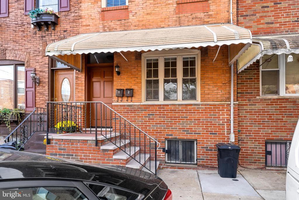
1942 Wolf St
Philadelphia, PA 19145
2 Weeks Ago
|
Edit
Favorites
1942 Wolf St

Favorites
Check Back Soon for Upcoming Availability
| Beds | Baths | Average SF |
|---|---|---|
| 1 Bedroom 1 Bedroom 1 Br | 1 Bath 1 Bath 1 Ba | — |
About This Property
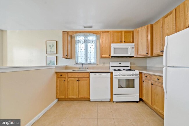
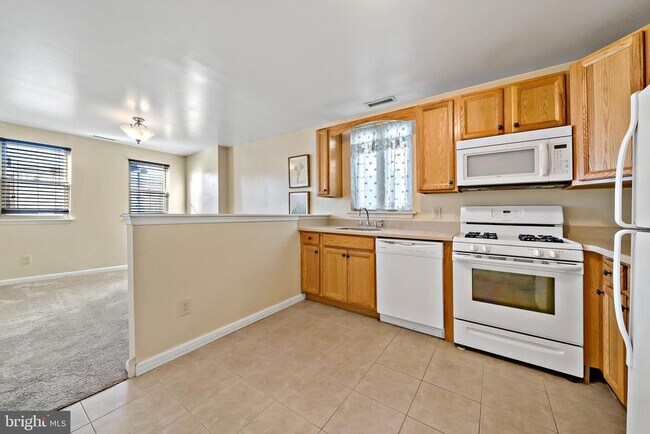
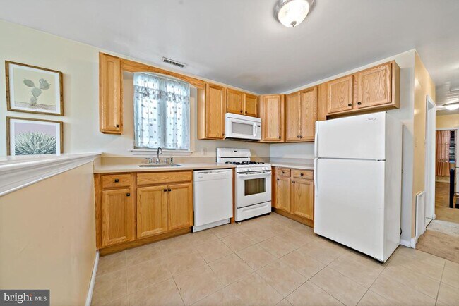
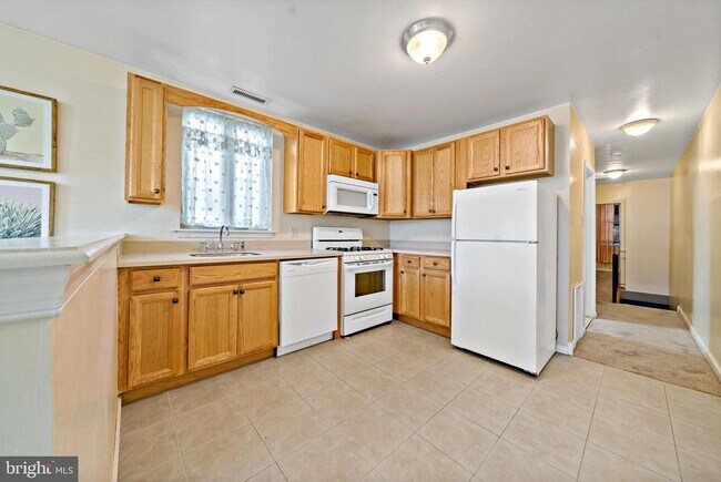
Modern 2nd floor apartment available by November! Living room/ bedroom has carpets. Tilefloor in kitchen with oak cabinets, full size appliances- fridge, gas stove, dishwasher. Tile bath with tub. Bedroom is towards the front of the building. Washer/ dryer in unit with huge laundry room- great for storage. Central air and heat. Close to i95/ i76 and Septa routes! Just off of West Passyunk Ave. Minutes to Center City, Xfinity Live!
1942 Wolf St is a townhome located in Philadelphia County and the 19145 ZIP Code. This area is served by the The School District of Philadelphia attendance zone.
1942 Wolf St,
Philadelphia,
PA
19145
If it's cheesesteaks and sports that piqued your interest in Philadelphia, you're looking for the neighborhood of South Philadelphia West. At its southeastern tip, this area borders the Wells Fargo Center and the Lincoln Financial Field, home of the Flyers and Phillies respectively. Located south of Moore Street, between busy Broad St. and the Schuykill River, the area offers a range of densely packed urban shopping districts and a riverfront oasis, all within minutes of Center City.
Bordered by Interstate 76 and 95, South Philly West encompasses several neighborhoods and entertainment hotspots. There’s a little something for everyone here, from the urban amenities of Melrose and South Philly, to FDR Park and the nearby Philadelphia International Airport.
Learn more about living in South Philadelphia WestBelow are rent ranges for similar nearby apartments
| Beds | Average Size | Lowest | Typical | Premium |
|---|---|---|---|---|
| Studio Studio Studio | 411 Sq Ft | $1,050 | $1,208 | $1,575 |
| 1 Bed 1 Bed 1 Bed | 858 Sq Ft | $1,100 | $1,448 | $2,390 |
| 2 Beds 2 Beds 2 Beds | 984-987 Sq Ft | $1,200 | $1,888 | $3,440 |
| 3 Beds 3 Beds 3 Beds | 1447 Sq Ft | $1,450 | $2,077 | $2,800 |
| 4 Beds 4 Beds 4 Beds | 2000 Sq Ft | $1,875 | $2,458 | $3,200 |
Education
| Colleges & Universities | Distance | ||
|---|---|---|---|
| Colleges & Universities | Distance | ||
| Drive: | 7 min | 2.6 mi | |
| Drive: | 8 min | 2.9 mi | |
| Drive: | 7 min | 3.2 mi | |
| Drive: | 8 min | 3.4 mi |
1942 Wolf St is within 7 minutes or 2.6 miles from The Art Inst. of Philadelphia. It is also near Thomas Jefferson University and University of Pennsylvania.
Schools


Public Elementary School
Grades K-5
293 Students
Attendance Zone
Public Elementary & Middle School
Grades K-8
150 Students
Attendance Zone
Public Elementary & Middle School
Grades PK-8
248 Students
Nearby
Public High School
Grades 9-12
546 Students
Attendance Zone
Private Elementary School
Grades PK-5
11 Students
Nearby
Private Elementary & Middle School
Grades PK-8
565 Students
Nearby
Private High School
Grades 9-12
690 Students
Nearby
School data provided by
 The GreatSchools Rating helps parents compare schools within a state based on a variety of school quality indicators and provides a helpful picture of how effectively each school serves all of its students. Ratings are on a scale of 1 (below average) to 10 (above average) and can include test scores, college readiness, academic progress, advanced courses, equity, discipline and attendance data. We also advise parents to visit schools, consider other information on school performance and programs, and consider family needs as part of the school selection process.
View GreatSchools Rating Methodology
Data provided by GreatSchools.org © 2026. All rights reserved.
View GreatSchools Rating Methodology
Data provided by GreatSchools.org © 2026. All rights reserved.
Transportation options available in Philadelphia include Snyder, located 0.6 mile from 1942 Wolf St. 1942 Wolf St is near Philadelphia International, located 6.9 miles or 16 minutes away, and Trenton Mercer, located 36.0 miles or 55 minutes away.
| Transit / Subway | Distance | ||
|---|---|---|---|
| Transit / Subway | Distance | ||
|
|
Walk: | 11 min | 0.6 mi |
|
|
Walk: | 16 min | 0.9 mi |
|
|
Walk: | 17 min | 0.9 mi |
|
|
Drive: | 4 min | 1.4 mi |
|
|
Drive: | 4 min | 1.7 mi |
| Commuter Rail | Distance | ||
|---|---|---|---|
| Commuter Rail | Distance | ||
|
|
Drive: | 7 min | 2.7 mi |
|
|
Drive: | 8 min | 2.9 mi |
| Drive: | 7 min | 3.1 mi | |
|
|
Drive: | 8 min | 3.2 mi |
|
|
Drive: | 7 min | 3.7 mi |
| Airports | Distance | ||
|---|---|---|---|
| Airports | Distance | ||
|
Philadelphia International
|
Drive: | 16 min | 6.9 mi |
|
Trenton Mercer
|
Drive: | 55 min | 36.0 mi |
Walkability Near 1942 Wolf St Philadelphia, PA 19145
Getting Around
 What do Walkability, Transit, Drivability, and Bikeability mean?
Walkability measures the walking distance to day-to-day needs.
Transit measures access to public transportation.
Drivability measures congestion, parking availability, and access to major roads.
Bikeability measures the suitability for cycling.
How It Works
What do Walkability, Transit, Drivability, and Bikeability mean?
Walkability measures the walking distance to day-to-day needs.
Transit measures access to public transportation.
Drivability measures congestion, parking availability, and access to major roads.
Bikeability measures the suitability for cycling.
How It Works
Exceptionally Walkable
Walkability
100
/ 100
Exceptional Public Transit
Transit
90
/ 100
Somewhat Drivable
Drivability
30
/ 100
Moderately Bikeable
Bikeability
70
/ 100
Scores provided by
-
Soundscore™
-
/ 100
Traffic
-Airport
-Businesses
-Scores provided by
HowLoud What is a Sound Score Rating? A Sound Score Rating aggregates noise caused by vehicle traffic, airplane traffic and local sources. How It WorksTime and distance from 1942 Wolf St.
| Shopping Centers | Distance | ||
|---|---|---|---|
| Shopping Centers | Distance | ||
| Walk: | 8 min | 0.4 mi | |
| Walk: | 10 min | 0.5 mi | |
| Walk: | 10 min | 0.5 mi |
1942 Wolf St has 3 shopping centers within 0.5 mile, which is about a 10-minute walk. The miles and minutes will be for the farthest away property.
| Parks and Recreation | Distance | ||
|---|---|---|---|
| Parks and Recreation | Distance | ||
|
Franklin D. Roosevelt Park
|
Drive: | 7 min | 1.9 mi |
|
Gloria Dei Church National Historic Site
|
Drive: | 7 min | 2.4 mi |
|
Schuylkill River Park
|
Drive: | 7 min | 2.7 mi |
|
Penn Museum
|
Drive: | 7 min | 3.1 mi |
|
Bartram's Garden
|
Drive: | 9 min | 3.5 mi |
1942 Wolf St has 5 parks within 3.5 miles, including Franklin D. Roosevelt Park, Schuylkill River Park, and Gloria Dei Church National Historic Site.
| Hospitals | Distance | ||
|---|---|---|---|
| Hospitals | Distance | ||
| Drive: | 8 min | 2.5 mi | |
| Drive: | 9 min | 2.6 mi | |
| Drive: | 7 min | 2.7 mi |
1942 Wolf St has 3 hospitals within 2.7 miles, the nearest is Pennsylvania Hospital which is 2.5 miles away and a 8 minute drive.
| Military Bases | Distance | ||
|---|---|---|---|
| Military Bases | Distance | ||
| Drive: | 7 min | 2.8 mi |
1942 Wolf St is 2.8 miles and a 7 minute drive from Philadelphia Naval Busi Center.
You May Also Like
Similar Rentals Nearby


What Are Walk Score®, Transit Score®, and Bike Score® Ratings?
Walk Score® measures the walkability of any address. Transit Score® measures access to public transit. Bike Score® measures the bikeability of any address.
What is a Sound Score Rating?
A Sound Score Rating aggregates noise caused by vehicle traffic, airplane traffic and local sources.

1942 Wolf St
Philadelphia, PA 19145