
Hanover Soma West
1140 Harrison St,
San Francisco, CA 94103
$3,475 - $8,729 Total Monthly Price
Studio - 3 Beds
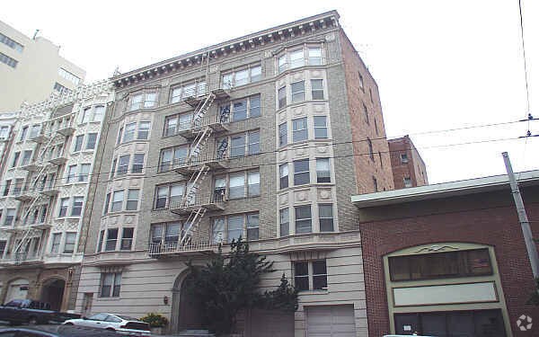

Find your new apartment at 1830 Clay St. This community is located in the Pacific Heights area of San Francisco. The leasing staff is ready for your visit. Compare 1 to 2 bedroom apartments then schedule a visit to see them in person. Stop by the leasing office to talk about renting your new apartment.
1830 Clay St is an apartment community located in San Francisco County and the 94109 ZIP Code. This area is served by the San Francisco Unified School District attendance zone.
Dishwasher
High Speed Internet Access
Smoke Free
Heating
Situated in northern San Francisco, Pacific Heights is a picturesque neighborhood known for its tranquil sophistication, Victorian architecture, and stunning views of the Golden Gate Bridge and the San Francisco Bay. Pacific Heights is a predominantly residential neighborhood, touting a host of apartments in colorful historic buildings as well as numerous extravagant homes along tree-lined streets.
Fillmore Street is the neighborhood’s major thoroughfare, regarded for its high-end boutique shopping and exceptional eateries. Pacific Heights exudes a peaceful atmosphere overall. Residents and visitors take to Alta Plaza Park and Lafayette Park to connect with nature in addition to the famous Presidio, which is adjacent to Pacific Heights. A walkable design along with access to public transit makes getting around from Pacific Heights a breeze.
Learn more about living in Pacific HeightsCompare neighborhood and city base rent averages by bedroom.
| Pacific Heights | San Francisco, CA | |
|---|---|---|
| Studio | $2,640 | $2,591 |
| 1 Bedroom | $3,648 | $3,421 |
| 2 Bedrooms | $4,773 | $4,665 |
| 3 Bedrooms | $7,257 | $5,878 |
| Colleges & Universities | Distance | ||
|---|---|---|---|
| Colleges & Universities | Distance | ||
| Drive: | 4 min | 1.3 mi | |
| Drive: | 4 min | 1.4 mi | |
| Drive: | 6 min | 2.0 mi | |
| Drive: | 7 min | 2.4 mi |


Transportation options available in San Francisco include Van Ness And California, located 0.2 mile from 1830 Clay St. 1830 Clay St is near San Francisco International, located 14.7 miles or 25 minutes away, and Metro Oakland International, located 20.5 miles or 33 minutes away.
| Transit / Subway | Distance | ||
|---|---|---|---|
| Transit / Subway | Distance | ||
|
|
Walk: | 4 min | 0.2 mi |
|
|
Walk: | 7 min | 0.4 mi |
| Walk: | 7 min | 0.4 mi | |
|
|
Walk: | 8 min | 0.4 mi |
| Walk: | 10 min | 0.5 mi |
| Commuter Rail | Distance | ||
|---|---|---|---|
| Commuter Rail | Distance | ||
| Drive: | 8 min | 2.6 mi | |
| Drive: | 14 min | 6.9 mi | |
| Drive: | 19 min | 10.0 mi | |
|
|
Drive: | 20 min | 11.6 mi |
|
|
Drive: | 23 min | 12.1 mi |
| Airports | Distance | ||
|---|---|---|---|
| Airports | Distance | ||
|
San Francisco International
|
Drive: | 25 min | 14.7 mi |
|
Metro Oakland International
|
Drive: | 33 min | 20.5 mi |
Scores provided by
Traffic
-Airport
-Businesses
-Scores provided by
HowLoud What is a Sound Score Rating? A Sound Score Rating aggregates noise caused by vehicle traffic, airplane traffic and local sources. How It WorksTime and distance from 1830 Clay St.
| Shopping Centers | Distance | ||
|---|---|---|---|
| Shopping Centers | Distance | ||
| Walk: | 6 min | 0.3 mi |
| Parks and Recreation | Distance | ||
|---|---|---|---|
| Parks and Recreation | Distance | ||
|
San Francisco Maritime National Historical Park
|
Drive: | 5 min | 1.6 mi |
|
Children's Creativity Museum
|
Drive: | 6 min | 1.9 mi |
|
Aquarium of The Bay
|
Drive: | 6 min | 2.2 mi |
|
Exploratorium
|
Drive: | 7 min | 2.7 mi |
|
Buena Vista Park
|
Drive: | 8 min | 2.7 mi |
| Hospitals | Distance | ||
|---|---|---|---|
| Hospitals | Distance | ||
| Walk: | 9 min | 0.5 mi | |
| Walk: | 10 min | 0.6 mi | |
| Drive: | 4 min | 1.4 mi |
| Military Bases | Distance | ||
|---|---|---|---|
| Military Bases | Distance | ||
| Drive: | 14 min | 4.8 mi | |
| Drive: | 15 min | 5.2 mi | |
| Drive: | 16 min | 6.6 mi |
Pets Allowed Fitness Center In Unit Washer & Dryer Walk-In Closets Stainless Steel Appliances Hardwood Floors EV Charging
What Are Walk Score®, Transit Score®, and Bike Score® Ratings?
Walk Score® measures the walkability of any address. Transit Score® measures access to public transit. Bike Score® measures the bikeability of any address.
What is a Sound Score Rating?
A Sound Score Rating aggregates noise caused by vehicle traffic, airplane traffic and local sources.
1830 Clay St
San Francisco, CA 94109


