$2,200
Total Monthly Price4 Beds, 1 Bath, 1,500 sq ft


Bedrooms
4
Bathrooms
2.5
Square Feet
2,200 sq ft
Available
Available Now

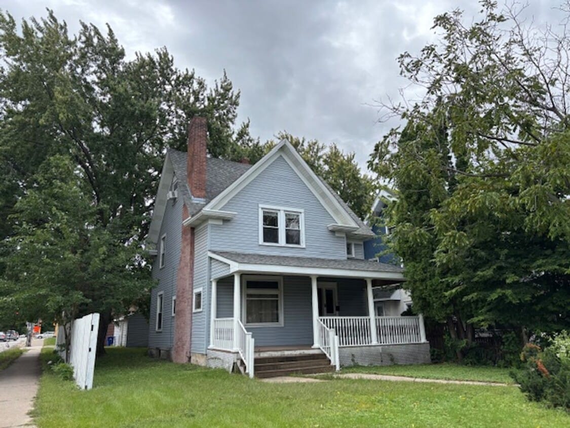
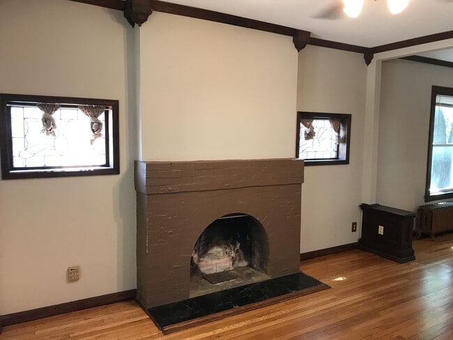
Welcome home to this spacious four-bedroom, two-and-a-half bath home in a great St. Paul neighborhood! Close to the University of St Thomas, Macalester, Concordia and Hamline right up the road, plus tons of shops and dining! This home sits on a large corner lot with a detached two-car detached garage. Hardwood floors throughout and beautiful woodwork through living room, dining room and kitchen. There are three bedrooms upstairs with the fourth in the attic level. The fourth bedroom has a bathroom with shower. Downstairs you have a washer and dryer, another bathroom, and plenty of storage. Tenants are responsible for all utilities, including trash ($45 monthly), a $12 monthly admin fee, as well as lawn care and snow removal. Very sorry, this home is not pet friendly. This is a professionally managed home from the folks at Housing Hub. Online access makes applying, paying rent and scheduling maintenance a breeze. Housing Hub wants to provide you with a great living experience! Application Criteria: 1. Preferred credit score of 650+ 2. Good rental history: No UDs or Evictions 3. Clean background: No Felonies 4. Gross monthly income must be 2.5x the monthly rent 5. 12-month minimum lease term 6. $45 application fee per adult (18+) All information deemed reliable but not guaranteed.
1822 Iglehart Ave is a house located in Ramsey County and the 55104 ZIP Code. This area is served by the St. Paul Public attendance zone.
Along the shore of the Mississippi River, Merriam Park West offers riverfront parks, a large golf course, and quaint local restaurants just minutes from downtown Saint Paul, Minnesota. Stop on in at Izzy’s Ice Cream Café, or grab a treat at Black Coffee and Waffle Bar. Local businesses thrive alongside riverfront community spaces like Shadow Falls Park, a picturesque nature preserve.
The University of Saint Thomas resides on the south end of town, and the neighborhood offers a blend of private and public schools, churches, and every day conveniences. Situated just five miles southeast of Minneapolis and seven miles northeast of the Minneapolis-Saint Paul International Airport, this neighborhood is in a premier location for commuting, shopping, dining, and entertainment.
Learn more about living in Merriam Park West| Colleges & Universities | Distance | ||
|---|---|---|---|
| Colleges & Universities | Distance | ||
| Walk: | 20 min | 1.1 mi | |
| Drive: | 2 min | 1.2 mi | |
| Drive: | 2 min | 1.3 mi | |
| Drive: | 5 min | 2.0 mi |
 The GreatSchools Rating helps parents compare schools within a state based on a variety of school quality indicators and provides a helpful picture of how effectively each school serves all of its students. Ratings are on a scale of 1 (below average) to 10 (above average) and can include test scores, college readiness, academic progress, advanced courses, equity, discipline and attendance data. We also advise parents to visit schools, consider other information on school performance and programs, and consider family needs as part of the school selection process.
Transportation options available in Saint Paul include Fairview Ave Station, located 0.6 mile from 1822 Iglehart Ave. 1822 Iglehart Ave is near Minneapolis-St Paul International/Wold-Chamberlain, located 7.1 miles or 14 minutes away.
| Transit / Subway | Distance | ||
|---|---|---|---|
| Transit / Subway | Distance | ||
| Walk: | 10 min | 0.6 mi | |
| Walk: | 17 min | 0.9 mi | |
| Drive: | 2 min | 1.4 mi | |
| Drive: | 4 min | 1.7 mi | |
| Drive: | 3 min | 1.9 mi |
| Commuter Rail | Distance | ||
|---|---|---|---|
| Commuter Rail | Distance | ||
|
|
Drive: | 9 min | 5.2 mi |
|
|
Drive: | 14 min | 6.6 mi |
|
|
Drive: | 22 min | 15.2 mi |
|
|
Drive: | 32 min | 24.0 mi |
|
|
Drive: | 33 min | 25.6 mi |
| Airports | Distance | ||
|---|---|---|---|
| Airports | Distance | ||
|
Minneapolis-St Paul International/Wold-Chamberlain
|
Drive: | 14 min | 7.1 mi |
Time and distance from 1822 Iglehart Ave.
| Shopping Centers | Distance | ||
|---|---|---|---|
| Shopping Centers | Distance | ||
| Drive: | 2 min | 1.3 mi | |
| Drive: | 3 min | 1.3 mi | |
| Drive: | 3 min | 1.5 mi |
| Parks and Recreation | Distance | ||
|---|---|---|---|
| Parks and Recreation | Distance | ||
|
Macalester College Observatory
|
Drive: | 2 min | 1.3 mi |
|
Newell Park
|
Drive: | 3 min | 1.3 mi |
|
Brackett Park
|
Drive: | 6 min | 2.3 mi |
|
Tower Hill Park
|
Drive: | 6 min | 2.5 mi |
|
Longfellow Park
|
Drive: | 6 min | 2.7 mi |
| Hospitals | Distance | ||
|---|---|---|---|
| Hospitals | Distance | ||
| Drive: | 7 min | 4.0 mi | |
| Drive: | 7 min | 4.1 mi | |
| Drive: | 7 min | 4.1 mi |
| Military Bases | Distance | ||
|---|---|---|---|
| Military Bases | Distance | ||
| Drive: | 13 min | 5.8 mi |
$2,200
Total Monthly Price4 Beds, 1 Bath, 1,500 sq ft
$3,200
Total Monthly Price4 Beds, 1.5 Baths, 1,868 sq ft
$2,880
Total Monthly Price4 Beds, 2 Baths, 2,950 sq ft
$2,600
Total Monthly Price4 Beds, 2 Baths, 2,400 sq ft
$2,675
Total Monthly Price Total Monthly Price New4 Beds, 1.5 Baths, 2,272 sq ft
$3,575 - $3,670
Total Monthly Price4 Beds
What Are Walk Score®, Transit Score®, and Bike Score® Ratings?
Walk Score® measures the walkability of any address. Transit Score® measures access to public transit. Bike Score® measures the bikeability of any address.
What is a Sound Score Rating?
A Sound Score Rating aggregates noise caused by vehicle traffic, airplane traffic and local sources