


$1,275
/ Month
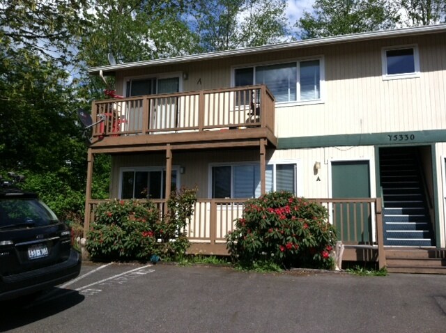
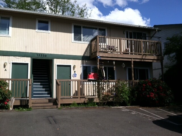
15330 1st Ave NE Unit C
Duvall, WA 98019
2 Weeks Ago
Favorites
15330 1st Ave NE Unit C

Favorites
Check Back Soon for Upcoming Availability
| Beds | Baths | Average SF |
|---|---|---|
| 2 Bedrooms 2 Bedrooms 2 Br | 1 Bath 1 Bath 1 Ba | 820 SF |
Fees and Policies
The fees below are based on community-supplied data and may exclude additional fees and utilities.
- Parking
-
Surface Lot--
Details
Property Information
-
4 units
About This Property
Walking distance to library, grocery store, restaurants and park.
15330 1st Ave NE is an apartment community located in King County and the 98019 ZIP Code.
Apartment Features
Washer/Dryer
Refrigerator
Tub/Shower
Smoke Free
- Washer/Dryer
- Smoke Free
- Tub/Shower
- Refrigerator
- Carpet
- Balcony
- Deck
Location
Get Directions
Amenities
- Washer/Dryer
- Smoke Free
- Tub/Shower
- Refrigerator
- Carpet
- Balcony
- Deck
Education
| Colleges & Universities | Distance | ||
|---|---|---|---|
| Colleges & Universities | Distance | ||
| Drive: | 20 min | 10.6 mi | |
| Drive: | 23 min | 12.7 mi | |
| Drive: | 28 min | 13.4 mi | |
| Drive: | 35 min | 17.6 mi |
15330 1st Ave NE Unit C is within 20 minutes or 10.6 miles from Lake Wash. Tech., Redmond. It is also near Univ. of Wash., Bothell and Lake Wash. Tech., Kirkland.
Transportation options available in Duvall include Redmond Technology, located 14.6 miles from 15330 1st Ave NE Unit C. 15330 1st Ave NE Unit C is near Seattle Paine Field International, located 25.9 miles or 43 minutes away, and Seattle-Tacoma International, located 33.8 miles or 52 minutes away.
| Transit / Subway | Distance | ||
|---|---|---|---|
| Transit / Subway | Distance | ||
| Drive: | 25 min | 14.6 mi |
| Commuter Rail | Distance | ||
|---|---|---|---|
| Commuter Rail | Distance | ||
|
|
Drive: | 47 min | 24.3 mi |
|
|
Drive: | 38 min | 25.1 mi |
|
|
Drive: | 40 min | 25.7 mi |
|
|
Drive: | 48 min | 28.8 mi |
|
|
Drive: | 46 min | 30.5 mi |
| Airports | Distance | ||
|---|---|---|---|
| Airports | Distance | ||
|
Seattle Paine Field International
|
Drive: | 43 min | 25.9 mi |
|
Seattle-Tacoma International
|
Drive: | 52 min | 33.8 mi |
Time and distance from 15330 1st Ave NE Unit C.
| Shopping Centers | Distance | ||
|---|---|---|---|
| Shopping Centers | Distance | ||
| Walk: | 2 min | 0.1 mi | |
| Walk: | 3 min | 0.2 mi | |
| Walk: | 10 min | 0.5 mi |
15330 1st Ave NE Unit C has 3 shopping centers within 0.5 mile, which is about a 10-minute walk. The miles and minutes will be for the farthest away property.
| Parks and Recreation | Distance | ||
|---|---|---|---|
| Parks and Recreation | Distance | ||
|
Watershed Preserve
|
Drive: | 11 min | 5.9 mi |
|
Perrigo Community Park
|
Drive: | 15 min | 7.9 mi |
|
Arthur Johnson Park
|
Drive: | 16 min | 8.5 mi |
|
Juel Community Park
|
Drive: | 19 min | 10.0 mi |
|
Farrel McWhirter Park
|
Drive: | 21 min | 10.4 mi |
15330 1st Ave NE Unit C has 5 parks within 10.4 miles, including Watershed Preserve, Perrigo Community Park, and Arthur Johnson Park.
| Hospitals | Distance | ||
|---|---|---|---|
| Hospitals | Distance | ||
| Drive: | 18 min | 10.7 mi | |
| Drive: | 27 min | 15.8 mi |
15330 1st Ave NE Unit C is 10.7 miles from EvergreenHealth Monroe, and is convenient to other hospitals, including EvergreenHealth Medical Center.
| Military Bases | Distance | ||
|---|---|---|---|
| Military Bases | Distance | ||
| Drive: | 40 min | 25.9 mi | |
| Drive: | 54 min | 28.3 mi |
15330 1st Ave NE Unit C is 25.9 miles from Everett Naval Station, and is convenient to other military bases, including Fort Lawton Military Reserve.
You May Also Like
Similar Rentals Nearby


What Are Walk Score®, Transit Score®, and Bike Score® Ratings?
Walk Score® measures the walkability of any address. Transit Score® measures access to public transit. Bike Score® measures the bikeability of any address.
What is a Sound Score Rating?
A Sound Score Rating aggregates noise caused by vehicle traffic, airplane traffic and local sources

15330 1st Ave NE
Duvall, WA 98019