$1,299 / Month
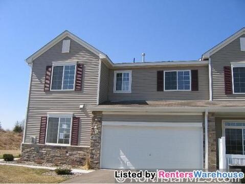
1512 139th St W
Rosemount, MN 55068
2 Weeks Ago
Favorites
1512 139th St W

Favorites
Check Back Soon for Upcoming Availability
| Beds | Baths | Average SF |
|---|---|---|
| 2 Bedrooms 2 Bedrooms 2 Br | 1 Bath 1 Bath 1 Ba | 1,600 SF |
About This Property
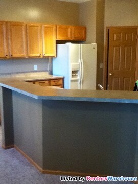
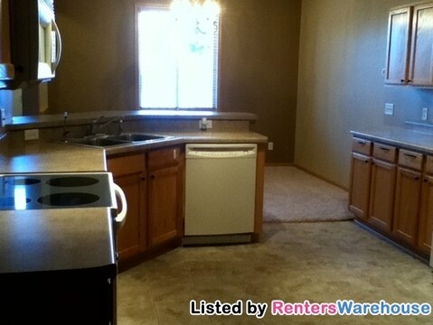
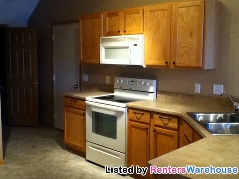
Another great listing presented by Aric Berg and Renters Warehouse. It has been NEWLY painted & includes 2 VERY LARGE BEDROOMS and a HUGE DEN making it great for a family. This is a END UNIT with HIGH CEILINGS and a HUGE KITCHEN with tons of cabinet's. There is also a patio off the kitchen. Main level includes a half bathroom and is great for entertaining. You also have a large 2 CAR GARAGE that has an abundance of storage space. This home is beautiful, clean and available ASAP. No evictions, No pets.. This home will go fast so EMAIL for quickest response and showing setup (new pictures coming soon)
1512 139th St W is a townhome located in Dakota County and the 55068 ZIP Code. This area is served by the Rosemount-Apple Valley-Eagan attendance zone.
Location
Get Directions
Located about 16 miles south of St. Paul, Rosemount borders Spring Lake along the Mississippi River. It is home to the University of Minnesota-UMore Park along with several industries, including Flint Hills Resources oil refinery, the Pine Bend Refinery -- the largest in the state. UMore (University of Minnesota Outreach, Research, and Education) Park is located on 5,000 acres and focuses on renewable energy, education, technology, environmental quality, and other factors.
Rosemount, while home to some serious industry, also has a quirky side. The city is the only one to serve as multiple-time hosts to the USA Broomball National Championships. The annual Leprechaun Days, held every July, began in the 1960s and includes a chili cook-off, a parade, fireworks, carnival rides, a beer garden, and the Midsummer Faire, held in Rosemont Park.
Learn more about living in Rosemount
Education
| Colleges & Universities | Distance | ||
|---|---|---|---|
| Colleges & Universities | Distance | ||
| Drive: | 17 min | 9.9 mi | |
| Drive: | 18 min | 10.8 mi | |
| Drive: | 28 min | 16.2 mi | |
| Drive: | 31 min | 18.3 mi |
1512 139th St W is within 18 minutes or 10.8 miles from Inver Hills Community College. It is also near Argosy University, Twin Cities and St. Catherine University.
Schools


Public Elementary, Middle & High School
Grades PK-12
21 Students
Nearby
Public Elementary School
Grades K-5
728 Students
Attendance Zone
Public Middle School
Grades 6-8
1,205 Students
Attendance Zone
Public High School
Grades 9-12
2,425 Students
Attendance Zone
Private Elementary & Middle School
Grades PK-8
121 Students
Nearby
Private Elementary, Middle & High School
Grades PK-12
233 Students
Nearby
Private Elementary & Middle School
Grades PK-8
251 Students
Nearby
School data provided by
 The GreatSchools Rating helps parents compare schools within a state based on a variety of school quality indicators and provides a helpful picture of how effectively each school serves all of its students. Ratings are on a scale of 1 (below average) to 10 (above average) and can include test scores, college readiness, academic progress, advanced courses, equity, discipline and attendance data. We also advise parents to visit schools, consider other information on school performance and programs, and consider family needs as part of the school selection process.
View GreatSchools Rating Methodology
Data provided by GreatSchools.org © 2025. All rights reserved.
View GreatSchools Rating Methodology
Data provided by GreatSchools.org © 2025. All rights reserved.
Transportation options available in Rosemount include Mall Of America Station, located 13.9 miles from 1512 139th St W. 1512 139th St W is near Minneapolis-St Paul International/Wold-Chamberlain, located 16.0 miles or 25 minutes away.
| Transit / Subway | Distance | ||
|---|---|---|---|
| Transit / Subway | Distance | ||
|
|
Drive: | 22 min | 13.9 mi |
|
|
Drive: | 22 min | 14.2 mi |
|
|
Drive: | 23 min | 14.4 mi |
|
|
Drive: | 23 min | 15.2 mi |
| Commuter Rail | Distance | ||
|---|---|---|---|
| Commuter Rail | Distance | ||
|
|
Drive: | 27 min | 18.2 mi |
|
|
Drive: | 38 min | 21.5 mi |
|
|
Drive: | 46 min | 30.0 mi |
|
|
Drive: | 51 min | 37.3 mi |
|
|
Drive: | 59 min | 44.6 mi |
| Airports | Distance | ||
|---|---|---|---|
| Airports | Distance | ||
|
Minneapolis-St Paul International/Wold-Chamberlain
|
Drive: | 25 min | 16.0 mi |
Time and distance from 1512 139th St W.
| Shopping Centers | Distance | ||
|---|---|---|---|
| Shopping Centers | Distance | ||
| Drive: | 5 min | 2.9 mi | |
| Drive: | 6 min | 3.1 mi | |
| Drive: | 6 min | 3.2 mi |
1512 139th St W has 3 shopping centers within 3.2 miles, which is about a 6-minute drive. The miles and minutes will be for the farthest away property.
| Parks and Recreation | Distance | ||
|---|---|---|---|
| Parks and Recreation | Distance | ||
|
Minnesota Zoo
|
Drive: | 14 min | 6.8 mi |
|
Spring Lake Reserve
|
Drive: | 14 min | 7.6 mi |
|
Minnesota Valley National Wildlife Refuge
|
Drive: | 21 min | 11.3 mi |
|
Dakota City
|
Drive: | 22 min | 12.3 mi |
|
Buck Hill
|
Drive: | 20 min | 12.6 mi |
1512 139th St W has 5 parks within 12.6 miles, including Minnesota Zoo, Spring Lake Reserve, and Dakota City.
| Hospitals | Distance | ||
|---|---|---|---|
| Hospitals | Distance | ||
| Drive: | 18 min | 9.5 mi |
1512 139th St W is 9.5 miles and a 18 minute drive from Fairview Ridges Hospital.
| Military Bases | Distance | ||
|---|---|---|---|
| Military Bases | Distance | ||
| Drive: | 23 min | 14.9 mi |
1512 139th St W is 14.9 miles and a 23 minute drive from Fort Snelling Military Reservation.
You May Also Like
Similar Rentals Nearby


What Are Walk Score®, Transit Score®, and Bike Score® Ratings?
Walk Score® measures the walkability of any address. Transit Score® measures access to public transit. Bike Score® measures the bikeability of any address.
What is a Sound Score Rating?
A Sound Score Rating aggregates noise caused by vehicle traffic, airplane traffic and local sources

1512 139th St W
Rosemount, MN 55068