
Isle House
39 Bruton St,
San Francisco, CA 94130
$3,265 - $7,635
Studio - 3 Beds

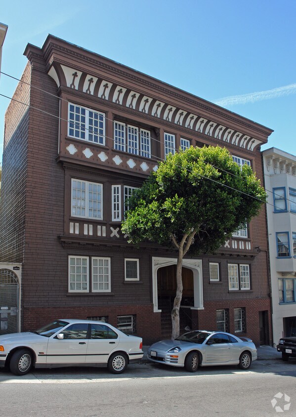
This Nob Hill 16-unit property is located one block away from the world-famous San Francisco Cable Cars where you can commute to Fisherman’s Wharf at Pier 39 or the Financial District and Embarcadero. You can do your grocery shopping at the local Trader Joes and enjoy the vibrant night life of Polk Street; just a short walk away from your new home at 1433 Clay. 1433 Clay Street is comprised of one, two, and three bedroom units. Amenities include gated access, on-site laundry, on-site management, and intercom system use. This rental community is pet-friendly, welcoming both cats and dogs. For details, please email us at [email address removed] or contact our office at (415) 520-7290 and we will get back to you as soon as possible.
1433 Clay is an apartment community located in San Francisco County and the 94109 ZIP Code. This area is served by the San Francisco Unified attendance zone.
Laundry Facilities
Recycling
Gated
24 Hour Access
Washer/Dryer
Dishwasher
Hardwood Floors
Refrigerator
Located directly west of Chinatown, Nob Hill is an affluent neighborhood in the heart of San Francisco, California. Nob Hill is just minutes from Civic Center, North Beach, Fisherman’s Wharf, and other popular neighborhood destinations.
Visit Pier 39 in North Beach to explore this bustling bayside pier with scenic views, sea-lion sightings, dining options, unique shops, and family-friendly entertainment. Relax on the lawn in Huntington Park surrounded by Nob Hill’s high-rise buildings and beautiful architecture. Residents and visitors alike flock to Bob’s Donuts and Pastries, a local favorite around town. Splurge on a night out at House of Prime Rib, a longstanding, fancy English-style restaurant with premier food and fine wines.
Beautiful high-rise apartments, modern condos, and cozy townhomes are spread throughout Nob Hill, creating an urban oasis just minutes from San Francisco’s greatest attractions.
Learn more about living in Nob Hill| Colleges & Universities | Distance | ||
|---|---|---|---|
| Colleges & Universities | Distance | ||
| Walk: | 9 min | 0.5 mi | |
| Drive: | 4 min | 1.5 mi | |
| Drive: | 5 min | 1.7 mi | |
| Drive: | 8 min | 2.6 mi |


Transportation options available in San Francisco include Leavenworth And Washington, located 0.1 mile from 1433 Clay. 1433 Clay is near San Francisco International, located 15.0 miles or 25 minutes away, and Metro Oakland International, located 19.9 miles or 31 minutes away.
| Transit / Subway | Distance | ||
|---|---|---|---|
| Transit / Subway | Distance | ||
|
|
Walk: | 1 min | 0.1 mi |
|
|
Walk: | 2 min | 0.1 mi |
|
|
Walk: | 3 min | 0.2 mi |
|
|
Walk: | 3 min | 0.2 mi |
|
|
Walk: | 3 min | 0.2 mi |
| Commuter Rail | Distance | ||
|---|---|---|---|
| Commuter Rail | Distance | ||
| Drive: | 5 min | 2.0 mi | |
| Drive: | 6 min | 2.0 mi | |
| Drive: | 7 min | 3.5 mi | |
| Drive: | 7 min | 3.5 mi | |
| Drive: | 13 min | 7.1 mi |
| Airports | Distance | ||
|---|---|---|---|
| Airports | Distance | ||
|
San Francisco International
|
Drive: | 25 min | 15.0 mi |
|
Metro Oakland International
|
Drive: | 31 min | 19.9 mi |
Time and distance from 1433 Clay.
| Shopping Centers | Distance | ||
|---|---|---|---|
| Shopping Centers | Distance | ||
| Walk: | 11 min | 0.6 mi | |
| Drive: | 3 min | 1.1 mi | |
| Drive: | 5 min | 1.5 mi |
| Parks and Recreation | Distance | ||
|---|---|---|---|
| Parks and Recreation | Distance | ||
|
San Francisco Maritime National Historical Park
|
Drive: | 3 min | 1.2 mi |
|
Children's Creativity Museum
|
Drive: | 4 min | 1.4 mi |
|
Aquarium of The Bay
|
Drive: | 5 min | 1.6 mi |
|
Exploratorium
|
Drive: | 8 min | 3.1 mi |
|
Buena Vista Park
|
Drive: | 9 min | 3.1 mi |
| Hospitals | Distance | ||
|---|---|---|---|
| Hospitals | Distance | ||
| Walk: | 5 min | 0.3 mi | |
| Walk: | 10 min | 0.6 mi | |
| Walk: | 14 min | 0.7 mi |
| Military Bases | Distance | ||
|---|---|---|---|
| Military Bases | Distance | ||
| Drive: | 15 min | 5.1 mi | |
| Drive: | 14 min | 6.0 mi | |
| Drive: | 28 min | 14.5 mi |
What Are Walk Score®, Transit Score®, and Bike Score® Ratings?
Walk Score® measures the walkability of any address. Transit Score® measures access to public transit. Bike Score® measures the bikeability of any address.
What is a Sound Score Rating?
A Sound Score Rating aggregates noise caused by vehicle traffic, airplane traffic and local sources
1433 Clay St
San Francisco, CA 94109


