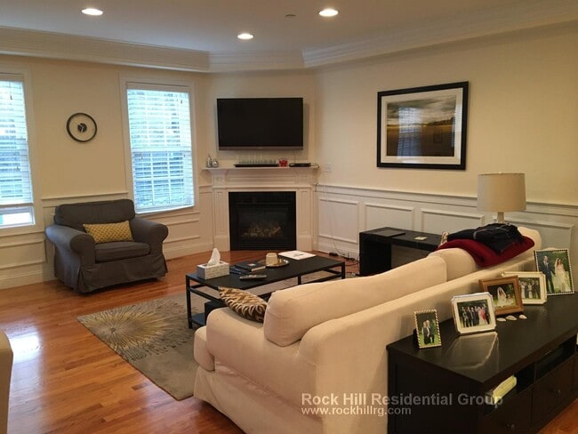
139 Tremont St Unit 139
Boston, MA 02111
-
Bedrooms
3
-
Bathrooms
2.5
-
Square Feet
999 sq ft
-
Available
Available Now

Contact
- Phone Number
- Contact
With all due respect to the rest of the Emerald Necklace, Boston Common is arguably the city’s most beautiful and famous green space, and folks who live in the apartments surrounding it enjoy some of the best views in town—and the greatest front yard anyone could hope for. Aside from the park itself, the architecture is gorgeous, with classic historic mid-rises and sleek modern designs side by side.
Emerson College occupies a considerable amount of real estate on Boylston Street, making this area ideal for students, faculty, and staff. Folks who like to go out on the town don’t have to travel far: the community is jam packed with restaurants, coffee shops, bars, night clubs, and performing arts venues, ensuring that there is truly something for every taste.
Learn more about living in Boston Common| Colleges & Universities | Distance | ||
|---|---|---|---|
| Colleges & Universities | Distance | ||
| Walk: | 6 min | 0.3 mi | |
| Walk: | 11 min | 0.6 mi | |
| Drive: | 4 min | 1.3 mi | |
| Drive: | 5 min | 1.7 mi |
Transportation options available in Boston include Downtown Crossing Station, located 0.2 mile from 139 Tremont St Unit 139. 139 Tremont St Unit 139 is near General Edward Lawrence Logan International, located 4.8 miles or 11 minutes away.
| Transit / Subway | Distance | ||
|---|---|---|---|
| Transit / Subway | Distance | ||
|
|
Walk: | 4 min | 0.2 mi |
|
|
Walk: | 4 min | 0.2 mi |
|
|
Walk: | 5 min | 0.3 mi |
|
|
Walk: | 7 min | 0.4 mi |
|
|
Drive: | 3 min | 1.2 mi |
| Commuter Rail | Distance | ||
|---|---|---|---|
| Commuter Rail | Distance | ||
|
|
Walk: | 12 min | 0.7 mi |
|
|
Drive: | 5 min | 1.2 mi |
|
|
Drive: | 6 min | 1.9 mi |
|
|
Drive: | 6 min | 2.2 mi |
| Drive: | 6 min | 2.6 mi |
| Airports | Distance | ||
|---|---|---|---|
| Airports | Distance | ||
|
General Edward Lawrence Logan International
|
Drive: | 11 min | 4.8 mi |
Scores provided by
Traffic
BusyAirport
ActiveBusinesses
BusyScores provided by
HowLoud What is a Sound Score Rating? A Sound Score Rating aggregates noise caused by vehicle traffic, airplane traffic and local sources. How It WorksTime and distance from 139 Tremont St Unit 139.
| Shopping Centers | Distance | ||
|---|---|---|---|
| Shopping Centers | Distance | ||
| Drive: | 4 min | 1.1 mi | |
| Drive: | 4 min | 1.3 mi | |
| Drive: | 6 min | 1.8 mi |
| Parks and Recreation | Distance | ||
|---|---|---|---|
| Parks and Recreation | Distance | ||
|
Boston Public Garden
|
Walk: | 6 min | 0.3 mi |
|
Boston National Historical Park
|
Walk: | 10 min | 0.5 mi |
|
Boston Harbor Islands National Recreation Area
|
Walk: | 16 min | 0.9 mi |
|
Boston Children's Museum
|
Walk: | 17 min | 0.9 mi |
|
Boston African American National Historic Site
|
Drive: | 3 min | 1.2 mi |
| Hospitals | Distance | ||
|---|---|---|---|
| Hospitals | Distance | ||
| Walk: | 9 min | 0.5 mi | |
| Drive: | 5 min | 1.6 mi | |
| Drive: | 5 min | 1.7 mi |
| Military Bases | Distance | ||
|---|---|---|---|
| Military Bases | Distance | ||
| Drive: | 31 min | 16.7 mi | |
| Drive: | 33 min | 18.9 mi | |
| Drive: | 34 min | 20.2 mi |
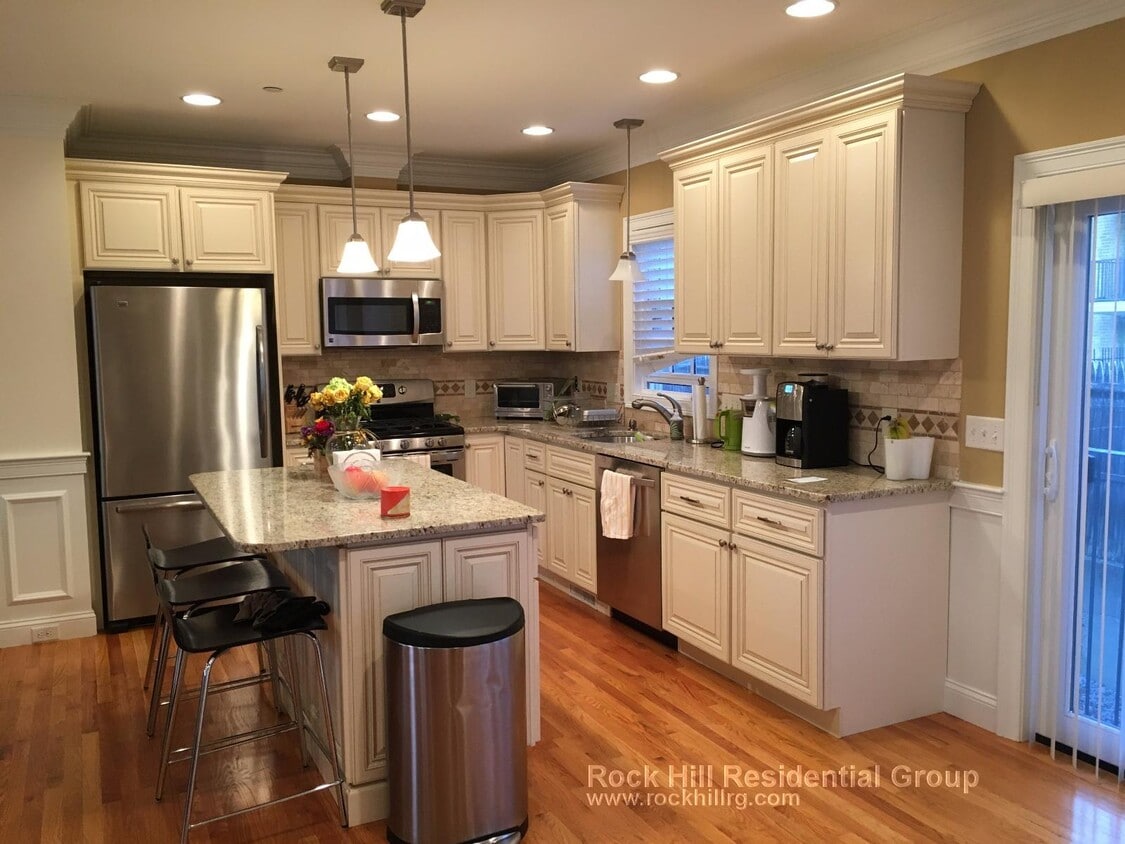
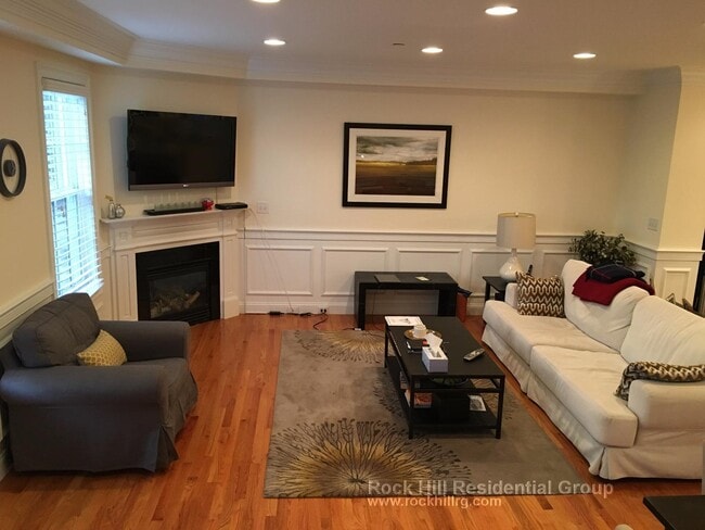
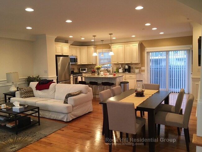
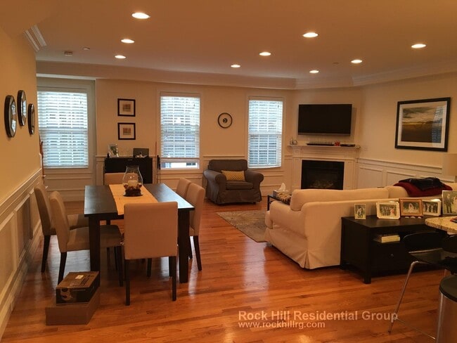
139 Tremont St Unit 139 Photos
What Are Walk Score®, Transit Score®, and Bike Score® Ratings?
Walk Score® measures the walkability of any address. Transit Score® measures access to public transit. Bike Score® measures the bikeability of any address.
What is a Sound Score Rating?
A Sound Score Rating aggregates noise caused by vehicle traffic, airplane traffic and local sources.

139 Tremont St
Boston, MA 02111