$3,500
Total Monthly Price4 Beds, 2 Baths, 1,531 sq ft


Bedrooms
5
Bathrooms
2
Square Feet
1,900 sq ft
Available
Available Now

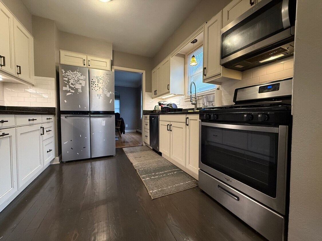
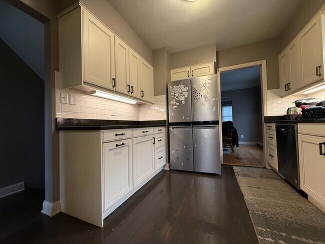
Just Listed by Joey at Housing Hub! SHORT TERM LEASE ONLY (6 MONTHS) Welcome to 1368 Pleasant Ave in beautiful St. Paul, MN! This recently remodeled 5 bedroom, 2 bathroom home offers a perfect mix of comfort, modern updates, and a prime location just minutes from downtown. Step inside to find new appliances, a brand-new boiler, a new water heater, and fresh finishes throughout. The home features two fully updated bathrooms, spacious bedrooms, and plenty of natural light. Enjoy stylish flooring, a large backyard, in-unit laundry, and off-street parking. (See photos above for a closer look at the updated interiors!) Tenant Responsibilities: - Water & Sewer - Electric & Gas - Heat - Trash ($45) - Lawn & Snow care (listed price includes the $225 lawn and snow credit) - Administration Fee ($12) Located in a quiet and friendly neighborhood, you’re minutes from some of St. Paul’s best attractions: • St. Paul Tap, Bennetts, the Nook, Shamrocks & more! • Downtown Farmers Market • Swede Hollow Park and Cafe • Mississippi Market Co-op • Xcel Energy Center, Ordway Theater, and Science Museum of Minnesota Pet-friendly with breed restrictions and applicable fees. Apply online at – application fee is $45 per adult. Requirements: 1. Preferred credit score 650+ with no past due or collections 2. No prior evictions, UDs, or judgments 3. Clear criminal background 4. Monthly income = 2.5x rent (verified) Schedule your showing today! Call or text Joey at and don’t forget to mention 1368 Pleasant Ave. This home is professionally managed by Housing Hub, offering secure online portals for rent payment and maintenance requests. All information is deemed reliable but not guaranteed.
1368 Pleasant Ave is a house located in Ramsey County and the 55102 ZIP Code. This area is served by the St. Paul Public attendance zone.
Often referred to as the “West End,” West Seventh is a convenient neighborhood located on the Riverview Corridor transit system, making travel to Downtown Saint Paul, the Minneapolis-Saint Paul Airport, and the Mall of America simple for locals.
Residents of West Seventh enjoy direct access to Interstate 35E and Xcel Energy Center. There are a plethora of amenities and attractions along the Mississippi River – from parks to historic landmarks and the High Bridge Dog Park.
Many of West Seventh’s restaurants are found along 7th Street West, like Bad Weather Brewing Company, Cossetta’s, and JR Mac’s Bar & Grill. Residents adore the proximity to the airport, and Saint Paul attractions and shopping.
Learn more about living in West Seventh| Colleges & Universities | Distance | ||
|---|---|---|---|
| Colleges & Universities | Distance | ||
| Drive: | 6 min | 2.5 mi | |
| Drive: | 8 min | 2.7 mi | |
| Drive: | 7 min | 2.7 mi | |
| Drive: | 8 min | 3.5 mi |
 The GreatSchools Rating helps parents compare schools within a state based on a variety of school quality indicators and provides a helpful picture of how effectively each school serves all of its students. Ratings are on a scale of 1 (below average) to 10 (above average) and can include test scores, college readiness, academic progress, advanced courses, equity, discipline and attendance data. We also advise parents to visit schools, consider other information on school performance and programs, and consider family needs as part of the school selection process.
Transportation options available in Saint Paul include Lexington Pkwy Station, located 2.7 miles from 1368 Pleasant Ave. 1368 Pleasant Ave is near Minneapolis-St Paul International/Wold-Chamberlain, located 5.9 miles or 12 minutes away.
| Transit / Subway | Distance | ||
|---|---|---|---|
| Transit / Subway | Distance | ||
| Drive: | 8 min | 2.7 mi | |
| Drive: | 8 min | 3.1 mi | |
| Drive: | 8 min | 3.6 mi | |
| Drive: | 9 min | 3.6 mi | |
| Drive: | 9 min | 3.7 mi |
| Commuter Rail | Distance | ||
|---|---|---|---|
| Commuter Rail | Distance | ||
|
|
Drive: | 7 min | 4.2 mi |
|
|
Drive: | 21 min | 10.0 mi |
|
|
Drive: | 28 min | 20.1 mi |
|
|
Drive: | 38 min | 28.2 mi |
|
|
Drive: | 40 min | 29.8 mi |
| Airports | Distance | ||
|---|---|---|---|
| Airports | Distance | ||
|
Minneapolis-St Paul International/Wold-Chamberlain
|
Drive: | 12 min | 5.9 mi |
Time and distance from 1368 Pleasant Ave.
| Shopping Centers | Distance | ||
|---|---|---|---|
| Shopping Centers | Distance | ||
| Drive: | 5 min | 1.8 mi | |
| Drive: | 5 min | 1.8 mi | |
| Drive: | 5 min | 2.1 mi |
| Parks and Recreation | Distance | ||
|---|---|---|---|
| Parks and Recreation | Distance | ||
|
Highland Park and Golf Course
|
Drive: | 3 min | 1.1 mi |
|
Macalester College Observatory
|
Drive: | 6 min | 2.5 mi |
|
Crosby Farm Regional Park
|
Drive: | 7 min | 3.2 mi |
|
Irvine Park
|
Drive: | 6 min | 3.3 mi |
|
Cherokee Regional Park
|
Drive: | 9 min | 3.5 mi |
| Hospitals | Distance | ||
|---|---|---|---|
| Hospitals | Distance | ||
| Drive: | 6 min | 2.6 mi | |
| Drive: | 7 min | 3.3 mi | |
| Drive: | 8 min | 3.8 mi |
| Military Bases | Distance | ||
|---|---|---|---|
| Military Bases | Distance | ||
| Drive: | 11 min | 4.7 mi |
$3,500
Total Monthly Price4 Beds, 2 Baths, 1,531 sq ft
$2,600
Total Monthly Price4 Beds, 2 Baths, 2,400 sq ft
$7,250
Total Monthly Price5 Beds, 3.5 Baths, 6,004 sq ft
$1,950
Total Monthly Price4 Beds, 2 Baths, 1,850 sq ft
$2,763 - $9,161
Total Monthly Price4 Beds
Pets Allowed Fitness Center Pool Dishwasher In Unit Washer & Dryer Walk-In Closets
$3,570 - $3,625
Total Monthly Price4 Beds
$2,645
Total Monthly Price4 Beds, 1.5 Baths, 2,272 sq ft
What Are Walk Score®, Transit Score®, and Bike Score® Ratings?
Walk Score® measures the walkability of any address. Transit Score® measures access to public transit. Bike Score® measures the bikeability of any address.
What is a Sound Score Rating?
A Sound Score Rating aggregates noise caused by vehicle traffic, airplane traffic and local sources