
$1,500
/ Month
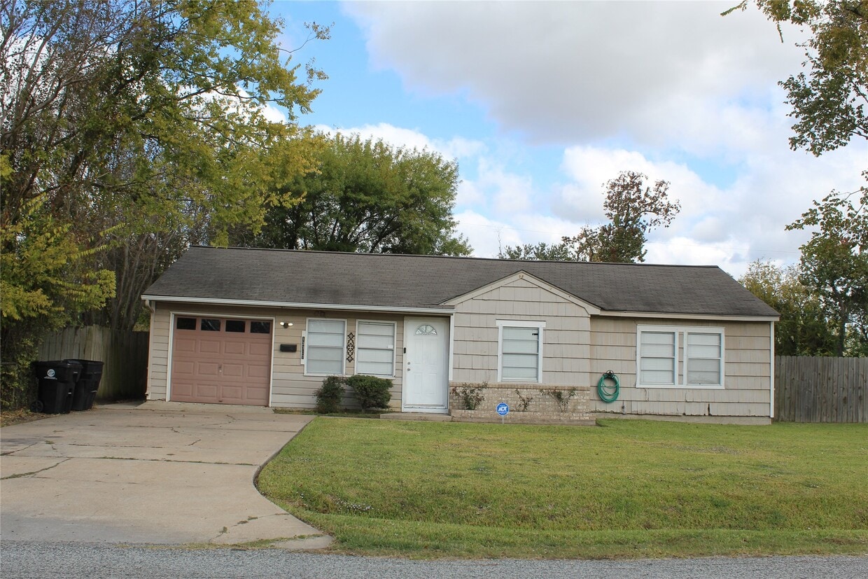
13307 Force St
Houston, TX 77015
Today
|
Edit
Favorites
713-409-2291
-
Bedrooms
3
-
Bathrooms
1
-
Square Feet
947 sq ft
-
Available
Available Now
Highlights
- Traditional Architecture
- Private Yard
- 1 Car Attached Garage
- Living Room
- Tile Flooring
- Central Heating and Cooling System
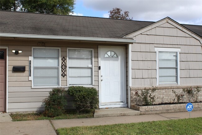
13307 Force St

Favorites
About This Home
Available Now
Welcome to this inviting 3-bedroom,1-bathroom home located in the heart of Galena Park. This property is conveniently situated just minutes from downtown Houston and offers easy access for those commuting to the ship channel or refineries in the energy sector. Inside,you’ll find a cozy vintage kitchen with plenty of potential and a spacious backyard perfect for outdoor activities. One car garage with utility room with washer and dryer connections for your convenience. The home also includes a long driveway for added parking space. This property is ideal for renters seeking comfort and convenience in a great location just 20 minutes from Downtown Houston and 20 minutes to the Energy sector in Pasadena. Don't let this one pass you by. MLS# 98189308
13307 Force St is a house located in Harris County and the 77015 ZIP Code. This area is served by the Galena Park Independent attendance zone.
* Price shown is base rent. Excludes user-selected optional fees and variable or usage-based fees and required charges due at or prior to move-in or at move-out. Price, availability, fees, and any applicable rent special are subject to change without notice.
* Square footage definitions vary. Displayed square footage is approximate.
Home Details
Home Type
Single Family Detached Home
Year Built
Built in 1954
Bedrooms and Bathrooms
1 Full Bathroom
3 Bedrooms
Flooring
Tile
Carpet
Laminate
Home Design
Traditional Architecture
Interior Spaces
Living Room
Combination Kitchen and Dining Room
947 Sq Ft Home
1-Story Property
Kitchen
Gas Oven
Gas Range
Laundry
Washer and Electric Dryer Hookup
Listing and Financial Details
Property Available on 11/17/25
12 Month Lease Term
Lot Details
9,450 Sq Ft Lot
Private Yard
South Facing Home
Parking
1 Car Attached Garage
Schools
Green Valley Elementary School
Cunningham Middle School
North Shore Senior High School
Utilities
Central Heating and Cooling System
Heating System Uses Gas
No Utilities
Community Details
Overview
Home Owned Estates Sec 02 Subdivision
Pet Policy
No Pets Allowed
Contact
- Listed by Veronica Ortega | Santana Real Estate
- Phone Number
- Contact
-
Source
 Houston Association of REALTORS®
Copyright © 2026 Houston Association of Realtors. All rights reserved. All information provided by the listing agent/broker is deemed reliable but is not guaranteed and should be independently verified.
Location
Get Directions
Northshore is a small neighborhood just over nine miles east of Downtown Houston. The neighborhood has something for everyone with rental options for every budget and style, from cozy ranches to modern apartments. Residents have access to several shopping centers, grocery stores, restaurants, and parks. Interstates 10 and 610 run through Northshore, so it’s a great option for commuters looking for a convenient location.
Learn more about living in Northshore
Education
| Colleges & Universities | Distance | ||
|---|---|---|---|
| Colleges & Universities | Distance | ||
| Drive: | 5 min | 2.2 mi | |
| Drive: | 18 min | 12.1 mi | |
| Drive: | 23 min | 13.7 mi | |
| Drive: | 23 min | 14.0 mi |
13307 Force St is within 5 minutes or 2.2 miles from San Jacinto College, North. It is also near Univ. of Houston, Downtown and University of Houston.
Schools


Public Elementary & Middle School
Grades 6
1,030 Students
Attendance Zone
Public Elementary School
Grades PK-5
598 Students
Attendance Zone
Public Middle School
Grades 7-8
928 Students
Attendance Zone
Public High School
Grades 9-12
4,569 Students
Attendance Zone
Private Elementary, Middle & High School
Grades PK-12
343 Students
Nearby
Private Elementary School
Grades PK-5
Nearby
Private Elementary School
Grades PK-1
17 Students
Nearby
Private Middle & High School
Grades 7-12
2 Students
Nearby
School data provided by
 The GreatSchools Rating helps parents compare schools within a state based on a variety of school quality indicators and provides a helpful picture of how effectively each school serves all of its students. Ratings are on a scale of 1 (below average) to 10 (above average) and can include test scores, college readiness, academic progress, advanced courses, equity, discipline and attendance data. We also advise parents to visit schools, consider other information on school performance and programs, and consider family needs as part of the school selection process.
View GreatSchools Rating Methodology
Data provided by GreatSchools.org © 2026. All rights reserved.
View GreatSchools Rating Methodology
Data provided by GreatSchools.org © 2026. All rights reserved.
Transportation options available in Houston include Cesar Chavez / 67Th St Eb, located 11.0 miles from 13307 Force St. 13307 Force St is near William P Hobby, located 17.9 miles or 31 minutes away, and George Bush Intcntl/Houston, located 22.9 miles or 30 minutes away.
| Transit / Subway | Distance | ||
|---|---|---|---|
| Transit / Subway | Distance | ||
| Drive: | 16 min | 11.0 mi | |
| Drive: | 17 min | 11.1 mi | |
| Drive: | 17 min | 11.1 mi | |
| Drive: | 17 min | 11.1 mi | |
| Drive: | 18 min | 11.8 mi |
| Commuter Rail | Distance | ||
|---|---|---|---|
| Commuter Rail | Distance | ||
|
|
Drive: | 19 min | 12.9 mi |
| Airports | Distance | ||
|---|---|---|---|
| Airports | Distance | ||
|
William P Hobby
|
Drive: | 31 min | 17.9 mi |
|
George Bush Intcntl/Houston
|
Drive: | 30 min | 22.9 mi |
Time and distance from 13307 Force St.
| Shopping Centers | Distance | ||
|---|---|---|---|
| Shopping Centers | Distance | ||
| Walk: | 7 min | 0.4 mi | |
| Walk: | 12 min | 0.6 mi | |
| Walk: | 13 min | 0.7 mi |
13307 Force St has 3 shopping centers within 0.7 mile, which is about a 13-minute walk. The miles and minutes will be for the farthest away property.
| Parks and Recreation | Distance | ||
|---|---|---|---|
| Parks and Recreation | Distance | ||
|
Gene Green All-Inclusive Park
|
Drive: | 8 min | 3.8 mi |
|
Sheldon Lake State Park
|
Drive: | 16 min | 10.5 mi |
|
Sims Bayou Urban Nature Center
|
Drive: | 20 min | 12.9 mi |
|
Baytown Nature Center
|
Drive: | 19 min | 13.1 mi |
|
San Jacinto Battleground State Historic Site
|
Drive: | 25 min | 15.0 mi |
13307 Force St has 5 parks within 15.0 miles, including Gene Green All-Inclusive Park, Sheldon Lake State Park, and Sims Bayou Urban Nature Center.
| Hospitals | Distance | ||
|---|---|---|---|
| Hospitals | Distance | ||
| Drive: | 5 min | 2.9 mi | |
| Drive: | 19 min | 12.7 mi | |
| Drive: | 20 min | 12.9 mi |
13307 Force St has 3 hospitals within 12.9 miles, the nearest is Ad Hospital East which is 2.9 miles away and a 5 minute drive.
| Military Bases | Distance | ||
|---|---|---|---|
| Military Bases | Distance | ||
| Drive: | 40 min | 23.1 mi | |
| Drive: | 70 min | 52.8 mi |
13307 Force St is 23.1 miles from Lyndon B Johnson Space Center, and is convenient to other military bases, including Pelican Spit Military Reservation.
You May Also Like
Similar Rentals Nearby
-
-

-

-

-

-
-
1 / 20

-
-
-


What Are Walk Score®, Transit Score®, and Bike Score® Ratings?
Walk Score® measures the walkability of any address. Transit Score® measures access to public transit. Bike Score® measures the bikeability of any address.
What is a Sound Score Rating?
A Sound Score Rating aggregates noise caused by vehicle traffic, airplane traffic and local sources

13307 Force St
Houston, TX 77015