$2,645
/ Month
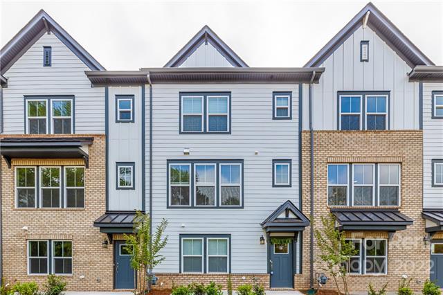
12338 Landry Renee Pl
Charlotte, NC 28277
2 Weeks Ago
|
Edit
Favorites
12338 Landry Renee Pl

Favorites
Check Back Soon for Upcoming Availability
| Beds | Baths | Average SF |
|---|---|---|
| 3 Bedrooms 3 Bedrooms 3 Br | 3.5 Baths 3.5 Baths 3.5 Ba | 2,091 SF |
About This Property
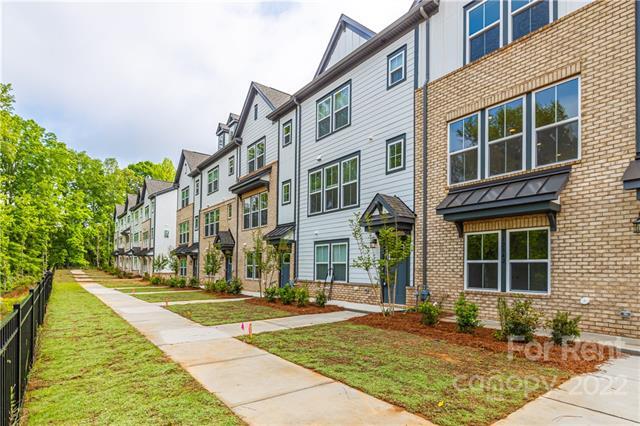
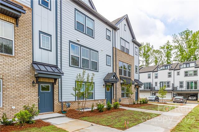
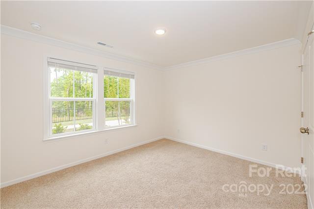
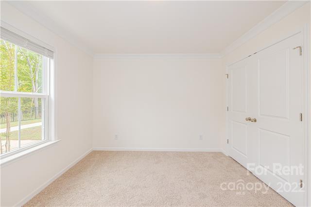
Directions: Copy, paste these coordinates in google maps 35.050657, -80.817459 Brand NEW energy-efficient Luxury Townhome with Rooftop Terrace located near Stonecrest Shopping Center in Ballantyne is Available NOW! 1st floor includes a rear entry 2 car garage, bedroom and a full bathroom. Open floor plan with living room, upgraded kitchen with many cabinets, breakfast area and a large balcony on second floor. Upstairs includes dual Master with attached bathrooms and laundry. White cabinets, quartz countertops, Cool grey EVP flooring. Gourmet Kitchen with Stainless-steel appliances, tile backsplash, gas range in kitchen. Elm at Stonecrest is in a desirable location with high rated schools, easy access to I-485, dining and entertainment areas. Water, Gas and Electricity are tenant's responsibilities. HOA fees will be paid by the owner. Every tenant above 18 years will require credit/background check/proof of funds/application fee.
12338 Landry Renee Pl is a townhome located in Mecklenburg County and the 28277 ZIP Code. This area is served by the Charlotte-Mecklenburg School District attendance zone.
12338 Landry Renee Pl,
Charlotte,
NC
28277
Sitting on the southern edge of Charlotte at the South Carolina state line, the Ballantyne neighborhood is well-known as a sought-after residential community as well as a prime shopping and dining destination. The neighborhood is anchored by a cluster of popular shopping plazas and restaurants at the intersection of Johnston Road and Ballantyne Commons Parkway, which features local favorites like Rush Espresso Cafe and Zapata’s Mexican.
The retail district is surrounded by tranquil neighborhoods full of beautiful homes and luxury apartments on gorgeous tree-lined streets. Located right alongside I-485, living in Ballantyne provides convenient access to the local highways, allowing you to easily reach anywhere in the city for work or leisure anytime.
Learn more about living in BallantyneBelow are rent ranges for similar nearby apartments
| Beds | Average Size | Lowest | Typical | Premium |
|---|---|---|---|---|
| Studio Studio Studio | 668 Sq Ft | $1,305 | $1,741 | $4,366 |
| 1 Bed 1 Bed 1 Bed | 814-815 Sq Ft | $595 | $1,760 | $6,296 |
| 2 Beds 2 Beds 2 Beds | 1220-1222 Sq Ft | $1,250 | $2,255 | $6,072 |
| 3 Beds 3 Beds 3 Beds | 1624-1626 Sq Ft | $1,499 | $2,898 | $8,620 |
| 4 Beds 4 Beds 4 Beds | 2686 Sq Ft | $2,545 | $5,126 | $19,327 |
Education
| Colleges & Universities | Distance | ||
|---|---|---|---|
| Colleges & Universities | Distance | ||
| Drive: | 15 min | 9.6 mi | |
| Drive: | 16 min | 10.3 mi | |
| Drive: | 23 min | 12.2 mi | |
| Drive: | 24 min | 15.5 mi |
12338 Landry Renee Pl is within 16 minutes or 10.3 miles from Central Piedmont C.C., Levine. It is also near Central Piedmont C.C., Harper and Queens University of Charlotte.
Schools


Public Elementary School
Grades PK-5
689 Students
Nearby
Public Elementary School
Grades K-5
737 Students
Attendance Zone
Public Middle School
Grades 6-8
1,305 Students
Attendance Zone
Public High School
Grades 9-12
3,529 Students
Attendance Zone
Private Elementary, Middle & High School
Grades PK-12
167 Students
Nearby
Private Elementary, Middle & High School
Grades PK-12
191 Students
Nearby
Private Elementary & Middle School
Grades PK-8
176 Students
Nearby
Private Elementary School
Grades K-5
614 Students
Nearby
School data provided by
 The GreatSchools Rating helps parents compare schools within a state based on a variety of school quality indicators and provides a helpful picture of how effectively each school serves all of its students. Ratings are on a scale of 1 (below average) to 10 (above average) and can include test scores, college readiness, academic progress, advanced courses, equity, discipline and attendance data. We also advise parents to visit schools, consider other information on school performance and programs, and consider family needs as part of the school selection process.
View GreatSchools Rating Methodology
Data provided by GreatSchools.org © 2026. All rights reserved.
View GreatSchools Rating Methodology
Data provided by GreatSchools.org © 2026. All rights reserved.
Transportation options available in Charlotte include I-485/South Boulevard, located 7.3 miles from 12338 Landry Renee Pl. 12338 Landry Renee Pl is near Charlotte/Douglas International, located 16.6 miles or 26 minutes away, and Concord-Padgett Regional, located 34.2 miles or 42 minutes away.
| Transit / Subway | Distance | ||
|---|---|---|---|
| Transit / Subway | Distance | ||
|
|
Drive: | 10 min | 7.3 mi |
|
|
Drive: | 12 min | 8.2 mi |
|
|
Drive: | 13 min | 9.2 mi |
|
|
Drive: | 16 min | 10.4 mi |
|
|
Drive: | 17 min | 11.2 mi |
| Commuter Rail | Distance | ||
|---|---|---|---|
| Commuter Rail | Distance | ||
|
|
Drive: | 28 min | 15.6 mi |
|
|
Drive: | 41 min | 31.5 mi |
| Drive: | 55 min | 44.8 mi |
| Airports | Distance | ||
|---|---|---|---|
| Airports | Distance | ||
|
Charlotte/Douglas International
|
Drive: | 26 min | 16.6 mi |
|
Concord-Padgett Regional
|
Drive: | 42 min | 34.2 mi |
Walkability Near 12338 Landry Renee Pl Charlotte, NC 28277
Getting Around
 What do Walkability, Transit, Drivability, and Bikeability mean?
Walkability measures the walking distance to day-to-day needs.
Transit measures access to public transportation.
Drivability measures congestion, parking availability, and access to major roads.
Bikeability measures the suitability for cycling.
How It Works
What do Walkability, Transit, Drivability, and Bikeability mean?
Walkability measures the walking distance to day-to-day needs.
Transit measures access to public transportation.
Drivability measures congestion, parking availability, and access to major roads.
Bikeability measures the suitability for cycling.
How It Works
Fairly Walkable
Walkability
50
/ 100
Limited Public Transit
Transit
30
/ 100
Exceptionally Drivable
Drivability
90
/ 100
Fairly Bikeable
Bikeability
50
/ 100
Scores provided by
-
Soundscore™
-
/ 100
Traffic
-Airport
-Businesses
-Scores provided by
HowLoud What is a Sound Score Rating? A Sound Score Rating aggregates noise caused by vehicle traffic, airplane traffic and local sources. How It WorksTime and distance from 12338 Landry Renee Pl.
| Shopping Centers | Distance | ||
|---|---|---|---|
| Shopping Centers | Distance | ||
| Walk: | 6 min | 0.3 mi | |
| Walk: | 7 min | 0.4 mi | |
| Walk: | 18 min | 1.0 mi |
12338 Landry Renee Pl has 3 shopping centers within 1.0 mile, which is about a 18-minute walk. The miles and minutes will be for the farthest away property.
| Parks and Recreation | Distance | ||
|---|---|---|---|
| Parks and Recreation | Distance | ||
|
Ballantyne's Backyard
|
Drive: | 6 min | 2.3 mi |
|
Stream Park
|
Drive: | 6 min | 2.8 mi |
|
Brixham Park
|
Drive: | 6 min | 3.1 mi |
|
Marvin Efird Park
|
Drive: | 15 min | 7.1 mi |
|
Stallings Municipal Park
|
Drive: | 13 min | 9.7 mi |
12338 Landry Renee Pl has 5 parks within 9.7 miles, including Ballantyne's Backyard, Stream Park, and Brixham Park.
| Hospitals | Distance | ||
|---|---|---|---|
| Hospitals | Distance | ||
| Drive: | 4 min | 2.5 mi | |
| Drive: | 9 min | 6.1 mi | |
| Drive: | 12 min | 8.4 mi |
12338 Landry Renee Pl has 3 hospitals within 8.4 miles, the nearest is Novant Health Ballantyne Medical Center which is 2.5 miles away and a 4 minute drive.
| Military Bases | Distance | ||
|---|---|---|---|
| Military Bases | Distance | ||
| Drive: | 127 min | 89.9 mi |
12338 Landry Renee Pl is 89.9 miles and a 127 minute drive from Fort Jackson.
You May Also Like
-
One West End
2701 Rozzelles Ferry Rd
Charlotte, NC 28208
$2,249 - $2,749
3 Br 14.0 mi
-
NOVEL University Place by Crescent Communities
5315 Waters Edge Village Dr
Charlotte, NC 28262
$3,032 - $4,000 Total Monthly Price
3 Br 18.4 mi
-
University Townhomes at Charlotte
10035 Dabney Dr
Charlotte, NC 28262
$635 - $845
3-4 Br 18.9 mi
Similar Rentals Nearby
-
-
3 Beds$3,064+Total Monthly PriceTotal Monthly Price NewPrices include base rent and required monthly fees of $59. Variable costs based on usage may apply.Base Rent:3 Beds$3,005+Specials
Pets Allowed Fitness Center Dishwasher Refrigerator Kitchen In Unit Washer & Dryer
-
-
3 Beds$2,199+Total Monthly PriceTotal Monthly Price NewPrices include all required monthly fees.Specials
Pets Allowed Dishwasher Refrigerator Walk-In Closets Maintenance on site CableReady
-
-
-
-
-
-
3 Beds$3,117Total Monthly PriceTotal Monthly Price NewPrices include required monthly fees of $123.Base Rent:3 Beds$2,9942 Months Free
Pets Allowed Fitness Center Pool Kitchen In Unit Washer & Dryer Walk-In Closets Balcony


What Are Walk Score®, Transit Score®, and Bike Score® Ratings?
Walk Score® measures the walkability of any address. Transit Score® measures access to public transit. Bike Score® measures the bikeability of any address.
What is a Sound Score Rating?
A Sound Score Rating aggregates noise caused by vehicle traffic, airplane traffic and local sources.

12338 Landry Renee Pl
Charlotte, NC 28277