
$1,395
/ Month
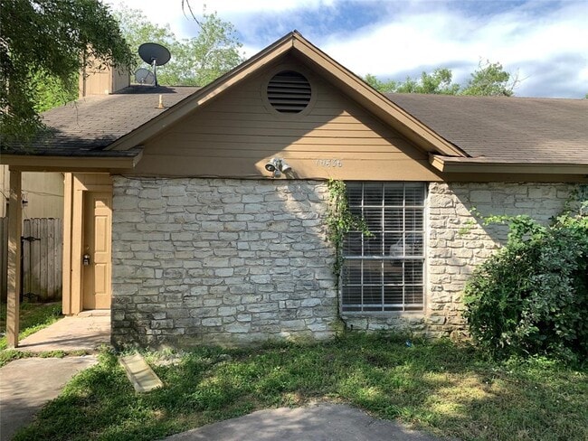
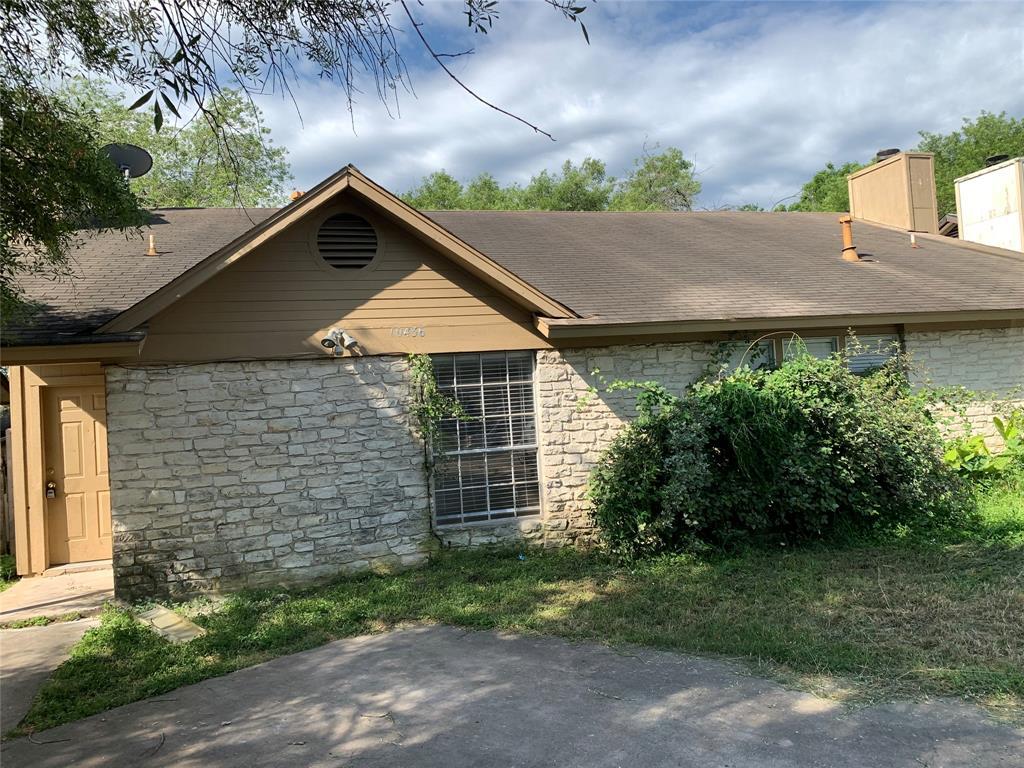
10436 Doc Holliday Trail
Austin, TX 78753
Today
|
Edit
Favorites
512-655-9538
-
Bedrooms
2
-
Bathrooms
2
-
Square Feet
2,008 sq ft
-
Available
Available Now
Highlights
- Wooded Lot
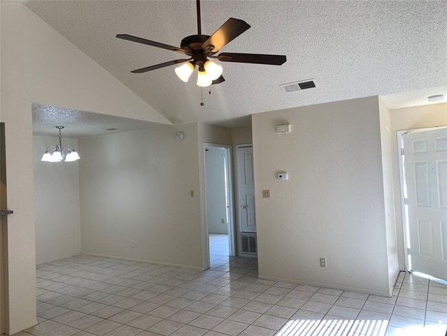
- Tile Flooring
- 1-Story Property
- Central Heating and Cooling System
- Dogs and Cats Allowed
- North Facing Home
10436 Doc Holliday Trail

Favorites
About This Home
Available Now
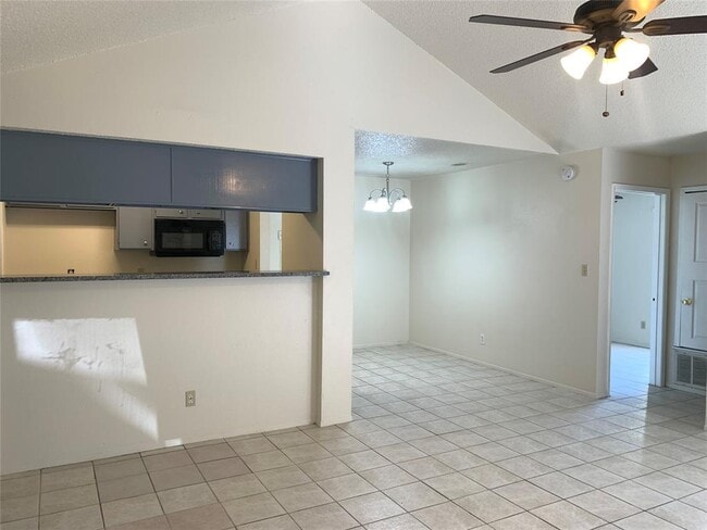
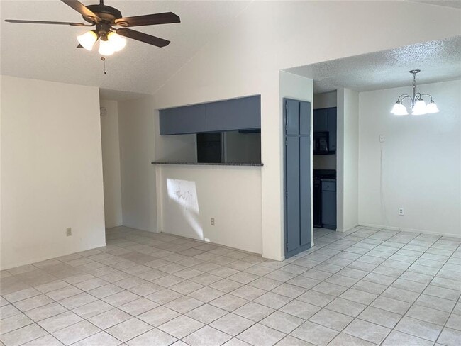
Move-In Ready! Bright and clean Duplex, tile floors throughout. Granite Kitchen counters, Dining area. Large and private fenced backyard with patio. Washer/dryer hookups within unit. Great location! Close to malls, restaurants, & I-35. Just 11 miles North of Downtown Austin.
10436 Doc Holliday Trail is a townhome located in Travis County and the 78753 ZIP Code. This area is served by the Austin Independent attendance zone.
* Price shown is base rent. Excludes user-selected optional fees and variable or usage-based fees and required charges due at or prior to move-in or at move-out. Price, availability, fees, and any applicable rent special are subject to change without notice.
* Square footage definitions vary. Displayed square footage is approximate.
Home Details
Home Type
Duplex
Year Built
Built in 1982
Bedrooms and Bathrooms
2 Main Level Bedrooms
2 Full Bathrooms
Home Design
Composition Roof
Slab Foundation
Interior Spaces
Family Room with Fireplace
Tile Flooring
1-Story Property
2,008 Sq Ft Home
Blinds
Kitchen
Gas Range
Oven
Free-Standing Range
Microwave
Dishwasher
Disposal
Listing and Financial Details
Security Deposit $1,395
12 Month Lease Term
$75 Application Fee
Assessor Parcel Number 02442013370000
Tenant pays for all utilities
The owner pays for taxes
Lot Details
Wooded Lot
North Facing Home
Privacy Fence
Fenced
Parking
2 Car Garage
Front Facing Garage
Schools
Walnut Creek Elementary School
Dobie Middle School
Navarro Early College High School
Utilities
Central Heating and Cooling System
Community Details
Overview
2 Units
No Home Owners Association
Property managed by Total Realty Texas
Western Trails Of Quail Creeks Subdivision
Pet Policy
Dogs and Cats Allowed
Breed Restrictions
Medium pets allowed
Pet Deposit $400
Fees and Policies
The fees below are based on community-supplied data and may exclude additional fees and utilities.
- Dogs
- Allowed
- Cats
- Allowed
Property Fee Disclaimer: Based on community-supplied data and independent market research. Subject to change without notice. May exclude fees for mandatory or optional services and usage-based utilities.
Contact
- Listed by Wendy Chen | Total Realty Texas
- Phone Number
- Contact
-
Source
 Austin Board of REALTORS®
The information included in this listing is provided exclusively for consumers’ personal, non-commercial use and may not be used for any purpose other than to identify prospective properties consumers may be interested in purchasing. The information on each listing is furnished by the owner and deemed reliable to the best of his/her knowledge, but should be verified by the purchaser. ABoR, ACTRIS and Estately assume no responsibility for typographical errors, misprints or misinformation. This property listing is offered without respect to any protected classes in accordance with the law. Copyright © 2025.
Location
Get Directions
Amenities
- Dishwasher
- Disposal
- Microwave
- Refrigerator
- Tile Floors
About eight miles north of Downtown Austin, North Lamar is a quiet suburban neighborhood nestled along Interstate 35, taking you directly into everything that Austin is known for. Discover delicious restaurants, lively bars, museums, historic sites, and more just minutes from North Lamar. Commuters enjoy the easy travel to and from Austin, while also appreciating the secluded appeal of North Lamar.
With affordable rentals spanning across cozy single-family homes and various apartment communities, the options are reasonable in North Lamar. Supermarkets, restaurants, and community parks can be found in this neighborhood, with more dining and entertainment options lying just outside of town in neighboring areas. Along Interstate 35, locals have access to numerous businesses and services from car shops to storage facilities.
Learn more about living in North Lamar
Education
| Colleges & Universities | Distance | ||
|---|---|---|---|
| Colleges & Universities | Distance | ||
| Drive: | 8 min | 3.7 mi | |
| Drive: | 11 min | 7.1 mi | |
| Drive: | 13 min | 8.5 mi | |
| Drive: | 14 min | 8.6 mi |
10436 Doc Holliday Trail is within 8 minutes or 3.7 miles from Austin C.C., Northridge Campus. It is also near University of Texas at Austin and Austin C.C., Rio Grande Campus.
Schools


Public Elementary School
Grades PK-5
545 Students
Attendance Zone
Public Middle School
Grades 6-8
618 Students
Attendance Zone
Public High School
Grades 9-12
1,649 Students
Attendance Zone
Private Elementary & Middle School
Grades K-8
8 Students
Nearby
Private Elementary, Middle & High School
Grades K-12
Nearby
Private Elementary, Middle & High School
Grades PK-12
651 Students
Nearby
School data provided by
 The GreatSchools Rating helps parents compare schools within a state based on a variety of school quality indicators and provides a helpful picture of how effectively each school serves all of its students. Ratings are on a scale of 1 (below average) to 10 (above average) and can include test scores, college readiness, academic progress, advanced courses, equity, discipline and attendance data. We also advise parents to visit schools, consider other information on school performance and programs, and consider family needs as part of the school selection process.
View GreatSchools Rating Methodology
Data provided by GreatSchools.org © 2025. All rights reserved.
View GreatSchools Rating Methodology
Data provided by GreatSchools.org © 2025. All rights reserved.
Transportation options available in Austin include Crestview Station, located 3.3 miles from 10436 Doc Holliday Trail. 10436 Doc Holliday Trail is near Austin-Bergstrom International, located 18.6 miles or 30 minutes away.
| Transit / Subway | Distance | ||
|---|---|---|---|
| Transit / Subway | Distance | ||
| Drive: | 7 min | 3.3 mi | |
| Drive: | 7 min | 3.4 mi | |
| Drive: | 8 min | 3.7 mi | |
| Drive: | 7 min | 4.0 mi | |
| Drive: | 12 min | 6.6 mi |
| Commuter Rail | Distance | ||
|---|---|---|---|
| Commuter Rail | Distance | ||
|
|
Drive: | 16 min | 9.7 mi |
|
|
Drive: | 40 min | 26.2 mi |
| Airports | Distance | ||
|---|---|---|---|
| Airports | Distance | ||
|
Austin-Bergstrom International
|
Drive: | 30 min | 18.6 mi |
Time and distance from 10436 Doc Holliday Trail.
| Shopping Centers | Distance | ||
|---|---|---|---|
| Shopping Centers | Distance | ||
| Walk: | 9 min | 0.5 mi | |
| Walk: | 16 min | 0.9 mi | |
| Walk: | 17 min | 0.9 mi |
10436 Doc Holliday Trail has 3 shopping centers within 0.9 mile, which is about a 17-minute walk. The miles and minutes will be for the farthest away property.
| Parks and Recreation | Distance | ||
|---|---|---|---|
| Parks and Recreation | Distance | ||
|
Walnut Creek Park
|
Drive: | 5 min | 2.5 mi |
|
Jourdan-Bachman Pioneer Farms
|
Drive: | 8 min | 3.9 mi |
|
Copperfield Nature Trail and Park
|
Drive: | 9 min | 4.5 mi |
|
The Stephen F. Austin Planetarium
|
Drive: | 10 min | 4.7 mi |
|
Balcones District Park
|
Drive: | 11 min | 5.0 mi |
10436 Doc Holliday Trail has 5 parks within 5.0 miles, including Walnut Creek Park, Jourdan-Bachman Pioneer Farms, and Copperfield Nature Trail and Park.
| Hospitals | Distance | ||
|---|---|---|---|
| Hospitals | Distance | ||
| Drive: | 6 min | 2.9 mi | |
| Drive: | 9 min | 4.6 mi | |
| Drive: | 11 min | 5.5 mi |
10436 Doc Holliday Trail has 3 hospitals within 5.5 miles, the nearest is Cross Creek Hospital which is 2.9 miles away and a 6 minute drive.
| Military Bases | Distance | ||
|---|---|---|---|
| Military Bases | Distance | ||
| Drive: | 84 min | 67.7 mi | |
| Drive: | 89 min | 73.8 mi |
10436 Doc Holliday Trail is 67.7 miles from Fort Hood, and is convenient to other military bases, including Randolph Air Force Base.
You May Also Like
Similar Rentals Nearby


What Are Walk Score®, Transit Score®, and Bike Score® Ratings?
Walk Score® measures the walkability of any address. Transit Score® measures access to public transit. Bike Score® measures the bikeability of any address.
What is a Sound Score Rating?
A Sound Score Rating aggregates noise caused by vehicle traffic, airplane traffic and local sources
10436 Doc Holliday Trail
Austin, TX 78753