
$2,000
/ Month
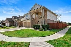
10102 San Ignacio
Houston, TX 77075
1 Day Ago
|
Edit
Favorites
713-240-8812
-
Bedrooms
4
-
Bathrooms
3
-
Square Feet
2,304 sq ft
-
Available
Available Now
Highlights
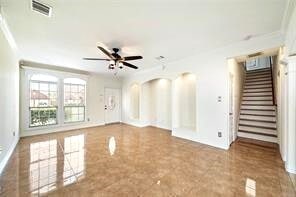
- Contemporary Architecture
- Corner Lot
- Breakfast Room
- 2 Car Attached Garage
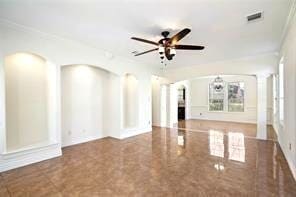
- Crown Molding
- Living Room
10102 San Ignacio

Favorites
About This Home
Available Now
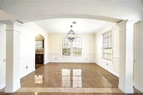
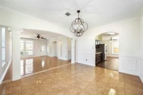
This is nice and well-maintained two-story home. This home has recently been updated tile on the 1st floor,customed crown molding... Ready to move in by December 1st,2025 MLS# 8052097
10102 San Ignacio is a house located in Harris County and the 77075 ZIP Code. This area is served by the Pasadena Independent attendance zone.
* Price shown is base rent. Excludes user-selected optional fees and variable or usage-based fees and required charges due at or prior to move-in or at move-out. Price, availability, fees, and any applicable rent special are subject to change without notice.
* Square footage definitions vary. Displayed square footage is approximate.
Home Details
Home Type
Single Family Detached Home
Year Built
Built in 2002
Bedrooms and Bathrooms
2.5 Bathrooms
4 Bedrooms
Flooring
Tile
Carpet
Home Design
Contemporary Architecture
Interior Spaces
Breakfast Room
Crown Molding
Living Room
Dining Room
2,304 Sq Ft Home
2-Story Property
Kitchen
Gas Range
Dishwasher
Disposal
Laundry
Washer and Gas Dryer Hookup
Listing and Financial Details
Property Available on 12/1/25
Long Term Lease
Lot Details
5,488 Sq Ft Lot
Corner Lot
Back Yard Fenced
Parking
2 Car Attached Garage
Schools
Hancock Elementary School
Morris Middle School
South Houston High School
Utilities
Central Heating and Cooling System
Heating System Uses Gas
Community Details
Overview
South University Place Subdivision
Pet Policy
No Pets Allowed
Contact
- Listed by Dominic Vu | HomePro Realty,Inc
- Phone Number
- Contact
-
Source
 Houston Association of REALTORS®
Copyright © 2025 Houston Association of Realtors. All rights reserved. All information provided by the listing agent/broker is deemed reliable but is not guaranteed and should be independently verified.
Location
Get Directions
Southbelt Ellington is a large neighborhood located about 20 miles southeast of Downtown Houston. Southbelt Ellington is known as one of the best neighborhoods to live in the city. Residents in this suburban, family-friendly area have access to good schools, parks, and plenty of amenities. Locals flock to Gulf Freeway for restaurants, wholesale clubs, and shopping centers like Almeda Mall. Great for any renter, Southbelt Ellington has various affordable and upscale rental options available.
The neighborhood is also known for being home to the Ellington Field Joint Reserve Base, which dominates the western side of Southbelt Ellington. Interstate 45 and Highway 8 intersect, making traveling into Downtown Houston and other neighborhoods easy. Whether residents commute to work or stay home, Southbelt-Ellington provides a home base with a well-rounded community feel.
Learn more about living in Southbelt-Ellington
Education
| Colleges & Universities | Distance | ||
|---|---|---|---|
| Colleges & Universities | Distance | ||
| Drive: | 12 min | 4.4 mi | |
| Drive: | 18 min | 10.0 mi | |
| Drive: | 21 min | 11.6 mi | |
| Drive: | 19 min | 11.8 mi |
10102 San Ignacio is within 12 minutes or 4.4 miles from San Jacinto College, South. It is also near San Jacinto College, Central and University of Houston.
Schools


Public Elementary School
Grades PK-4
406 Students
Attendance Zone
Public Elementary School
Grades 5-6
703 Students
Attendance Zone
Public Middle School
Grades 7-8
852 Students
Attendance Zone
Public High School
Grades 9-12
2,213 Students
Attendance Zone
Private Elementary, Middle & High School
Grades PK-12
Nearby
Private Elementary, Middle & High School
Grades 2-11
Nearby
Private Elementary & Middle School
Grades PK-8
35 Students
Nearby
Private Elementary School
Grades PK-3
44 Students
Nearby
School data provided by
 The GreatSchools Rating helps parents compare schools within a state based on a variety of school quality indicators and provides a helpful picture of how effectively each school serves all of its students. Ratings are on a scale of 1 (below average) to 10 (above average) and can include test scores, college readiness, academic progress, advanced courses, equity, discipline and attendance data. We also advise parents to visit schools, consider other information on school performance and programs, and consider family needs as part of the school selection process.
View GreatSchools Rating Methodology
Data provided by GreatSchools.org © 2025. All rights reserved.
View GreatSchools Rating Methodology
Data provided by GreatSchools.org © 2025. All rights reserved.
Transportation options available in Houston include Palm Center Transit Ctr Sb, located 10.2 miles from 10102 San Ignacio. 10102 San Ignacio is near William P Hobby, located 4.2 miles or 12 minutes away, and George Bush Intcntl/Houston, located 34.4 miles or 44 minutes away.
| Transit / Subway | Distance | ||
|---|---|---|---|
| Transit / Subway | Distance | ||
| Drive: | 16 min | 10.2 mi | |
| Drive: | 17 min | 10.3 mi | |
| Drive: | 17 min | 10.3 mi | |
| Drive: | 17 min | 10.7 mi | |
| Drive: | 17 min | 10.8 mi |
| Commuter Rail | Distance | ||
|---|---|---|---|
| Commuter Rail | Distance | ||
|
|
Drive: | 21 min | 14.7 mi |
| Airports | Distance | ||
|---|---|---|---|
| Airports | Distance | ||
|
William P Hobby
|
Drive: | 12 min | 4.2 mi |
|
George Bush Intcntl/Houston
|
Drive: | 44 min | 34.4 mi |
Time and distance from 10102 San Ignacio.
| Shopping Centers | Distance | ||
|---|---|---|---|
| Shopping Centers | Distance | ||
| Walk: | 7 min | 0.4 mi | |
| Walk: | 8 min | 0.4 mi | |
| Walk: | 8 min | 0.4 mi |
10102 San Ignacio has 3 shopping centers within 0.4 mile, which is about a 8-minute walk. The miles and minutes will be for the farthest away property.
| Parks and Recreation | Distance | ||
|---|---|---|---|
| Parks and Recreation | Distance | ||
|
Sims Bayou Urban Nature Center
|
Drive: | 11 min | 5.9 mi |
|
Space Center Houston
|
Drive: | 20 min | 12.3 mi |
|
NASA-Johnson Space Center
|
Drive: | 22 min | 13.1 mi |
|
Armand Bayou Nature Center
|
Drive: | 22 min | 13.6 mi |
10102 San Ignacio has 4 parks within 13.6 miles, including Sims Bayou Urban Nature Center, Armand Bayou Nature Center, and Space Center Houston.
| Hospitals | Distance | ||
|---|---|---|---|
| Hospitals | Distance | ||
| Drive: | 10 min | 3.8 mi | |
| Drive: | 11 min | 5.4 mi | |
| Drive: | 11 min | 5.7 mi |
10102 San Ignacio has 3 hospitals within 5.7 miles, the nearest is Memorial Hermann Southeast Hospital which is 3.8 miles away and a 10 minute drive.
| Military Bases | Distance | ||
|---|---|---|---|
| Military Bases | Distance | ||
| Drive: | 22 min | 13.1 mi | |
| Drive: | 51 min | 38.6 mi |
10102 San Ignacio is 13.1 miles from Lyndon B Johnson Space Center, and is convenient to other military bases, including Pelican Spit Military Reservation.
You May Also Like
Similar Rentals Nearby


What Are Walk Score®, Transit Score®, and Bike Score® Ratings?
Walk Score® measures the walkability of any address. Transit Score® measures access to public transit. Bike Score® measures the bikeability of any address.
What is a Sound Score Rating?
A Sound Score Rating aggregates noise caused by vehicle traffic, airplane traffic and local sources

10102 San Ignacio
Houston, TX 77075