
Woodland Station Apartments
1940 Washington St,
Newton, MA 02461
$3,414 - $6,201 Total Monthly Price
1-3 Beds
Bedrooms
Studio - 2 bd
Bathrooms
1 ba
Square Feet
494 - 790 sq ft
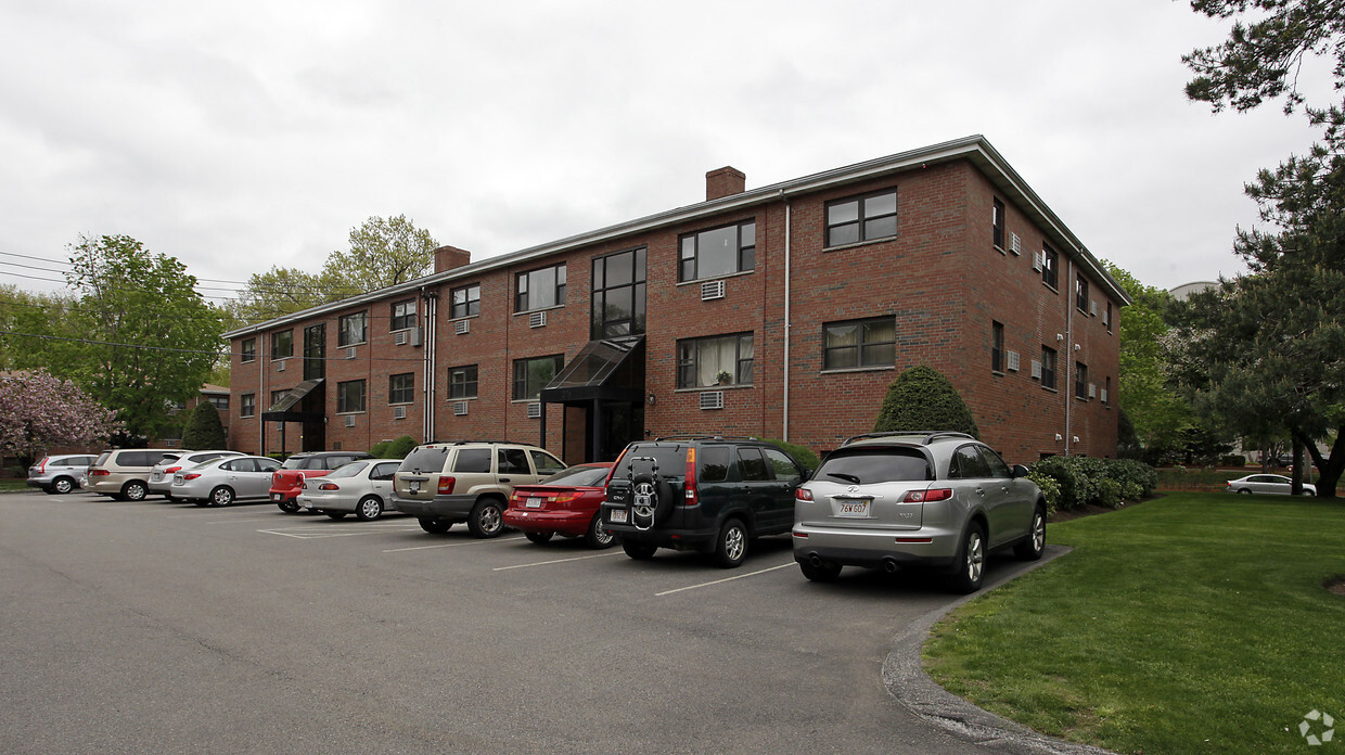
Woodland Park is a distinctive community consisting of 126 units situated on 7 acres in Newton, Massachusetts. Woodland Park features 8 separate brick buildings with a mix of studios, one bedroom and two bedroom apartments. Additionally, this property offers residents ample parking with roughly 160 spaces and is strategically situated directly across the street from the Green Line Riverside MBTA station. Woodland Park showcases a truly unmatched location; not only is the property near the Mass Pike (I-90) and Route 128 (I-95) interchange, but the Riverside Green Line MBTA station is steps away, 0.2 miles and a 4-minute walk specifically. This advantageously located asset provides residents incredible access to local submarket amenities and deep employer base and is only a 12-mile drive or a quick train ride to Downtown Boston.
Woodland Park is an apartment community located in Middlesex County and the 02466 ZIP Code. This area is served by the Newton School District attendance zone.
Auburndale, affectionately referred to as “The Dale” by locals, is one of 13 villages in the City of Newton. Situated near the intersection of Interstates 90 and 95, the Dale is surrounded by the City of Waltham and the Charles River as well as three other Newton villages including West Newton, Waban, and Newton Lower Falls. Getting around from the Dale is simple with access to the MBTA commuter rail.
The western end of Auburndale is well known for containing two historic parks, Norumbega Park and the Auburndale Cove Park and Playground, which offer plenty of options for outdoor recreation. The Auburndale Historic District is comprised of about 275 properties, many of which are on the National Register of Historic Places. Treasured resources like the Auburndale Community Library and Lasell College provide learning opportunities for the community.
Learn more about living in Auburndale| Colleges & Universities | Distance | ||
|---|---|---|---|
| Colleges & Universities | Distance | ||
| Drive: | 8 min | 3.2 mi | |
| Drive: | 10 min | 4.4 mi | |
| Drive: | 11 min | 4.6 mi | |
| Drive: | 11 min | 5.5 mi |


Transportation options available in Auburndale include Riverside Station, located 0.2 mile from Woodland Park. Woodland Park is near General Edward Lawrence Logan International, located 14.5 miles or 24 minutes away, and Worcester Regional, located 38.7 miles or 55 minutes away.
| Transit / Subway | Distance | ||
|---|---|---|---|
| Transit / Subway | Distance | ||
|
|
Walk: | 3 min | 0.2 mi |
|
|
Drive: | 4 min | 1.7 mi |
|
|
Drive: | 5 min | 2.4 mi |
|
|
Drive: | 8 min | 3.4 mi |
|
|
Drive: | 8 min | 3.6 mi |
| Commuter Rail | Distance | ||
|---|---|---|---|
| Commuter Rail | Distance | ||
|
|
Drive: | 5 min | 1.8 mi |
|
|
Drive: | 5 min | 2.5 mi |
|
|
Drive: | 6 min | 2.8 mi |
|
|
Drive: | 12 min | 6.7 mi |
|
|
Drive: | 13 min | 7.5 mi |
| Airports | Distance | ||
|---|---|---|---|
| Airports | Distance | ||
|
General Edward Lawrence Logan International
|
Drive: | 24 min | 14.5 mi |
|
Worcester Regional
|
Drive: | 55 min | 38.7 mi |
Scores provided by
Traffic
ActiveAirport
CalmBusinesses
CalmScores provided by
HowLoud What is a Sound Score Rating? A Sound Score Rating aggregates noise caused by vehicle traffic, airplane traffic and local sources. How It WorksTime and distance from Woodland Park.
| Shopping Centers | Distance | ||
|---|---|---|---|
| Shopping Centers | Distance | ||
| Walk: | 18 min | 1.0 mi | |
| Drive: | 5 min | 2.7 mi | |
| Drive: | 6 min | 2.7 mi |
| Parks and Recreation | Distance | ||
|---|---|---|---|
| Parks and Recreation | Distance | ||
|
Land's Sake Farm
|
Drive: | 8 min | 3.8 mi |
|
Hemlock Gorge Reservation
|
Drive: | 8 min | 3.9 mi |
|
Whitin Observatory
|
Drive: | 10 min | 4.4 mi |
|
Cutler Park Reservation
|
Drive: | 8 min | 4.6 mi |
|
Hammond Pond Reservation
|
Drive: | 10 min | 5.1 mi |
| Hospitals | Distance | ||
|---|---|---|---|
| Hospitals | Distance | ||
| Drive: | 3 min | 1.4 mi | |
| Drive: | 7 min | 3.0 mi | |
| Drive: | 10 min | 5.3 mi |
| Military Bases | Distance | ||
|---|---|---|---|
| Military Bases | Distance | ||
| Drive: | 15 min | 8.0 mi | |
| Drive: | 19 min | 10.4 mi | |
| Drive: | 49 min | 27.5 mi |
Pets Allowed Maintenance on site Heat Controlled Access Elevator Laundry Facilities
Pets Allowed Fitness Center In Unit Washer & Dryer Balcony Elevator Rooftop Deck
Pets Allowed Fitness Center Pool Dishwasher Kitchen In Unit Washer & Dryer
Pets Allowed Fitness Center Pool Clubhouse Balcony Stainless Steel Appliances Granite Countertops
Pets Allowed Fitness Center Pool Dishwasher Refrigerator Kitchen
What Are Walk Score®, Transit Score®, and Bike Score® Ratings?
Walk Score® measures the walkability of any address. Transit Score® measures access to public transit. Bike Score® measures the bikeability of any address.
What is a Sound Score Rating?
A Sound Score Rating aggregates noise caused by vehicle traffic, airplane traffic and local sources.

264 Grove St
Auburndale, MA 02466


