
The Bosk Apartment Homes
6850 Ashwood Rd,
Woodbury, MN 55125
$1,448 - $1,963 Total Monthly Price
1-2 Beds

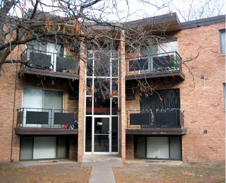
Explore your new apartment at Western Hills in Maplewood, MN. Located at 1760 Adolphus St. N in Maplewood, this community is an ideal place for residents. Make a visit to check out the apartment floorplan options. Enjoy a wide selection of amenities at this community. These include: security systems, high-speed internet access, and smoke free options. Visit Western Hills today.
Western Hills is an apartment community located in Ramsey County and the 55117 ZIP Code. This area is served by the Roseville Public School District attendance zone.
Air Conditioning
Dishwasher
High Speed Internet Access
Refrigerator
Maplewood is where the 3M Corporation chose to plant its global headquarters — and it’s easy to see why the city made such a strong impression. Sitting just ten minutes from downtown Saint Paul and stretching along its northern and eastern borders, Maplewood delivers a quieter pace without cutting you off from the Twin Cities. Battle Creek Regional Park connects cyclists directly to Saint Paul and Minneapolis through well-maintained trails, while Keller Golf Course gives outdoor enthusiasts a local retreat. The Maplewood Mall anchors a solid stretch of retail and dining options, and the live music venue Myth draws big-name acts right to the suburbs.
Renters will find a solid mix of apartment communities and townhomes spread across the city’s 19 square miles. Whether you’re after a spacious two-bedroom or a cozy studio, the rental landscape here covers a wide range of layouts and price points.
Learn more about living in Maplewood| Colleges & Universities | Distance | ||
|---|---|---|---|
| Colleges & Universities | Distance | ||
| Drive: | 6 min | 4.0 mi | |
| Drive: | 7 min | 4.3 mi | |
| Drive: | 12 min | 5.0 mi | |
| Drive: | 13 min | 7.4 mi |


Transportation options available in Maplewood include Robert St Station, located 3.1 miles from Western Hills. Western Hills is near Minneapolis-St Paul International/Wold-Chamberlain, located 12.8 miles or 21 minutes away.
| Transit / Subway | Distance | ||
|---|---|---|---|
| Transit / Subway | Distance | ||
| Drive: | 5 min | 3.1 mi | |
| Drive: | 6 min | 3.3 mi | |
| Drive: | 6 min | 3.3 mi | |
| Drive: | 6 min | 3.3 mi | |
| Drive: | 7 min | 3.9 mi |
| Commuter Rail | Distance | ||
|---|---|---|---|
| Commuter Rail | Distance | ||
|
|
Drive: | 6 min | 3.4 mi |
|
|
Drive: | 22 min | 12.5 mi |
|
|
Drive: | 19 min | 14.0 mi |
|
|
Drive: | 29 min | 22.1 mi |
|
|
Drive: | 30 min | 23.8 mi |
| Airports | Distance | ||
|---|---|---|---|
| Airports | Distance | ||
|
Minneapolis-St Paul International/Wold-Chamberlain
|
Drive: | 21 min | 12.8 mi |
Scores provided by
Traffic
-Airport
-Businesses
-Scores provided by
HowLoud What is a Sound Score Rating? A Sound Score Rating aggregates noise caused by vehicle traffic, airplane traffic and local sources. How It WorksTime and distance from Western Hills.
| Shopping Centers | Distance | ||
|---|---|---|---|
| Shopping Centers | Distance | ||
| Walk: | 16 min | 0.9 mi | |
| Walk: | 18 min | 1.0 mi | |
| Walk: | 20 min | 1.0 mi |
| Parks and Recreation | Distance | ||
|---|---|---|---|
| Parks and Recreation | Distance | ||
|
Arlington/Arkwright Park
|
Walk: | 20 min | 1.0 mi |
|
Phelan Regional Park
|
Drive: | 5 min | 2.1 mi |
|
Phalen Park
|
Drive: | 6 min | 2.2 mi |
|
Keller Regional Park
|
Drive: | 6 min | 2.4 mi |
|
Harriet Alexander Nature Center
|
Drive: | 7 min | 3.6 mi |
| Hospitals | Distance | ||
|---|---|---|---|
| Hospitals | Distance | ||
| Drive: | 5 min | 2.9 mi | |
| Drive: | 5 min | 3.0 mi | |
| Drive: | 6 min | 3.4 mi |
| Military Bases | Distance | ||
|---|---|---|---|
| Military Bases | Distance | ||
| Drive: | 20 min | 11.5 mi |
Pets Allowed Fitness Center Pool Dishwasher Refrigerator Clubhouse Maintenance on site
Pets Allowed Pool Dishwasher Microwave Granite Countertops
Pets Allowed Fitness Center Pool In Unit Washer & Dryer Stainless Steel Appliances Hardwood Floors
What Are Walk Score®, Transit Score®, and Bike Score® Ratings?
Walk Score® measures the walkability of any address. Transit Score® measures access to public transit. Bike Score® measures the bikeability of any address.
What is a Sound Score Rating?
A Sound Score Rating aggregates noise caused by vehicle traffic, airplane traffic and local sources.
1760 Adolphus St N
Maplewood, MN 55117


