
The Vitagraph
1277 E 14th St,
Brooklyn, NY 11230
$3,325 - $4,695
1-3 Beds
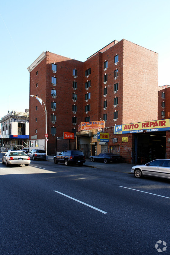
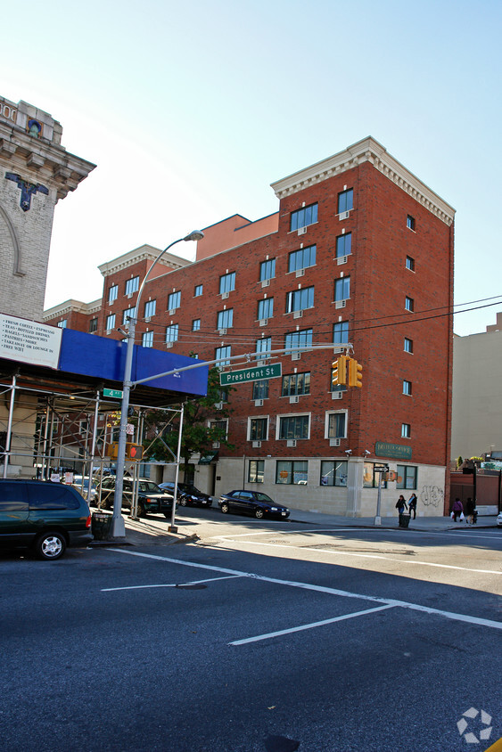

Find your new apartment at The Rigas. Located at 586 President St. in Brooklyn, this community is an ideal place to move. From availability to location, the professional leasing team is excited to help you find the perfect place. Make a visit to see the current floorplan options. It's time to love where you live. Stop by for a visit today.
The Rigas is an apartment community located in Kings County and the 11215 ZIP Code. This area is served by the New York City Special Schools - District 75 attendance zone.
Air Conditioning
Heating
Oven
Range
Park Slope is a Brooklyn neighborhood that has an easygoing vibe, giving it an almost suburban feel in the heart of the city. As a resident of Park Slope, you’ll see residents often walking their dogs and children throughout the quiet streets of the neighborhood.
Apartment rentals can be found in classic brick-buildings with beautiful views. Park Slope borders Prospect Park where residents enjoy massive open green space filled with historic homes, a popular zoo, a large lake, and recreation opportunities.
If you like living near late-night spots, you'll enjoy being near local favorites like Union Hall, a large bar, restaurant, and live music and comedy venue in the heart of Park Slope. Decorated as a fireside, stately library with a cozy atmosphere, Union Hall offers indoor bocce ball, outdoor garden seating, and a downstairs bar with live performances.
Learn more about living in Park SlopeCompare neighborhood and city base rent averages by bedroom.
| Park Slope | Brooklyn, NY | |
|---|---|---|
| Studio | $2,997 | $2,654 |
| 1 Bedroom | $3,073 | $2,974 |
| 2 Bedrooms | $3,796 | $3,908 |
| 3 Bedrooms | $4,022 | $4,831 |
| Colleges & Universities | Distance | ||
|---|---|---|---|
| Colleges & Universities | Distance | ||
| Drive: | 4 min | 1.4 mi | |
| Drive: | 5 min | 1.6 mi | |
| Drive: | 5 min | 1.6 mi | |
| Drive: | 6 min | 1.8 mi |


Transportation options available in Brooklyn include Union Street, located 0.1 mile from The Rigas. The Rigas is near LaGuardia, located 11.0 miles or 22 minutes away, and Newark Liberty International, located 15.7 miles or 28 minutes away.
| Transit / Subway | Distance | ||
|---|---|---|---|
| Transit / Subway | Distance | ||
|
|
Walk: | 1 min | 0.1 mi |
|
|
Walk: | 10 min | 0.5 mi |
|
|
Walk: | 12 min | 0.7 mi |
|
|
Walk: | 13 min | 0.7 mi |
|
|
Walk: | 14 min | 0.8 mi |
| Commuter Rail | Distance | ||
|---|---|---|---|
| Commuter Rail | Distance | ||
|
|
Walk: | 14 min | 0.7 mi |
|
|
Drive: | 7 min | 2.3 mi |
|
|
Drive: | 14 min | 4.7 mi |
|
|
Drive: | 14 min | 4.9 mi |
|
|
Drive: | 20 min | 7.5 mi |
| Airports | Distance | ||
|---|---|---|---|
| Airports | Distance | ||
|
LaGuardia
|
Drive: | 22 min | 11.0 mi |
|
Newark Liberty International
|
Drive: | 28 min | 15.7 mi |
Time and distance from The Rigas.
| Shopping Centers | Distance | ||
|---|---|---|---|
| Shopping Centers | Distance | ||
| Walk: | 17 min | 0.9 mi | |
| Drive: | 6 min | 2.0 mi |
| Parks and Recreation | Distance | ||
|---|---|---|---|
| Parks and Recreation | Distance | ||
|
Gowanus Canal
|
Walk: | 13 min | 0.7 mi |
|
Prospect Park
|
Drive: | 4 min | 1.4 mi |
|
Brooklyn Botanic Garden
|
Drive: | 4 min | 1.5 mi |
|
Fort Greene Park
|
Drive: | 5 min | 1.5 mi |
|
Cobble Hill Park
|
Drive: | 6 min | 1.5 mi |
| Hospitals | Distance | ||
|---|---|---|---|
| Hospitals | Distance | ||
| Drive: | 4 min | 1.3 mi | |
| Drive: | 5 min | 1.4 mi | |
| Drive: | 10 min | 3.0 mi |
| Military Bases | Distance | ||
|---|---|---|---|
| Military Bases | Distance | ||
| Drive: | 11 min | 5.2 mi | |
| Drive: | 13 min | 6.1 mi |

What Are Walk Score®, Transit Score®, and Bike Score® Ratings?
Walk Score® measures the walkability of any address. Transit Score® measures access to public transit. Bike Score® measures the bikeability of any address.
What is a Sound Score Rating?
A Sound Score Rating aggregates noise caused by vehicle traffic, airplane traffic and local sources

586 President St
Brooklyn, NY 11215


