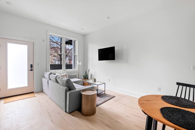
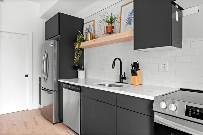
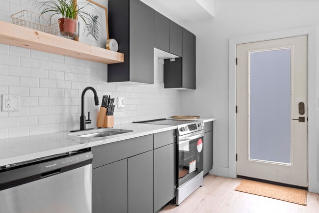
Located in Philadelphia's vibrant Fishtown neighborhood, this modern 1-bedroom, 1-bathroom unit offers a thoughtfully designed layout with clean, contemporary finishes throughout. Light-toned hardwood floors run continuously through the entire space, creating a warm and cohesive aesthetic. The open-concept kitchen and living area serves as the heart of the unit, featuring a striking kitchen island with a marble-veined quartz countertop, an integrated sink with a matte black faucet, and dark cabinetry that contrasts elegantly with the bright white walls. Stainless steel appliances, including a refrigerator, range, and microwave, complete the well-appointed kitchen. A large window in the living area floods the space with natural light and provides views of the surrounding neighborhood. The spacious bedroom includes double closets with clean panel doors, a ceiling fan, and a window offering additional natural light and city views. The bathroom is sleekly designed with a floating wood vanity, white quartz countertop, matte black fixtures, a glass-enclosed walk-in shower with white tile surround, and textured stone-style flooring. A dedicated utility room and hallway round out the practical layout of this well-designed urban residence.
-

-
Matterport 3D Exterior

-
The Firehouse Apartments
1221 N 4th St,
Philadelphia,
PA
19122
-
Monthly Rent
$1,500 - $2,750
-
Bedrooms
1 - 2 bd
-
Bathrooms
1 - 2 ba
-
Square Feet
547 - 950 sq ft
Live inside one of Philadelphia’s most unique apartment communities — a restored historic firehouse transformed into modern loft-style residences in the heart of Olde Kensington/Fishtown. The Firehouse Apartments combine historic Philadelphia architecture with modern finishes and spacious layouts designed for today’s city living. Featuring oversized windows, high ceilings, quartz countertops, in-unit washer & dryer, stainless steel appliances, and unique floor plans full of character, these apartments offer a living experience unlike anything else in the neighborhood. Residents enjoy convenient amenities including secure access, garage parking availability, bike storage, rooftop/common outdoor spaces, and a highly walkable location just minutes from Fishtown, Northern Liberties, Frankford Avenue, SEPTA transit, restaurants, coffee shops, nightlife, and local shopping. Located in one of Philadelphia’s fastest-growing neighborhoods, The Firehouse Apartments are perfect for professionals, creatives, and renters seeking authentic city living with historic charm and modern comfort. Schedule your tour today and experience one of Philadelphia’s most distinctive apartment communities.
Highlights
- Walker's Paradise
- Premier Transit Location
- Loft Layout
- Roof Terrace
- High Ceilings
- Planned Social Activities
- Walking/Biking Trails
- Views
- Patio
Pricing & Floor Plans
-
Unit 33price $1,500square feet 547availibility Now
-
Unit 21price $1,600square feet 547availibility Now
-
Unit 24price $1,700square feet 593availibility Now
-
Unit 33price $1,500square feet 547availibility Now
-
Unit 21price $1,600square feet 547availibility Now
-
Unit 24price $1,700square feet 593availibility Now
Fees and Policies
The fees listed below are community-provided and may exclude utilities or add-ons. All payments are made directly to the property and are non-refundable unless otherwise specified. Use the Cost Calculator to determine costs based on your needs.
-
Storage Unit
-
Storage FeeCharged per rentable item.$35 / mo
-
-
Bike Storage
-
Storage FeeCharged per rentable item.$0
-
Property Fee Disclaimer: Based on community-supplied data and independent market research. Subject to change without notice. May exclude fees for mandatory or optional services and usage-based utilities.
Details
Property Information
-
Built in 1941
-
29 units/3 stories
Matterport 3D Tours
About The Firehouse Apartments
Live inside one of Philadelphia’s most unique apartment communities — a restored historic firehouse transformed into modern loft-style residences in the heart of Olde Kensington/Fishtown. The Firehouse Apartments combine historic Philadelphia architecture with modern finishes and spacious layouts designed for today’s city living. Featuring oversized windows, high ceilings, quartz countertops, in-unit washer & dryer, stainless steel appliances, and unique floor plans full of character, these apartments offer a living experience unlike anything else in the neighborhood. Residents enjoy convenient amenities including secure access, garage parking availability, bike storage, rooftop/common outdoor spaces, and a highly walkable location just minutes from Fishtown, Northern Liberties, Frankford Avenue, SEPTA transit, restaurants, coffee shops, nightlife, and local shopping. Located in one of Philadelphia’s fastest-growing neighborhoods, The Firehouse Apartments are perfect for professionals, creatives, and renters seeking authentic city living with historic charm and modern comfort. Schedule your tour today and experience one of Philadelphia’s most distinctive apartment communities.
The Firehouse Apartments is an apartment community located in Philadelphia County and the 19122 ZIP Code. This area is served by the The School District of Philadelphia attendance zone.
Contact
Community Amenities
Roof Terrace
Key Fob Entry
24 Hour Access
Bicycle Storage
- Maintenance on site
- 24 Hour Access
- Planned Social Activities
- EV Charging
- Key Fob Entry
- Storage Space
- Vintage Building
- Walk-Up
- Bicycle Storage
- Walking/Biking Trails
- Roof Terrace
- Courtyard
Apartment Features
Washer/Dryer
Air Conditioning
Dishwasher
Loft Layout
- Washer/Dryer
- Air Conditioning
- Heating
- Ceiling Fans
- Tub/Shower
- Dishwasher
- Disposal
- Stainless Steel Appliances
- Kitchen
- Oven
- Refrigerator
- Freezer
- Quartz Countertops
- High Ceilings
- Views
- Skylights
- Loft Layout
- Double Pane Windows
- Patio
Philadelphia sits at the center of American history and still carries that weight with quiet confidence — it's the city where the Declaration of Independence was signed, and today those same streets anchor neighborhoods full of energy and purpose. As Pennsylvania's largest city and the sixth most populous in the country, Philly draws renters with a broad economy spanning healthcare, financial services, biotechnology, and information technology, plus a university presence that includes the University of Pennsylvania, Drexel, Temple, and several other institutions spread across the city.
Neighborhoods here range considerably in character. Old City offers cobblestone streets alongside contemporary gallery spaces, Fishtown pulses with creative industries and converted-warehouse architecture, Rittenhouse Square delivers manicured parks and polished streets, and Manayunk brings a hillside village feel within city limits.
Learn more about living in PhiladelphiaCompare neighborhood and city base rent averages by bedroom.
| Olde Kensington | Philadelphia, PA | |
|---|---|---|
| Studio | $1,383 | $1,437 |
| 1 Bedroom | $1,797 | $1,785 |
| 2 Bedrooms | $2,449 | $2,222 |
| 3 Bedrooms | $3,069 | $2,913 |
- Maintenance on site
- 24 Hour Access
- Planned Social Activities
- EV Charging
- Key Fob Entry
- Storage Space
- Vintage Building
- Walk-Up
- Roof Terrace
- Courtyard
- Bicycle Storage
- Walking/Biking Trails
- Washer/Dryer
- Air Conditioning
- Heating
- Ceiling Fans
- Tub/Shower
- Dishwasher
- Disposal
- Stainless Steel Appliances
- Kitchen
- Oven
- Refrigerator
- Freezer
- Quartz Countertops
- High Ceilings
- Views
- Skylights
- Loft Layout
- Double Pane Windows
- Patio
| Monday | 9am - 5pm |
|---|---|
| Tuesday | 9am - 5pm |
| Wednesday | 9am - 5pm |
| Thursday | 9am - 5pm |
| Friday | 9am - 5pm |
| Saturday | 9am - 5pm |
| Sunday | 9am - 5pm |
| Colleges & Universities | Distance | ||
|---|---|---|---|
| Colleges & Universities | Distance | ||
| Drive: | 4 min | 1.5 mi | |
| Drive: | 4 min | 2.0 mi | |
| Drive: | 6 min | 2.0 mi | |
| Drive: | 5 min | 2.1 mi |


View GreatSchools Rating Methodology
Data provided by GreatSchools.org © 2026. All rights reserved.
Transportation options available in Philadelphia include Girard Av & 4Th St, located 0.1 mile from The Firehouse Apartments. The Firehouse Apartments is near Philadelphia International, located 12.8 miles or 23 minutes away, and Trenton Mercer, located 32.0 miles or 48 minutes away.
| Transit / Subway | Distance | ||
|---|---|---|---|
| Transit / Subway | Distance | ||
| Walk: | 1 min | 0.1 mi | |
| Walk: | 2 min | 0.1 mi | |
| Walk: | 3 min | 0.2 mi | |
| Walk: | 4 min | 0.2 mi | |
| Walk: | 6 min | 0.3 mi |
| Commuter Rail | Distance | ||
|---|---|---|---|
| Commuter Rail | Distance | ||
|
|
Drive: | 4 min | 1.4 mi |
|
|
Drive: | 5 min | 1.9 mi |
|
|
Drive: | 6 min | 2.2 mi |
|
|
Drive: | 5 min | 2.5 mi |
|
|
Drive: | 6 min | 2.6 mi |
| Airports | Distance | ||
|---|---|---|---|
| Airports | Distance | ||
|
Philadelphia International
|
Drive: | 23 min | 12.8 mi |
|
Trenton Mercer
|
Drive: | 48 min | 32.0 mi |
Scores provided by
Traffic
BusyAirport
CalmBusinesses
BusyScores provided by
HowLoud What is a Sound Score Rating? A Sound Score Rating aggregates noise caused by vehicle traffic, airplane traffic and local sources. How It WorksTime and distance from The Firehouse Apartments.
| Shopping Centers | Distance | ||
|---|---|---|---|
| Shopping Centers | Distance | ||
| Walk: | 7 min | 0.4 mi | |
| Walk: | 8 min | 0.5 mi | |
| Walk: | 10 min | 0.5 mi |
| Parks and Recreation | Distance | ||
|---|---|---|---|
| Parks and Recreation | Distance | ||
|
Edgar Allan Poe Nat'l Historic Site
|
Walk: | 18 min | 1.0 mi |
|
Independence National Historical Park
|
Drive: | 3 min | 1.6 mi |
|
Great Egg Harbor River
|
Drive: | 4 min | 1.7 mi |
|
Lower Delaware National Wild and Scenic River
|
Drive: | 4 min | 1.7 mi |
|
Wagner Free Institute of Science
|
Drive: | 5 min | 1.9 mi |
| Hospitals | Distance | ||
|---|---|---|---|
| Hospitals | Distance | ||
| Drive: | 4 min | 1.9 mi | |
| Drive: | 5 min | 2.1 mi | |
| Drive: | 6 min | 2.3 mi |
| Military Bases | Distance | ||
|---|---|---|---|
| Military Bases | Distance | ||
| Drive: | 13 min | 7.1 mi | |
| Drive: | 40 min | 18.8 mi | |
| Drive: | 40 min | 20.8 mi |
The Firehouse Apartments Photos
-
The Firehouse Apartments
-
1BR, 1BA - 742SF
-
-
-
-
-
-
-
Models
-
1BR, 1BA - 547SF
-
1BR, 1BA - 742SF
-
Roofdeck
-
Mezzanine
Nearby Apartments
Within 50 Miles of The Firehouse Apartments
The Firehouse Apartments has units with in‑unit washers and dryers, making laundry day simple for residents.
Utilities are not included in rent. Residents should plan to set up and pay for all services separately.
Contact this property for parking details.
The Firehouse Apartments has one to two-bedrooms with rent ranges from $1,500/mo. to $2,750/mo.
The Firehouse Apartments does not allow pets, though service animals are always welcome in accordance with applicable laws.
A good rule of thumb is to spend no more than 30% of your gross income on rent. Based on the lowest available rent of $1,500 for a one-bedroom, you would need to earn about $60,000 per year to qualify. Want to double-check your budget? Calculate how much rent you can afford with our Rent Affordability Calculator.
The Firehouse Apartments is not currently offering any rent specials. Check back soon, as promotions change frequently.
Yes! The Firehouse Apartments offers 6 Matterport 3D Tours. Explore different floor plans and see unit level details, all without leaving home.

1221 N 4th St
Philadelphia, PA 19122
Property Manager Responded