
Seabridge at Glen Cove
1 Spyglass Pky,
Vallejo, CA 94591
$2,200 - $2,500
1-2 Beds
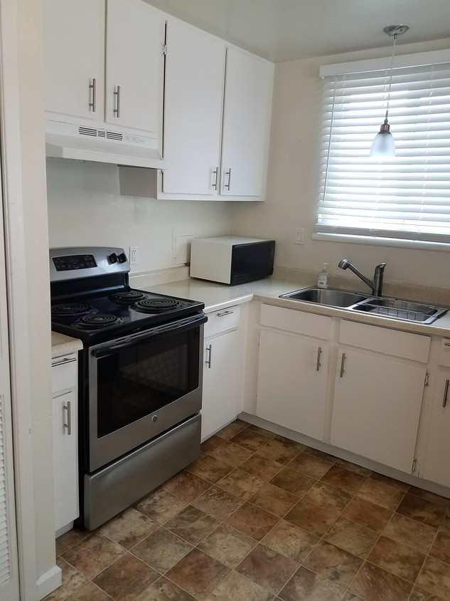
2 BDRM 1 BATH APARTMENT Springhill Apartments 673-695 Military East,1307-1323 East 7th Street, Benicia CA 94510 $1795 Rent 2 BDRM -1 BATH + Deposit FEATURES: Newly painted Laminate flooring living and bedrooms Upgraded appliances, refrigerator & stove Laundry facilities on site Professionally managed by E.E.N. Property Management, Inc. Non-smoking complex and no pets. Call Angelica at (707)416-1555 to set an appointment to view! $40 credit check fee per adult over 18 made out to EEN Property Management, Inc. At the time of applying we will require a valid identification or Driver's License, proof of gross income, minimum verifiable 2 X 1/2 monthly rent, credit check, and rental reference check. Availability and Styles subject to change without notice. Equal Housing Opportunity
Springhill Apartments is an apartment community located in Solano County and the 94510 ZIP Code. This area is served by the Benicia Unified School District attendance zone.
Air Conditioning
Granite Countertops
Refrigerator
Tile Floors
Benicia sits on the north bank of the Carquinez Strait, quietly holding onto a history that most California cities can only read about — it served as the state capital for thirteen months between 1853 and 1854, and the original Capitol building still stands downtown. That sense of history gives the city a grounded, unhurried character that sets it apart from busier Bay Area neighbors. Situated in Solano County, Benicia connects easily to Vallejo to the west and Martinez across the strait, while Interstate 680 and 780 put Sacramento, Oakland, and San Francisco within reasonable driving distance.
Daily life here moves at a pace that encourages actually noticing your surroundings. The downtown area anchors the city with waterfront views, local shops, and a working arts district that grew out of the converted Benicia Arsenal — once the largest weapons storehouse on the West Coast.
Learn more about living in Benicia| Colleges & Universities | Distance | ||
|---|---|---|---|
| Colleges & Universities | Distance | ||
| Drive: | 14 min | 9.1 mi | |
| Drive: | 20 min | 11.6 mi | |
| Drive: | 22 min | 15.8 mi | |
| Drive: | 24 min | 17.9 mi |


Transportation options available in Benicia include North Concord / Martinez, located 10.2 miles from Springhill Apartments. Springhill Apartments is near Metro Oakland International, located 36.5 miles or 48 minutes away, and San Francisco International, located 47.7 miles or 64 minutes away.
| Transit / Subway | Distance | ||
|---|---|---|---|
| Transit / Subway | Distance | ||
|
|
Drive: | 15 min | 10.2 mi |
|
|
Drive: | 16 min | 10.7 mi |
|
|
Drive: | 16 min | 12.0 mi |
| Commuter Rail | Distance | ||
|---|---|---|---|
| Commuter Rail | Distance | ||
|
|
Drive: | 8 min | 5.1 mi |
|
|
Drive: | 25 min | 19.8 mi |
| Drive: | 28 min | 21.5 mi | |
|
|
Drive: | 31 min | 25.2 mi |
| Drive: | 35 min | 27.5 mi |
| Airports | Distance | ||
|---|---|---|---|
| Airports | Distance | ||
|
Metro Oakland International
|
Drive: | 48 min | 36.5 mi |
|
San Francisco International
|
Drive: | 64 min | 47.7 mi |
Scores provided by
Traffic
-Airport
-Businesses
-Scores provided by
HowLoud What is a Sound Score Rating? A Sound Score Rating aggregates noise caused by vehicle traffic, airplane traffic and local sources. How It WorksTime and distance from Springhill Apartments.
| Shopping Centers | Distance | ||
|---|---|---|---|
| Shopping Centers | Distance | ||
| Walk: | 8 min | 0.4 mi | |
| Walk: | 13 min | 0.7 mi | |
| Walk: | 15 min | 0.8 mi |
| Parks and Recreation | Distance | ||
|---|---|---|---|
| Parks and Recreation | Distance | ||
|
Benicia Capitol State Historic Park
|
Walk: | 20 min | 1.1 mi |
|
Waterbird Regional Preserve
|
Drive: | 6 min | 4.1 mi |
|
Martinez Regional Shoreline
|
Drive: | 10 min | 4.5 mi |
|
Alhambra Creek Watershed
|
Drive: | 8 min | 5.1 mi |
|
Carquinez Strait Regional Shoreline
|
Drive: | 19 min | 12.0 mi |
| Hospitals | Distance | ||
|---|---|---|---|
| Hospitals | Distance | ||
| Drive: | 10 min | 5.8 mi | |
| Drive: | 12 min | 8.6 mi | |
| Drive: | 14 min | 9.7 mi |
| Military Bases | Distance | ||
|---|---|---|---|
| Military Bases | Distance | ||
| Drive: | 2 min | 1.1 mi | |
| Drive: | 18 min | 11.0 mi | |
| Drive: | 30 min | 12.9 mi |
Pets Allowed Fitness Center In Unit Washer & Dryer Stainless Steel Appliances Business Center Package Service Elevator
What Are Walk Score®, Transit Score®, and Bike Score® Ratings?
Walk Score® measures the walkability of any address. Transit Score® measures access to public transit. Bike Score® measures the bikeability of any address.
What is a Sound Score Rating?
A Sound Score Rating aggregates noise caused by vehicle traffic, airplane traffic and local sources.

673-695 Military E
Benicia, CA 94510


