
Arazo
12635 SW 172nd Ter,
Beaverton, OR 97007
$1,476 - $3,182
Studio - 3 Beds
Bedrooms
1 bd
Bathrooms
1 ba
Square Feet
536 sq ft
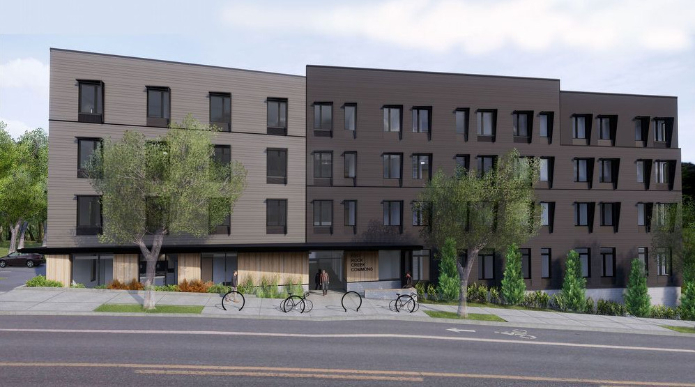
Red Rock Creek Commons is an income restricted property that features 1 bedroom apartment homes near SW Pacific Hwy/99W, with convenient access to high-frequency transit, grocery stores, PCC and potential employers. The apartment community will serve individuals and small households – in four stories with an elevator, a community room for services and activities, and access to the natural area around Red Rock Creek.
Red Rock Creek Commons is an income restricted property that features 1 bedroom apartment homes near SW Pacific Hwy/99W, with convenient access to high-frequency transit, grocery stores, PCC and potential employers. The apartment community will serve individuals and small households – in four stories with an elevator, a community room for services and activities, and access to the natural area around Red Rock Creek.
Red Rock Commons is an apartment community located in Washington County and the 97223 ZIP Code. This area is served by the Tigard-Tualatin School District 23j attendance zone.
Laundry Facilities
Elevator
Controlled Access
Recycling
Air Conditioning
Dishwasher
Hardwood Floors
Microwave
Refrigerator
Tub/Shower
Freezer
Ceiling Fans
The Tigard Triangle is a large neighborhood on the northeast side of downtown. It is situated between I-5 and the Beaverton Tigard Highway, with the Pacific Highway forming the northern edge of the triangle. The area, which was in limbo of sorts until recently, has become a popular, mixed-use neighborhood that is becoming increasingly walkable and bicycle-friendly. With its wide sidewalks, bike lanes, hilltop vistas, and wooded areas, the Tigard Triangle is quickly becoming Tigard's favorite neighborhood.
Covering roughly 425 acres and bordered by three major highways, the Tigard Triangle is as convenient as it is attractive. This live-work-play community contains a variety of office buildings, luxury apartment communities, charming neighborhoods, and convenient shopping areas. Residents also enjoy public art, benches, and small pocket parks, making the Tigard Triangle as family-friendly as it is trendy.
Learn more about living in Tigard TriangleCompare neighborhood and city base rent averages by bedroom.
| Tigard Triangle | Tigard, OR | |
|---|---|---|
| Studio | $1,498 | $1,467 |
| 1 Bedroom | $1,704 | $1,535 |
| 2 Bedrooms | $1,952 | $1,776 |
| 3 Bedrooms | $2,933 | $2,148 |
| Colleges & Universities | Distance | ||
|---|---|---|---|
| Colleges & Universities | Distance | ||
| Drive: | 5 min | 1.8 mi | |
| Drive: | 10 min | 5.7 mi | |
| Drive: | 13 min | 7.0 mi | |
| Drive: | 13 min | 7.0 mi |


Transportation options available in Tigard include Beaverton Transit Center (Blue, Red Lines), located 5.9 miles from Red Rock Commons. Red Rock Commons is near Portland International, located 19.5 miles or 30 minutes away.
| Transit / Subway | Distance | ||
|---|---|---|---|
| Transit / Subway | Distance | ||
|
|
Drive: | 11 min | 5.9 mi |
|
|
Drive: | 11 min | 6.0 mi |
|
|
Drive: | 13 min | 7.8 mi |
| Drive: | 19 min | 8.8 mi | |
|
|
Drive: | 16 min | 9.9 mi |
| Commuter Rail | Distance | ||
|---|---|---|---|
| Commuter Rail | Distance | ||
|
|
Drive: | 6 min | 2.1 mi |
|
|
Drive: | 6 min | 3.3 mi |
|
|
Drive: | 8 min | 4.8 mi |
|
|
Drive: | 10 min | 5.8 mi |
|
|
Drive: | 16 min | 9.3 mi |
| Airports | Distance | ||
|---|---|---|---|
| Airports | Distance | ||
|
Portland International
|
Drive: | 30 min | 19.5 mi |
Scores provided by
Traffic
-Airport
-Businesses
-Scores provided by
HowLoud What is a Sound Score Rating? A Sound Score Rating aggregates noise caused by vehicle traffic, airplane traffic and local sources. How It WorksTime and distance from Red Rock Commons.
| Shopping Centers | Distance | ||
|---|---|---|---|
| Shopping Centers | Distance | ||
| Walk: | 9 min | 0.5 mi | |
| Walk: | 11 min | 0.6 mi | |
| Walk: | 12 min | 0.6 mi |
| Parks and Recreation | Distance | ||
|---|---|---|---|
| Parks and Recreation | Distance | ||
|
Lesser Park
|
Walk: | 14 min | 0.8 mi |
|
West Portland Park Natural Area
|
Drive: | 4 min | 1.7 mi |
|
Woods Memorial Natural Area
|
Drive: | 6 min | 2.5 mi |
|
Maricara Natural Area
|
Drive: | 6 min | 2.8 mi |
|
April Hill Park
|
Drive: | 11 min | 4.1 mi |
| Hospitals | Distance | ||
|---|---|---|---|
| Hospitals | Distance | ||
| Drive: | 8 min | 5.0 mi | |
| Drive: | 11 min | 7.2 mi | |
| Drive: | 14 min | 7.3 mi |
| Military Bases | Distance | ||
|---|---|---|---|
| Military Bases | Distance | ||
| Drive: | 28 min | 15.2 mi | |
| Drive: | 53 min | 32.5 mi |
Pets Allowed Fitness Center Dishwasher Refrigerator Kitchen In Unit Washer & Dryer
Pets Allowed Fitness Center In Unit Washer & Dryer Walk-In Closets Elevator Rooftop Deck
Pets Allowed Fitness Center Pool Dishwasher Refrigerator Kitchen
What Are Walk Score®, Transit Score®, and Bike Score® Ratings?
Walk Score® measures the walkability of any address. Transit Score® measures access to public transit. Bike Score® measures the bikeability of any address.
What is a Sound Score Rating?
A Sound Score Rating aggregates noise caused by vehicle traffic, airplane traffic and local sources.

11090 SW 68th Pky
Tigard, OR 97223


