
Olde Derby Village
4 Olde Derby Rd,
Norwood, MA 02062
$2,100 - $3,200 Total Monthly Price
1-3 Beds 12 Month Lease

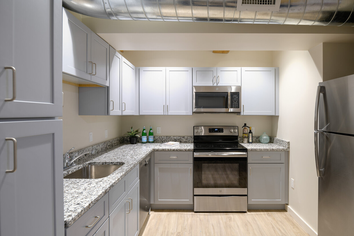
Newly renovated historical building located in central Norwood! Steps away from the T and with parking available. Each unit features stainless steel appliances, granite countertops, high ceilings and central air.
Print Lofts is an apartment community located in Norfolk County and the 02062 ZIP Code. This area is served by the Norwood School District attendance zone.
Fitness Center
Laundry Facilities
Elevator
Public Transportation
Air Conditioning
Dishwasher
High Speed Internet Access
Granite Countertops
Norwood sits along the Neponset River about 15 miles southwest of Boston, offering a genuine small-town feel without straying far from the city’s energy. The downtown area near Washington and Nahatan Streets anchors daily life with a town common, local cafes, specialty shops, and a grocery store all within easy walking distance. Cutler Park and several other green spaces give residents room to unwind, and multiple MBTA commuter rail stations make getting into Boston straightforward. Officially incorporated in 1872 after separating from Dedham, Norwood carries a long history that still shapes its close-knit character.
The rental market offers solid variety, from cozy studio apartments and one-bedroom units in smaller buildings to spacious multi-bedroom apartment communities. Townhomes and garden-style rentals add even more options for those wanting extra room.
Learn more about living in Norwood| Colleges & Universities | Distance | ||
|---|---|---|---|
| Colleges & Universities | Distance | ||
| Drive: | 16 min | 7.1 mi | |
| Drive: | 16 min | 7.7 mi | |
| Drive: | 20 min | 9.5 mi | |
| Drive: | 26 min | 11.8 mi |


Transportation options available in Norwood include Mattapan Station, located 9.7 miles from Print Lofts. Print Lofts is near General Edward Lawrence Logan International, located 18.8 miles or 36 minutes away, and Rhode Island Tf Green International, located 39.0 miles or 57 minutes away.
| Transit / Subway | Distance | ||
|---|---|---|---|
| Transit / Subway | Distance | ||
|
|
Drive: | 19 min | 9.7 mi |
|
|
Drive: | 20 min | 10.2 mi |
|
|
Drive: | 20 min | 10.3 mi |
|
|
Drive: | 21 min | 10.8 mi |
|
|
Drive: | 23 min | 11.4 mi |
| Commuter Rail | Distance | ||
|---|---|---|---|
| Commuter Rail | Distance | ||
|
|
Walk: | 4 min | 0.2 mi |
|
|
Walk: | 14 min | 0.7 mi |
|
|
Drive: | 5 min | 2.2 mi |
|
|
Drive: | 6 min | 2.8 mi |
|
|
Drive: | 8 min | 4.5 mi |
| Airports | Distance | ||
|---|---|---|---|
| Airports | Distance | ||
|
General Edward Lawrence Logan International
|
Drive: | 36 min | 18.8 mi |
|
Rhode Island Tf Green International
|
Drive: | 57 min | 39.0 mi |
Scores provided by
Traffic
BusyAirport
ActiveBusinesses
ActiveScores provided by
HowLoud What is a Sound Score Rating? A Sound Score Rating aggregates noise caused by vehicle traffic, airplane traffic and local sources. How It WorksTime and distance from Print Lofts.
| Shopping Centers | Distance | ||
|---|---|---|---|
| Shopping Centers | Distance | ||
| Walk: | 6 min | 0.3 mi | |
| Walk: | 6 min | 0.3 mi | |
| Walk: | 6 min | 0.3 mi |
| Parks and Recreation | Distance | ||
|---|---|---|---|
| Parks and Recreation | Distance | ||
|
Mass Audubon's Mildred Morse Allen Wildlife Sanctuary
|
Drive: | 11 min | 5.2 mi |
|
Museum of American Bird Art at Mass Audubon
|
Drive: | 11 min | 5.2 mi |
|
Mass Audubon's Moose Hill Wildlife Sanctuary
|
Drive: | 12 min | 5.7 mi |
|
Mass Audubon's Blue Hills Trailside Museum
|
Drive: | 13 min | 7.7 mi |
|
Blue Hills Reservation
|
Drive: | 15 min | 8.7 mi |
| Hospitals | Distance | ||
|---|---|---|---|
| Hospitals | Distance | ||
| Walk: | 7 min | 0.4 mi | |
| Drive: | 5 min | 2.2 mi | |
| Drive: | 15 min | 7.4 mi |
| Military Bases | Distance | ||
|---|---|---|---|
| Military Bases | Distance | ||
| Drive: | 29 min | 14.5 mi | |
| Drive: | 37 min | 23.0 mi | |
| Drive: | 61 min | 35.1 mi |
Pets Allowed Fitness Center In Unit Washer & Dryer Balcony Elevator Rooftop Deck
Pets Allowed Maintenance on site Heat Controlled Access Elevator Laundry Facilities
Pets Allowed Fitness Center Dishwasher Refrigerator Kitchen In Unit Washer & Dryer
Pets Allowed Fitness Center Pool Dishwasher Kitchen In Unit Washer & Dryer Walk-In Closets
Pets Allowed Fitness Center Pool Dishwasher Kitchen In Unit Washer & Dryer
Pets Allowed Fitness Center Dishwasher Refrigerator Kitchen In Unit Washer & Dryer
129 Guild St
Norwood, MA 02062


