
Aerie at Wardman Park
2650 Woodley Rd NW,
Washington, DC 20008
$3,932 - $9,047 Total Monthly Price
1-3 Beds

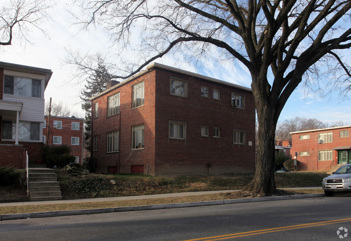
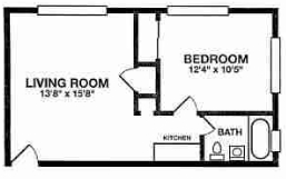
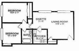
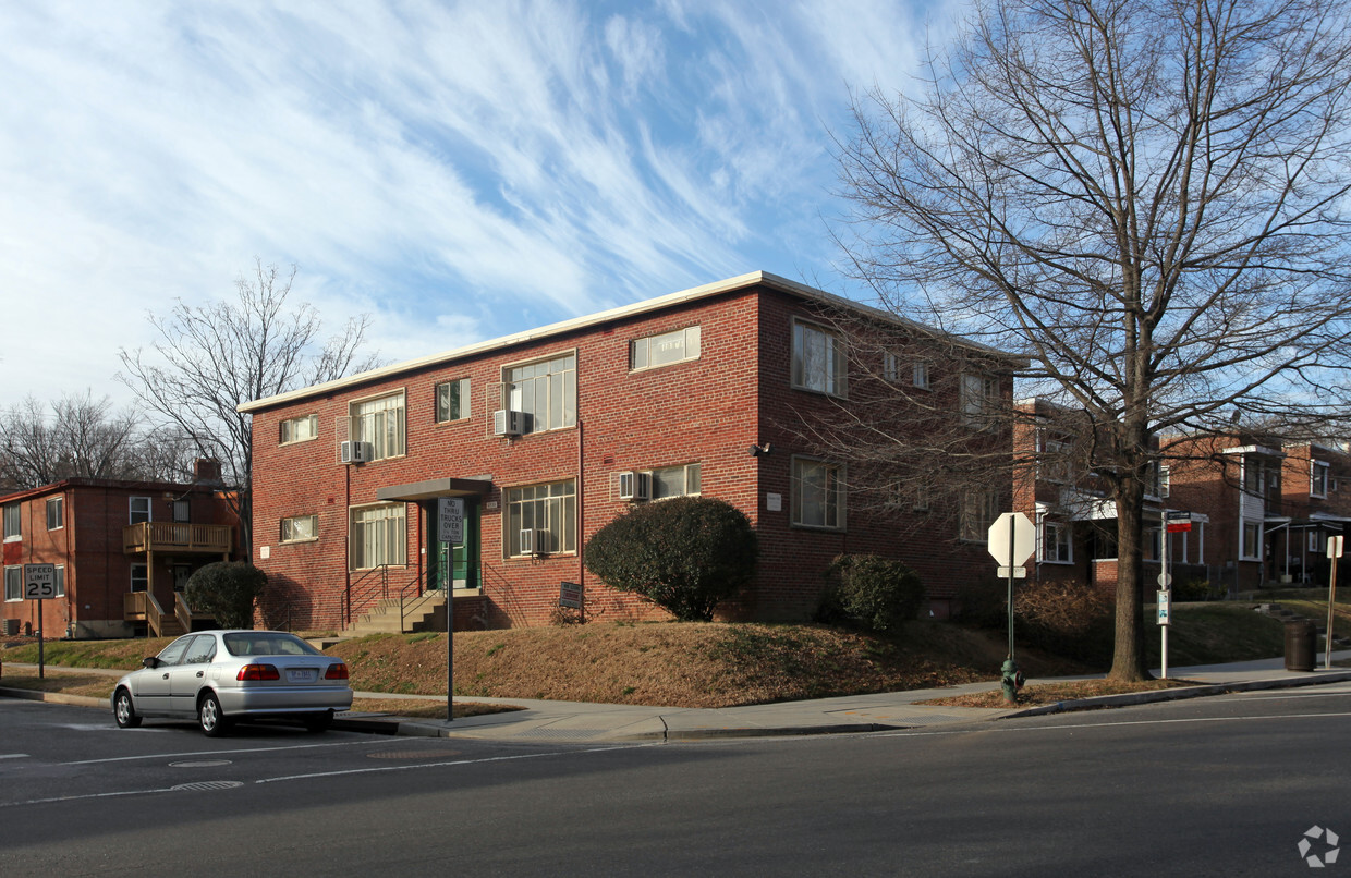
Pleasant Hills offers perfectly situated Northeast DC apartments. Live conveniently between Fort Totten and Brookland, next to the Brookland/CUA Metro station and Catholic University. Lawns and trees surround our bright and spacious, one- and two-bedroom, garden-style corner apartments. At Pleasant Hills, you’ll be just a short distance from Providence Hospital and the Washington Hospital Center, and have easy access to Downtown Silver Spring, Capitol Hill and all of downtown DC’s retail and dining. Come to Pleasant Hills and experience affordable living in DC at its best.
Pleasant Hills Apartments is an apartment community located in District of Columbia County and the 20011 ZIP Code. This area is served by the District Of Columbia Public Schools attendance zone.
Unique Features
High Speed Internet Access
Hardwood Floors
Refrigerator
Security System
Pleasant Hill begins along Allison Street between Rock Creek Cemetery and Fort Totten Park. It extends south to Scale Gate Road, on the west side of the Catholic University of America. This small neighborhood also borders the Armed Forces Retirement Home-Washington, a National Historic District that includes President Lincoln's Cottage. Hawaii Avenue runs through the neighborhood and offers several bus stops. The neighborhood is hilly and wooded, featuring brick apartment buildings and townhomes along shady streets.
Learn more about living in Pleasant HillCompare neighborhood and city base rent averages by bedroom.
| Pleasant Hill | Washington, DC | |
|---|---|---|
| Studio | - | $1,833 |
| 1 Bedroom | $1,338 | $2,269 |
| 2 Bedrooms | $1,856 | $3,118 |
| 3 Bedrooms | - | $3,948 |
| Colleges & Universities | Distance | ||
|---|---|---|---|
| Colleges & Universities | Distance | ||
| Walk: | 16 min | 0.8 mi | |
| Drive: | 4 min | 1.5 mi | |
| Drive: | 6 min | 2.7 mi | |
| Drive: | 8 min | 3.4 mi |

Transportation options available in Washington include Fort Totten, located 1.4 miles from Pleasant Hills Apartments. Pleasant Hills Apartments is near Ronald Reagan Washington Ntl, located 9.2 miles or 17 minutes away, and Baltimore/Washington International Thurgood Marshall, located 32.1 miles or 44 minutes away.
| Transit / Subway | Distance | ||
|---|---|---|---|
| Transit / Subway | Distance | ||
|
|
Drive: | 3 min | 1.4 mi |
|
|
Drive: | 3 min | 1.5 mi |
|
|
Drive: | 3 min | 1.5 mi |
|
|
Drive: | 6 min | 2.3 mi |
|
|
Drive: | 5 min | 2.5 mi |
| Commuter Rail | Distance | ||
|---|---|---|---|
| Commuter Rail | Distance | ||
|
|
Drive: | 7 min | 3.8 mi |
|
|
Drive: | 8 min | 3.9 mi |
| Drive: | 8 min | 4.3 mi | |
| Drive: | 9 min | 4.6 mi | |
|
|
Drive: | 9 min | 5.0 mi |
| Airports | Distance | ||
|---|---|---|---|
| Airports | Distance | ||
|
Ronald Reagan Washington Ntl
|
Drive: | 17 min | 9.2 mi |
|
Baltimore/Washington International Thurgood Marshall
|
Drive: | 44 min | 32.1 mi |
Scores provided by
Traffic
-Airport
-Businesses
-Scores provided by
HowLoud What is a Sound Score Rating? A Sound Score Rating aggregates noise caused by vehicle traffic, airplane traffic and local sources. How It WorksTime and distance from Pleasant Hills Apartments.
| Shopping Centers | Distance | ||
|---|---|---|---|
| Shopping Centers | Distance | ||
| Walk: | 5 min | 0.3 mi | |
| Walk: | 17 min | 0.9 mi | |
| Drive: | 3 min | 1.6 mi |
| Parks and Recreation | Distance | ||
|---|---|---|---|
| Parks and Recreation | Distance | ||
|
Mount Rainier Nature Center
|
Drive: | 5 min | 2.5 mi |
|
Meridian Hill Park
|
Drive: | 6 min | 3.1 mi |
|
Carter G. Woodson Home National Historic Site
|
Drive: | 6 min | 3.3 mi |
|
Washington Youth Garden
|
Drive: | 7 min | 4.0 mi |
|
Rock Creek Park
|
Drive: | 9 min | 4.0 mi |
| Hospitals | Distance | ||
|---|---|---|---|
| Hospitals | Distance | ||
| Drive: | 4 min | 1.7 mi | |
| Drive: | 4 min | 1.9 mi | |
| Drive: | 6 min | 3.2 mi |
| Military Bases | Distance | ||
|---|---|---|---|
| Military Bases | Distance | ||
| Drive: | 2 min | 1.1 mi | |
| Drive: | 14 min | 5.7 mi | |
| Drive: | 12 min | 6.1 mi |
Pets Allowed Fitness Center Pool Dishwasher In Unit Washer & Dryer Business Center Package Service

Pets Allowed Fitness Center In Unit Washer & Dryer Balcony Courtyard Concierge EV Charging
What Are Walk Score®, Transit Score®, and Bike Score® Ratings?
Walk Score® measures the walkability of any address. Transit Score® measures access to public transit. Bike Score® measures the bikeability of any address.
What is a Sound Score Rating?
A Sound Score Rating aggregates noise caused by vehicle traffic, airplane traffic and local sources.
4510 2nd St NE
Washington, DC 20011


