
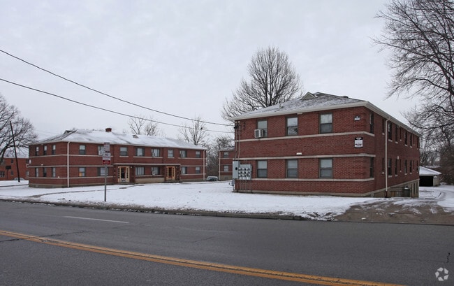
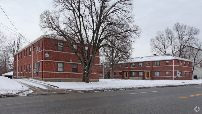
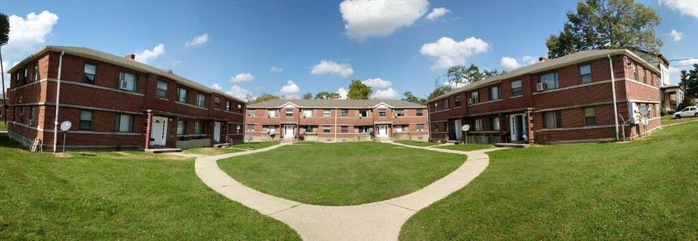
Mt Airy Horseshoe Apartments
2712-2722 W North Bend Rd,
Cincinnati,
OH
45239
-
Monthly Rent
$875 - $975
-
Bedrooms
1 - 2 bd
-
Bathrooms
1 ba
-
Square Feet
850 - 950 sq ft

Very large apartments with plenty of closet space! Great opportunity to live right in the heart of Mt Airy, near the famous water tower. Owner pays gas, heat, water, sewer, and trash. Tenant only pays the light bill.
Highlights
- English and Spanish Speaking Staff
- Hardwood Floors
Pricing & Floor Plans
-
Unit 1Bedprice $875square feet 850availibility Now
-
Unit 2Bedprice $975square feet 950availibility Now
-
Unit 1Bedprice $875square feet 850availibility Now
-
Unit 2Bedprice $975square feet 950availibility Now
Fees and Policies
The fees listed below are community-provided and may exclude utilities or add-ons. All payments are made directly to the property and are non-refundable unless otherwise specified.
Pet policies are negotiable.
-
Garage Lot
-
Parking FeeMax of 25. Charged per vehicle.$0 / mo
CommentsMax of 25, Free parking in back. Plenty of spaces including garage spaces at no extra charge.Read More Read Less -
Property Fee Disclaimer: Based on community-supplied data and independent market research. Subject to change without notice. May exclude fees for mandatory or optional services and usage-based utilities.
Details
Utilities Included
-
Gas
-
Water
-
Heat
-
Trash Removal
-
Sewer
Property Information
-
Built in 1951
-
21 units/2 stories
About Mt Airy Horseshoe Apartments
Very large apartments with plenty of closet space! Great opportunity to live right in the heart of Mt Airy, near the famous water tower. Owner pays gas, heat, water, sewer, and trash. Tenant only pays the light bill.
Mt Airy Horseshoe Apartments is an apartment community located in Hamilton County and the 45239 ZIP Code. This area is served by the Cincinnati Public Schools attendance zone.
Contact
Community Amenities
- Laundry Facilities
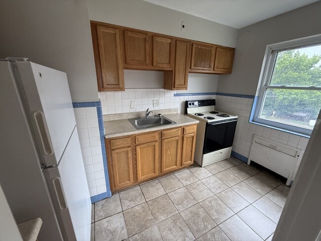
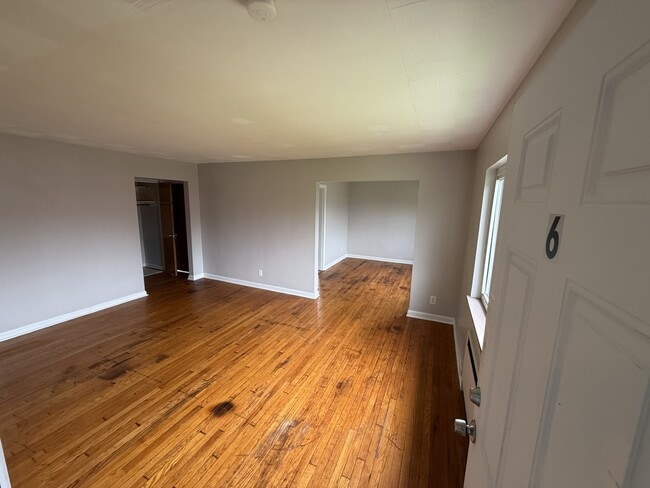
Apartment Features
Air Conditioning
Hardwood Floors
Refrigerator
Tub/Shower
- Air Conditioning
- Heating
- Tub/Shower
- Handrails
- Pantry
- Kitchen
- Oven
- Range
- Refrigerator
- Freezer
- Hardwood Floors
- Carpet
- Tile Floors
- Vinyl Flooring
Mount Airy is a classic suburban neighborhood with peaceful streets lined with single-family homes. Interstate 74 and Highway 22 makes the seven mile drive into Downtown Cincinnati and beyond accessible, but Mount Airy has a lot to offer from within. Its southern border encompasses Mount Airy Forest, which provides residents with outdoor fun. There are also a few fast food restaurants within the neighborhood, but residents can easily travel to the surrounding areas or into downtown for a diverse selection of restaurants. Renters will find that they have a few affordable options of apartments in longstanding brick buildings to choose from.
Learn more about living in Mount AiryCompare neighborhood and city base rent averages by bedroom.
| Mount Airy | Cincinnati, OH | |
|---|---|---|
| Studio | - | $1,064 |
| 1 Bedroom | $847 | $1,141 |
| 2 Bedrooms | $1,012 | $1,434 |
| 3 Bedrooms | $1,388 | $1,753 |
- Laundry Facilities
- Air Conditioning
- Heating
- Tub/Shower
- Handrails
- Pantry
- Kitchen
- Oven
- Range
- Refrigerator
- Freezer
- Hardwood Floors
- Carpet
- Tile Floors
- Vinyl Flooring
| Monday | By Appointment |
|---|---|
| Tuesday | By Appointment |
| Wednesday | By Appointment |
| Thursday | By Appointment |
| Friday | By Appointment |
| Saturday | By Appointment |
| Sunday | By Appointment |
| Colleges & Universities | Distance | ||
|---|---|---|---|
| Colleges & Universities | Distance | ||
| Drive: | 12 min | 4.7 mi | |
| Drive: | 13 min | 6.3 mi | |
| Drive: | 15 min | 6.7 mi | |
| Drive: | 18 min | 8.3 mi |


View GreatSchools Rating Methodology
Data provided by GreatSchools.org © 2026. All rights reserved.
Transportation options available in Cincinnati include Brewery District Station - Elm & Henry, located 7.0 miles from Mt Airy Horseshoe Apartments. Mt Airy Horseshoe Apartments is near Cincinnati/Northern Kentucky International, located 21.0 miles or 38 minutes away.
| Transit / Subway | Distance | ||
|---|---|---|---|
| Transit / Subway | Distance | ||
| Drive: | 14 min | 7.0 mi | |
| Drive: | 14 min | 7.1 mi | |
| Drive: | 15 min | 7.2 mi | |
| Drive: | 15 min | 7.2 mi | |
| Drive: | 15 min | 7.3 mi |
| Commuter Rail | Distance | ||
|---|---|---|---|
| Commuter Rail | Distance | ||
|
|
Drive: | 14 min | 7.0 mi |
| Airports | Distance | ||
|---|---|---|---|
| Airports | Distance | ||
|
Cincinnati/Northern Kentucky International
|
Drive: | 38 min | 21.0 mi |
Scores provided by
Traffic
ActiveAirport
CalmBusinesses
CalmScores provided by
HowLoud What is a Sound Score Rating? A Sound Score Rating aggregates noise caused by vehicle traffic, airplane traffic and local sources. How It WorksTime and distance from Mt Airy Horseshoe Apartments.
| Shopping Centers | Distance | ||
|---|---|---|---|
| Shopping Centers | Distance | ||
| Drive: | 4 min | 1.4 mi | |
| Drive: | 3 min | 1.4 mi | |
| Drive: | 3 min | 1.4 mi |
| Parks and Recreation | Distance | ||
|---|---|---|---|
| Parks and Recreation | Distance | ||
|
Mt. Airy Forest
|
Drive: | 5 min | 2.0 mi |
|
LaBoiteaux Woods
|
Drive: | 6 min | 2.6 mi |
|
Buttercup Valley
|
Drive: | 7 min | 3.0 mi |
|
Farbach-Werner Nature Preserve
|
Drive: | 9 min | 3.7 mi |
|
Caldwell Preserve
|
Drive: | 12 min | 5.4 mi |
| Hospitals | Distance | ||
|---|---|---|---|
| Hospitals | Distance | ||
| Drive: | 6 min | 2.6 mi | |
| Drive: | 12 min | 5.6 mi | |
| Drive: | 15 min | 6.8 mi |
| Military Bases | Distance | ||
|---|---|---|---|
| Military Bases | Distance | ||
| Drive: | 72 min | 52.8 mi | |
| Drive: | 78 min | 57.8 mi | |
| Drive: | 80 min | 61.1 mi |
Mt Airy Horseshoe Apartments Photos
-
Mt Airy Horseshoe Apartments
-
Primary Photo
-
-
-
-
-
-
-
Nearby Apartments
Within 50 Miles of Mt Airy Horseshoe Apartments
-
Westwood Northern Quad Apartments
2580 Westwood Northern Blvd
Cincinnati, OH 45211
$875 - $975
1-2 Br 2.8 mi
-
West Galbraith Apartments
1209 W Galbraith Rd
Cincinnati, OH 45231
$850
1 Br 2.9 mi
-
Clinton Springs Quad Apartments
122 Clinton Springs Ave
Cincinnati, OH 45217
$875
1 Br 4.5 mi
-
Straight Street Apartments
650 Straight St
Cincinnati, OH 45219
$850 - $950
1-2 Br 4.8 mi
-
Crest Hill Quad Apartments
1582 Crest Hill Ave
Cincinnati, OH 45237
$975
2 Br 6.2 mi
-
Anna Marie Apartments, LLC
300-400 Hillside Ave
Cincinnati, OH 45215
$875 - $975
1-2 Br 7.0 mi
While Mt Airy Horseshoe Apartments does not provide in‑unit laundry, on‑site laundry facilities are available for shared resident use.
Select utilities are included in rent at Mt Airy Horseshoe Apartments, including gas, water, heat, trash removal, and sewer. Residents are responsible for any other utilities not listed.
Parking is available at Mt Airy Horseshoe Apartments and is free of charge for residents.
Mt Airy Horseshoe Apartments has one to two-bedrooms with rent ranges from $875/mo. to $975/mo.
Mt Airy Horseshoe Apartments does not allow pets, though service animals are always welcome in accordance with applicable laws.
A good rule of thumb is to spend no more than 30% of your gross income on rent. Based on the lowest available rent of $875 for a one-bedroom, you would need to earn about $35,000 per year to qualify. Want to double-check your budget? Calculate how much rent you can afford with our Rent Affordability Calculator.
Mt Airy Horseshoe Apartments is not currently offering any rent specials. Check back soon, as promotions change frequently.
While Mt Airy Horseshoe Apartments does not offer Matterport 3D tours, renters can request a tour directly through our online platform.
What Are Walk Score®, Transit Score®, and Bike Score® Ratings?
Walk Score® measures the walkability of any address. Transit Score® measures access to public transit. Bike Score® measures the bikeability of any address.
What is a Sound Score Rating?
A Sound Score Rating aggregates noise caused by vehicle traffic, airplane traffic and local sources.
2712-2722 W North Bend Rd
Cincinnati, OH 45239