Background Image

Del Rey Oaks, CA Area Guide

A centrally located suburb off the coast of Monterey Bay

Bay Upscale Coastal

Del Rey Oaks offers something rare on the Monterey Peninsula: the calm of a small, tree-lined residential enclave with outsized access to coastal California's best destinations. Spanning just one square mile, this quiet city borders Seaside to the northwest and Monterey to the west, putting beaches, college campuses, and dining corridors minutes away. Daily life here revolves around walkable neighborhood streets, the adjacent Laguna Grande Regional Park, and the broader Peninsula amenities that residents treat as their own backyard.

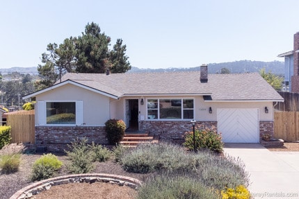
Rentals in Del Rey Oaks skew heavily toward single-family rental homes, reflecting the city's residential character, though proximity to Monterey and Seaside means nearby apartment communities and townhome communities are within easy reach along shared corridors. Architecture throughout leans toward mid-century California ranch and cottage styles set among mature oaks.

The city incorporated on September 3, 1953, under its current name -- a Spanish phrase meaning "Of the King" -- having previously gone by Del Rey Woods. The Naval Postgraduate School operates just 2.74 miles away, and Cal State Monterey Bay sits about seven miles out, giving the broader area a steady institutional and educational presence.

Demographics

Median Household Income

$116,054

Average: $148,319

Education

556

Residents Have a Degree

Job Market

817

Workers Employed

Age Distribution
Get a sense of this area's population profile.

Median Age

50 Years

Largest Age Group

60-69 Years

Approximately 15% of Residents

Under 20

17%

Over 65

28%

Housing Distribution

Del Rey Oaks has more homeowners than renters.

Renters
29%
Non-Renters
71%

Education Distribution

Review this city's overall education levels.

Bachelor's or Higher
30%
Other Education
70%

Learn More About Del Rey Oaks

Getting Around

Exceptionally Drivable

Drivability

100 / 100

Somewhat Bikeable

Bikeability

20 / 100

Points of Interest

Parks and Recreation

  • Monterey State Beach
  • Monterey County Youth Museum
  • Monterey State Historic Park
  • Monterey Maritime Museum
  • Jack's Peak County Park

Airports

  • Monterey Regional

Top Apartments in Del Rey Oaks

Houses for Rent in Del Rey Oaks

Living in Del Rey Oaks

History

-

When Del Rey Oaks incorporated in 1953, it was one of the smallest cities to join Monterey County's growing map of communities, trading its earlier identity as Del Rey Woods for a name that nods to the region's Spanish colonial past. That heritage runs deep nearby: Monterey State Historic Park, about ten minutes away, preserves historic adobes and landmarks tied to California's earliest statehood era.

The Monterey Maritime Museum, also roughly ten minutes from Del Rey Oaks, connects residents to the Peninsula's seafaring and fishing history. Together, these sites give the surrounding area a layered sense of place that reaches back well before California's statehood.

Restaurants

-

Most dining options for Del Rey Oaks residents are found in adjacent Monterey and Seaside, a short drive along shared corridors. The broader Peninsula dining scene leans heavily on fresh seafood pulled from Monterey Bay, alongside Mexican and Latin kitchens and farm-to-table spots drawing on Monterey County's agricultural bounty.

Cannery Row and Fisherman's Wharf in Monterey concentrate a wide range of waterfront restaurants, while downtown Monterey adds more varied options -- all accessible in under fifteen minutes.

Transportation

-

Getting around Del Rey Oaks and the broader Peninsula relies primarily on a personal vehicle, as the city's suburban layout and limited in-city services make car ownership practical for most errands. Canyon Del Rey Boulevard serves as a key corridor connecting the city to Highway 1, which links north toward Santa Cruz and south toward Big Sur, while Highway 68 runs east toward Salinas.

Monterey-Salinas Transit provides regional bus service across the Peninsula for those who prefer not to drive. Monterey Regional Airport is just 4.55 miles away, about a twelve-minute drive, and the Salinas Amtrak station is roughly thirty-one minutes out for longer-distance travel.

Parks

-

Laguna Grande Regional Park sits directly adjacent to Del Rey Oaks and serves as the city's natural backyard, offering a lake, walking trails, picnic areas, and habitat for local wildlife shared with neighboring Seaside. Monterey State Beach is a short drive away at roughly eight minutes, and Fort Ord Dunes State Park provides additional coastal access via Highway 1.

For more rugged terrain, Jack's Peak County Park sits about nineteen minutes away and marks the highest point on the Monterey Peninsula, rewarding hikers with sweeping panoramic views. The Monterey Bay Coastal Trail, a multi-use path running along the waterfront, is also reachable from the Del Rey Oaks area for cycling and walking.

Shopping

-

Retail options within Del Rey Oaks itself are minimal given the city's size, but several shopping centers cluster just outside its borders. Cypress Center is about six minutes away, Laguna Plaza roughly seven, and Pacific Heights Plaza also within a seven-minute drive -- covering everyday errands and general retail needs.

For a broader selection of boutiques, specialty stores, and markets, downtown Monterey and its surrounding corridors are the go-to destination, reachable in under fifteen minutes.

Highlights

-

One of the smallest incorporated cities on the Monterey Peninsula, Del Rey Oaks pairs a quiet residential atmosphere with quick access to Laguna Grande Regional Park, Monterey Bay beaches, Cannery Row, and Jack's Peak County Park, all anchored by a network of coastal trails just minutes from home.

Search Nearby Rentals

Methodology

† Our analysis of utilities, groceries, transportation, healthcare, home prices, and other goods and services is sourced from the Cost of Living Index, a respected benchmark published by the Council for Community and Economic Research (C2ER) that provides a thorough overview of living expenses across different regions.

Rent data is provided by CoStar Group’s Market Trend reports. As the industry leader in commercial real estate information, analytics, and news, CoStar conducts extensive research to produce and maintain a comprehensive database of commercial real estate information. We combine this data with public record to provide the most up-to-date rental information available.

Consumer goods, services, and home prices are sourced from the Cost of Living Index published by the Council for Community and Economic Research (C2ER). The data on this page is updated quarterly. It was last published in September 2026.

Demographic information comes from Neustar and combines detailed address data with U.S. Census and American Community Survey statistics to produce reliable local estimates.