Median Age
41 Years
Largest Age Group
10-19 Years
Approximately 14% of Residents
Under 20
26%
Over 65
19%




Avg Rent
$2,209
Population
65,217
Renter Mix
24% Rent
Few Bay Area cities tell a growth story quite like Brentwood, CA. A former farming community, it has since grown, yet still holds onto the u-pick orchards, year-round farmers market, and open-space character that set it apart from other East Bay suburbs. Perched on the far eastern edge of Contra Costa County, about 55 miles from San Francisco, the city offers a quieter pace without fully leaving the Bay Area orbit. Downtown Brentwood's stucco-lined streets mix local cafes and taprooms with clothing boutiques, while the Streets of Brentwood corridor along Highway 4 adds major retail and dining options.
Brentwood's roots remain genuinely alive. Farms like Nunn Better Farms, Diablo Cherries, and Maggiore Cherry Ranch still welcome visitors for cherry picking, corn mazes, and pumpkin patches. The city's famous yellow corn and cherries are regional calling cards, and Los Medanos College maintains a campus here, adding a steady educational presence to this fast-growing community.
An interstate in Brentwood, CA
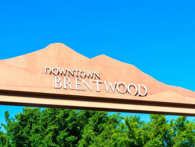
The welcome sign in Downtown Brentwood
The Mount Diablo Sunset from Marsh Creek Reservoir
Median Household Income
$132,532
Average: $153,826
Education
18,908
Residents Have a Degree
Job Market
31,761
Workers Employed
Median Age
41 Years
Largest Age Group
10-19 Years
Approximately 14% of Residents
Under 20
26%
Over 65
19%
Housing Distribution
Brentwood has more homeowners than renters.

Education Distribution
Review this city's overall education levels.

As of September 2026, the average apartment rent in Brentwood, CA is $2,018 for a studio, $2,219 for one bedroom, $2,818 for two bedrooms, and $3,540 for three bedrooms. Apartment rent in Brentwood has increased by 4.9% in the past year.
Explore how walkable, bikeable, drivable, and transit-friendly Brentwood, CA is for everyday living.
Fairly Walkable
Walkability
Minimal Public Transit
Transit
Moderately Drivable
Drivability
Fairly Bikeable
Bikeability

Public
Grades K-5
885 Students

R. Paul Krey Elementary School
Public
Grades K-5
885 Students
Public
Grades K-5
749 Students
Public
Grades K-5
749 Students
Public
Grades K-5
811 Students

Adams (J. Douglas) Middle School
Public
Grades 6-8
1,197 Students
Public
Grades 6-8
1,197 Students

Public
Grades 6-8
1,047 Students
William B. Bristow Middle School
Public
Grades 6-8
1,223 Students

Public
Grades 6-8
1,223 Students
Public
Grades 9-12
2,566 Students
Public
Grades 9-12
2,566 Students
Public
Grades 9-12
2,836 Students
Public
Grades 9-12
2,836 Students
Public
Grades 9-12
163 Students
 The GreatSchools Rating helps parents compare schools within a state based on a variety of school quality indicators and provides a helpful picture of how effectively each school serves all of its students. Ratings are on a scale of 1 (below average) to 10 (above average) and can include test scores, college readiness, academic progress, advanced courses, equity, discipline and attendance data. We also advise parents to visit schools, consider other information on school performance and programs, and consider family needs as part of the school selection process.
View GreatSchools Rating Methodology
Data provided by
GreatSchools.org
© 2026. All rights reserved.
The GreatSchools Rating helps parents compare schools within a state based on a variety of school quality indicators and provides a helpful picture of how effectively each school serves all of its students. Ratings are on a scale of 1 (below average) to 10 (above average) and can include test scores, college readiness, academic progress, advanced courses, equity, discipline and attendance data. We also advise parents to visit schools, consider other information on school performance and programs, and consider family needs as part of the school selection process.
View GreatSchools Rating Methodology
Data provided by
GreatSchools.org
© 2026. All rights reserved.
† Our analysis of utilities, groceries, transportation, healthcare, home prices, and other goods and services is sourced from the Cost of Living Index, a respected benchmark published by the Council for Community and Economic Research (C2ER) that provides a thorough overview of living expenses across different regions.
Rent data is provided by CoStar Group’s Market Trend reports. As the industry leader in commercial real estate information, analytics, and news, CoStar conducts extensive research to produce and maintain a comprehensive database of commercial real estate information. We combine this data with public record to provide the most up-to-date rental information available.
Consumer goods, services, and home prices are sourced from the Cost of Living Index published by the Council for Community and Economic Research (C2ER). The data on this page is updated quarterly. It was last published in September 2026.
Demographic information comes from Neustar and combines detailed address data with U.S. Census and American Community Survey statistics to produce reliable local estimates.