
-
Monthly Rent
$2,100 - $2,750
-
Bedrooms
1 - 2 bd
-
Bathrooms
1 - 2 ba
-
Square Feet
888 - 1,104 sq ft
Highlights
- Terraza en azotea
- Sala de estar
- Vestidores
- Cubierta
- Control de accesos
- Cocina con isla
- Ascensor
- Balcón
- Vistas
Pricing & Floor Plans
Check Back Soon for Upcoming Availability
| Beds | Baths | Average SF | Availability |
|---|---|---|---|
| 1 Bedroom 1 Bedroom 1 Br | 1 Bath 1 Bath 1 Ba | 908 SF | Call for Availability |
| 2 Bedrooms 2 Bedrooms 2 Br | 2 Baths 2 Baths 2 Ba | 1,104 SF | Call for Availability |
-
Unit 405price $2,100square feet 888availibility Call for Availability
-
Unit 411price $2,150square feet 928availibility Call for Availability
-
Unit 413price $2,600square feet 1,104availibility Call for Availability
Fees and Policies
The fees listed below are community-provided and may exclude utilities or add-ons. All payments are made directly to the property and are non-refundable unless otherwise specified.
-
One-Time Basics
-
Application Fee Per ApplicantCharged per unit.$60
-
Administrative Fee$0
-
-
Dogs
-
Pet FeeCharged per pet.$50 / mo
50 lbs. Weight Limit, Pet interview, Spayed/Neutered -
-
Cats
-
Pet FeeMax of 1. Charged per pet.$50 / mo
30 lbs. Weight Limit, Pet interview, Spayed/Neutered -
-
Parking
-
Parking FeeCharged per vehicle.$125 / mo
-
-
Additional Parking Options
-
Surface LotParking Available
-
CoveredParking Available
-
-
Storage Unit
-
Storage RentCharged per rentable item.$0 / mo
-
Property Fee Disclaimer: Based on community-supplied data and independent market research. Subject to change without notice. May exclude fees for mandatory or optional services and usage-based utilities.
Details
Utilities Included
-
Water
-
Trash Removal
-
Sewer
Lease Options
-
Contratos de arrendamiento de 12 - 18 meses
Property Information
-
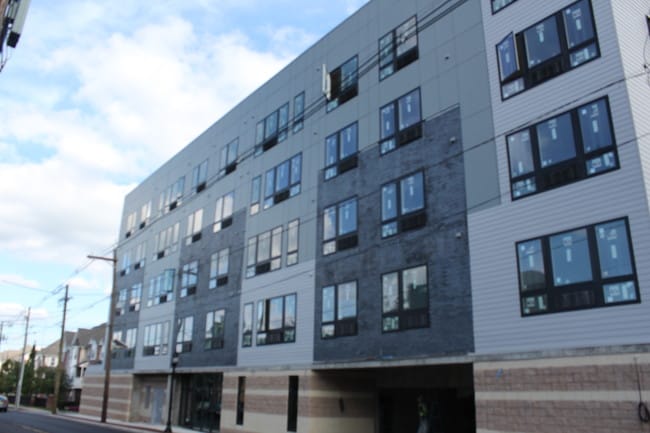
Built in 2018
-
60 units/4 stories
Matterport 3D Tours
About Lexington at Carteret
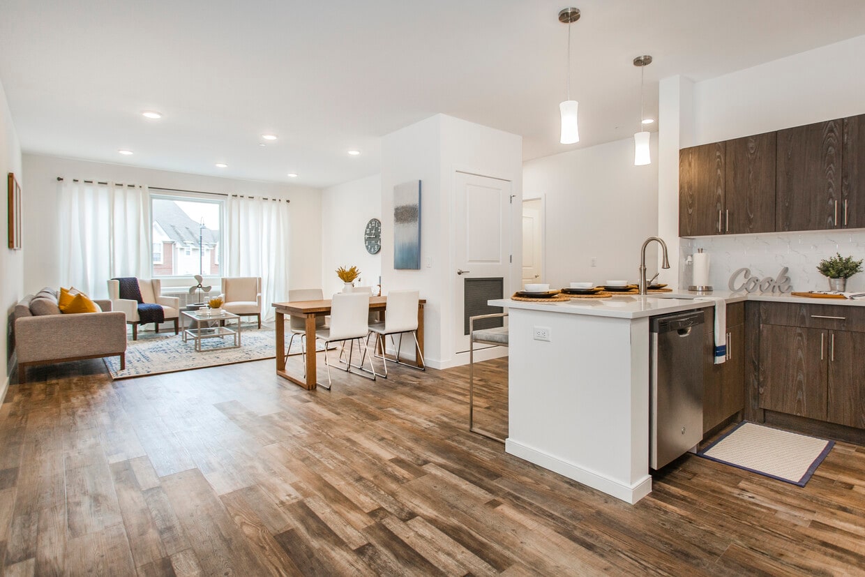
Lexington of Carteret ofrece el encanto de un estilo de vida suburbano con servicios y comodidades de lujo. Considerado a menudo una joya escondida para familias, Carteret se ubica en el extremo norte del condado de Middlesex, a orillas del río Arthur Kill, que ofrece hermosas vistas panorámicas. Las comodidades interiores incluyen un gimnasio con equipos de última generación, un amplio salón para residentes con Wi-Fi y una gran televisión, así como un centro de negocios. Todos los paquetes se guardan en una sala de paquetería segura. Hay un estacionamiento disponible para los residentes. Disfrute de la hermosa terraza al aire libre en la azotea con vistas panorámicas de la ciudad de Nueva York y el río Arthur Kill. Los apartamentos incluyen acabados exquisitos, como encimeras de cuarzo, electrodomésticos de acero inoxidable, lavadora y secadora de tamaño completo y mucho más. Se admiten mascotas, tanto gatos como perros pequeños. Los residentes se sentirán seguros en todo momento gracias al sistema de acceso mediante llavero electrónico de alta tecnología, que permite el acceso tanto a la propiedad como a cada apartamento. Un conserje está disponible para atender las solicitudes de mantenimiento cuando sea necesario. Nueva York es fácilmente accesible gracias a las estaciones de transporte público cercanas y las rutas de autobús directas a la Terminal de Autobuses de la Autoridad Portuaria de Nueva York. Lexington at Carteret se encuentra cerca de numerosos parques, escuelas, centros comerciales y restaurantes.
Lexington at Carteret is an apartment community located in Middlesex County and the 07008 ZIP Code. This area is served by the Carteret Public attendance zone.
Unique Features
- Terraza en azotea
- Terraza y salón al aire libre en la azotea
- Sala fitness, sala de paquetes
- Centro de negocios, gimnasio, terraza en la azotea
- Membresía a RWJ Fitness y bienestar
- Garaje, terraza en la azotea, gimnasio.
- Membresía al centro de bienestar RWJ incluida
Community Amenities
Gimnasio
Ascensor
Terraza en azotea
Control de accesos
- Servicio paquetería
- Control de accesos
- Mantenimiento in situ
- Videovigilancia
- Acceso de minusválidos
- Ascensor
- Centro de negocios
- Salón
- Sala multiusos
- Tolva de residuos
- Gimnasio
- Terraza en azotea
- Patio
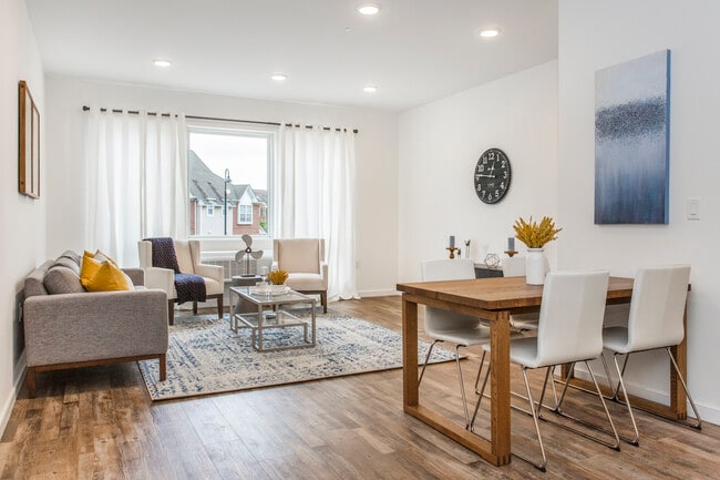
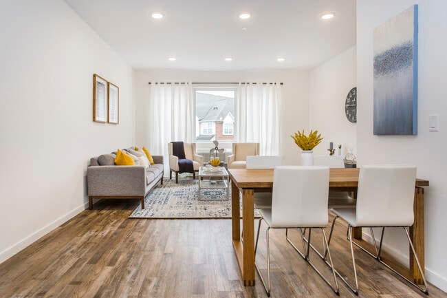
Apartment Features
Lavadora/Secadora
Aire acondicionado
Lavavajillas
Acceso a Internet de alta velocidad
Suelos de madera maciza
Vestidores
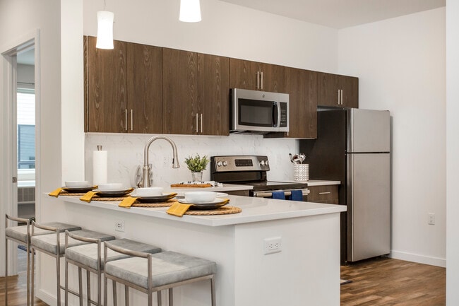
Cocina con isla
Encimeras de granito
Indoor Features
- Acceso a Internet de alta velocidad
- Wifi
- Lavadora/Secadora
- Aire acondicionado
- Calefacción
- Ventiladores de techo
- Libre de humo
- Preinstalación de cables
- Tocadores dobles
- Bañera/Ducha
- Sistema de rociadores
Kitchen Features & Appliances
- Lavavajillas
- Encimeras de granito
- Electrodomésticos de acero inoxidable
- Cocina con isla
- Cocina comedor
- Cocina
- Microondas
- Horno
- Fogón
- Nevera
- Congelador
- Rincón para el desayuno
Model Details
- Suelos de madera maciza
- Suelos de baldosas
- Suelos de vinilo
- Comedor
- Sala familiar
- Sala de entretenimiento
- Sala de estar
- Vistas
- Vestidores
- Armario de ropa blanca
- Ventanas de doble panel
- Cubiertas de ventanas
- Dormitorios grandes
- Balcón
- Cubierta
Located directly across the Arthur Kill from Staten Island, Carteret was once part of the Woodbridge Township. It became the borough of Roosevelt in 1906 and was renamed Carteret in 1922. This popular community is bordered by the Rahway River to the north, Arthur Kill to the east, and the Ernest L. Oros Wildlife Preserve to the west. Due to its central location, the borough bills itself as the "Center of it All."
Residents enjoy a fantastic location and beautiful parks. Carteret Waterfront Park has a fishing pier and access to two hiking trails: Danielle's Garden Trail and the Waterfront Fitness Trail. Shopping in Carteret is plentiful -- the brick-paved sidewalks and outdoor cafes along Washington Avenue provide historic charm and locally-owned businesses, while the shops and restaurants along Roosevelt Avenue have a more modern feel. With just 22 miles to Manhattan, 10 miles to Newark, and 70 miles to Philadelphia, residents can easily commute to nearby cities.
Learn more about living in Carteret- Servicio paquetería
- Control de accesos
- Mantenimiento in situ
- Videovigilancia
- Acceso de minusválidos
- Ascensor
- Centro de negocios
- Salón
- Sala multiusos
- Tolva de residuos
- Terraza en azotea
- Patio
- Gimnasio
- Terraza en azotea
- Terraza y salón al aire libre en la azotea
- Sala fitness, sala de paquetes
- Centro de negocios, gimnasio, terraza en la azotea
- Membresía a RWJ Fitness y bienestar
- Garaje, terraza en la azotea, gimnasio.
- Membresía al centro de bienestar RWJ incluida
- Acceso a Internet de alta velocidad
- Wifi
- Lavadora/Secadora
- Aire acondicionado
- Calefacción
- Ventiladores de techo
- Libre de humo
- Preinstalación de cables
- Tocadores dobles
- Bañera/Ducha
- Sistema de rociadores
- Lavavajillas
- Encimeras de granito
- Electrodomésticos de acero inoxidable
- Cocina con isla
- Cocina comedor
- Cocina
- Microondas
- Horno
- Fogón
- Nevera
- Congelador
- Rincón para el desayuno
- Suelos de madera maciza
- Suelos de baldosas
- Suelos de vinilo
- Comedor
- Sala familiar
- Sala de entretenimiento
- Sala de estar
- Vistas
- Vestidores
- Armario de ropa blanca
- Ventanas de doble panel
- Cubiertas de ventanas
- Dormitorios grandes
- Balcón
- Cubierta
| Monday | By Appointment |
|---|---|
| Tuesday | By Appointment |
| Wednesday | By Appointment |
| Thursday | By Appointment |
| Friday | By Appointment |
| Saturday | By Appointment |
| Sunday | By Appointment |
| Colleges & Universities | Distance | ||
|---|---|---|---|
| Colleges & Universities | Distance | ||
| Drive: | 15 min | 7.9 mi | |
| Drive: | 18 min | 9.6 mi | |
| Drive: | 19 min | 10.8 mi | |
| Drive: | 23 min | 13.8 mi |


View GreatSchools Rating Methodology
Data provided by GreatSchools.org © 2026. All rights reserved.
Transportation options available in Carteret include 8Th Street Light Rail Station, located 12.4 miles from Lexington at Carteret. Lexington at Carteret is near Newark Liberty International, located 14.0 miles or 22 minutes away, and LaGuardia, located 31.4 miles or 51 minutes away.
| Transit / Subway | Distance | ||
|---|---|---|---|
| Transit / Subway | Distance | ||
| Drive: | 20 min | 12.4 mi | |
|
|
Drive: | 22 min | 13.6 mi |
|
|
Drive: | 22 min | 15.3 mi |
|
|
Drive: | 20 min | 15.3 mi |
| Commuter Rail | Distance | ||
|---|---|---|---|
| Commuter Rail | Distance | ||
|
|
Drive: | 7 min | 3.5 mi |
|
|
Drive: | 10 min | 4.7 mi |
|
|
Drive: | 19 min | 9.7 mi |
|
|
Drive: | 20 min | 10.0 mi |
|
|
Drive: | 21 min | 11.3 mi |
| Airports | Distance | ||
|---|---|---|---|
| Airports | Distance | ||
|
Newark Liberty International
|
Drive: | 22 min | 14.0 mi |
|
LaGuardia
|
Drive: | 51 min | 31.4 mi |
Time and distance from Lexington at Carteret.
| Shopping Centers | Distance | ||
|---|---|---|---|
| Shopping Centers | Distance | ||
| Drive: | 3 min | 1.4 mi | |
| Drive: | 4 min | 2.1 mi | |
| Drive: | 20 min | 10.1 mi |
| Parks and Recreation | Distance | ||
|---|---|---|---|
| Parks and Recreation | Distance | ||
|
Liberty State Park
|
Drive: | 6 min | 2.8 mi |
|
Hawk Rise Sanctuary
|
Drive: | 13 min | 6.2 mi |
|
Bloomingdale Park
|
Drive: | 17 min | 8.9 mi |
|
Clay Pit Ponds State Park Preserve
|
Drive: | 20 min | 9.4 mi |
|
Freshkills Park
|
Drive: | 23 min | 12.3 mi |
| Hospitals | Distance | ||
|---|---|---|---|
| Hospitals | Distance | ||
| Drive: | 13 min | 6.2 mi | |
| Drive: | 13 min | 6.4 mi | |
| Drive: | 17 min | 8.2 mi |
| Military Bases | Distance | ||
|---|---|---|---|
| Military Bases | Distance | ||
| Drive: | 20 min | 9.2 mi | |
| Drive: | 23 min | 9.9 mi | |
| Drive: | 27 min | 15.4 mi |
Lexington at Carteret Photos
-
Lexington at Carteret
-
2 habitaciones, 2 baños - 1.104 pies cuadrados
-
-
Lexington of Carteret
-
-
-
-
-
Lexington at Carteret has units with in‑unit washers and dryers, making laundry day simple for residents.
Select utilities are included in rent at Lexington at Carteret, including water, trash removal, and sewer. Residents are responsible for any other utilities not listed.
Parking is available at Lexington at Carteret. Fees may apply depending on the type of parking offered. Contact this property for details.
Yes, Lexington at Carteret welcomes pets. Breed restrictions, weight limits, and additional fees may apply. View this property's pet policy.
A good rule of thumb is to spend no more than 30% of your gross income on rent. Based on the lowest available rent of $2,100 for a one-bedroom, you would need to earn about $84,000 per year to qualify. Want to double-check your budget? Calculate how much rent you can afford with our Rent Affordability Calculator.
Lexington at Carteret is not currently offering any rent specials. Check back soon, as promotions change frequently.
Yes! Lexington at Carteret offers 2 Matterport 3D Tours. Explore different floor plans and see unit level details, all without leaving home.
Statewide service is free, confidential, multilingual and always open. Three easy ways to reach Social Services in NJ: Dial 2-1-1; text your zip code to 898-211; or chat at https://www.nj211.org
What Are Walk Score®, Transit Score®, and Bike Score® Ratings?
Walk Score® measures the walkability of any address. Transit Score® measures access to public transit. Bike Score® measures the bikeability of any address.
What is a Sound Score Rating?
A Sound Score Rating aggregates noise caused by vehicle traffic, airplane traffic and local sources
180 Roosevelt Ave
Carteret, NJ 07008
Property Manager Responded