
57 Eleven Kennedy
5711 John F. Kennedy Blvd,
North Bergen, NJ 07047
Studio - 2 Beds $2,000 - $3,900


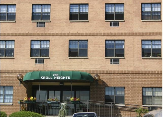
Discover your new place at Kroll Heights in Secaucus. The 700 County Ave location in Secaucus's 07094 area is an ideal place to move. The leasing staff is ready for you to visit. Schedule a time to see the available floorplan options. Come see Kroll Heights today.
Kroll Heights is an apartment community located in Hudson County and the 07094 ZIP Code. This area is served by the Secaucus Board Of Education attendance zone.
24 Hour Access
Public Transportation
Individual Locking Bedrooms
Private Bathroom
Air Conditioning
Microwave
Tub/Shower
Heating
Nestled alongside the Hackensack River within the New Jersey Meadowlands, Secaucus is a dynamic suburb just five miles west of Midtown Manhattan. Secaucus residents enjoy a bevy of shopping opportunities in town, with popular retail centers like the Plaza at Harmon Meadow and the Secaucus Outlet Center providing a host of brand-name delights.
Despite Secaucus’ close proximity to Manhattan, the town maintains a distinct suburban vibe, with plenty of lush green space to relieve any urban anxiety and a host of convenient stores and restaurants for everyday needs. Among the town’s most popular venues for outdoor activities are Laurel Hill Park, Buchmuller Park, and Mill Creek Point Park.
Secaucus is also adjacent to the Meadowlands Sports Complex. Getting around from Secaucus is easy with convenience to I-95, the Frank R. Lautenberg Rail Station, and the Lincoln Tunnel.
Learn more about living in Secaucus| Colleges & Universities | Distance | ||
|---|---|---|---|
| Colleges & Universities | Distance | ||
| Drive: | 12 min | 4.8 mi | |
| Drive: | 8 min | 5.0 mi | |
| Drive: | 10 min | 5.4 mi | |
| Drive: | 16 min | 6.2 mi |


Transportation options available in Secaucus include Tonnelle Avenue, located 2.0 miles from Kroll Heights. Kroll Heights is near Newark Liberty International, located 9.6 miles or 11 minutes away, and LaGuardia, located 14.5 miles or 31 minutes away.
| Transit / Subway | Distance | ||
|---|---|---|---|
| Transit / Subway | Distance | ||
|
|
Drive: | 3 min | 2.0 mi |
|
|
Drive: | 5 min | 2.7 mi |
|
|
Drive: | 6 min | 3.3 mi |
|
|
Drive: | 9 min | 4.5 mi |
|
|
Drive: | 11 min | 4.8 mi |
| Commuter Rail | Distance | ||
|---|---|---|---|
| Commuter Rail | Distance | ||
| Drive: | 7 min | 3.6 mi | |
|
|
Drive: | 8 min | 3.8 mi |
|
|
Drive: | 8 min | 5.0 mi |
|
|
Drive: | 8 min | 5.1 mi |
|
|
Drive: | 12 min | 6.7 mi |
| Airports | Distance | ||
|---|---|---|---|
| Airports | Distance | ||
|
Newark Liberty International
|
Drive: | 11 min | 9.6 mi |
|
LaGuardia
|
Drive: | 31 min | 14.5 mi |
Time and distance from Kroll Heights.
| Shopping Centers | Distance | ||
|---|---|---|---|
| Shopping Centers | Distance | ||
| Walk: | 10 min | 0.6 mi | |
| Walk: | 12 min | 0.6 mi | |
| Drive: | 4 min | 1.7 mi |
| Parks and Recreation | Distance | ||
|---|---|---|---|
| Parks and Recreation | Distance | ||
|
Laurel Hill Park
|
Drive: | 6 min | 2.5 mi |
|
De Witt Clinton Park
|
Drive: | 15 min | 6.3 mi |
|
Meadowlands Environment Center
|
Drive: | 17 min | 7.3 mi |
|
McDowell Observatory
|
Drive: | 17 min | 7.3 mi |
|
Richard W. DeKorte Park
|
Drive: | 16 min | 8.7 mi |
| Hospitals | Distance | ||
|---|---|---|---|
| Hospitals | Distance | ||
| Walk: | 3 min | 0.2 mi | |
| Drive: | 4 min | 1.6 mi | |
| Drive: | 11 min | 4.8 mi |
| Military Bases | Distance | ||
|---|---|---|---|
| Military Bases | Distance | ||
| Drive: | 20 min | 10.2 mi | |
| Drive: | 19 min | 12.5 mi |
What Are Walk Score®, Transit Score®, and Bike Score® Ratings?
Walk Score® measures the walkability of any address. Transit Score® measures access to public transit. Bike Score® measures the bikeability of any address.
What is a Sound Score Rating?
A Sound Score Rating aggregates noise caused by vehicle traffic, airplane traffic and local sources
700 County Ave
Secaucus, NJ 07094


