
-
Monthly Rent
$945 - $1,475
-
Bedrooms
Studio - 2 bd
-
Bathrooms
1 - 2 ba
-
Square Feet
468 - 828 sq ft
Highlights
- High Ceilings
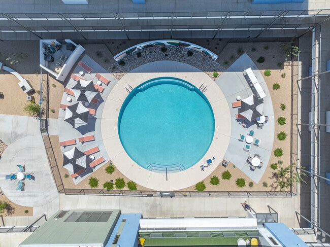
- Pool
- Walk-In Closets
- Spa
- Pet Play Area
- Controlled Access
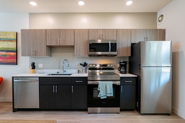
- Island Kitchen
- Dog Park
- Gated
Pricing & Floor Plans
-
Unit 1302price $1,199Unit Specialsquare feet 468availibility Now
-
Unit 2404price $1,099Unit Specialsquare feet 468availibility Mar 14
-
Unit 1303price $1,099Unit Specialsquare feet 468availibility Mar 16
-
Unit 2419price $1,299Unit Specialsquare feet 624availibility Now
-
Unit 2109price $1,299Unit Specialsquare feet 624availibility Now
-
Unit 2108price $1,299Unit Specialsquare feet 624availibility Now
-
Unit 3110price $1,475Unit Specialsquare feet 828availibility Now
-
Unit 3122price $1,475Unit Specialsquare feet 828availibility Now
-
Unit 3207price $1,475Unit Specialsquare feet 828availibility Now
-
Unit 1302price $1,199Unit Specialsquare feet 468availibility Now
-
Unit 2404price $1,099Unit Specialsquare feet 468availibility Mar 14
-
Unit 1303price $1,099Unit Specialsquare feet 468availibility Mar 16
-
Unit 2419price $1,299Unit Specialsquare feet 624availibility Now
-
Unit 2109price $1,299Unit Specialsquare feet 624availibility Now
-
Unit 2108price $1,299Unit Specialsquare feet 624availibility Now
-
Unit 3110price $1,475Unit Specialsquare feet 828availibility Now
-
Unit 3122price $1,475Unit Specialsquare feet 828availibility Now
-
Unit 3207price $1,475Unit Specialsquare feet 828availibility Now
Fees and Policies
The fees listed below are community-provided and may exclude utilities or add-ons. All payments are made directly to the property and are non-refundable unless otherwise specified. Use the Cost Calculator to determine costs based on your needs.
-
One-Time Basics
-
Due at Application
-
Application Fee Per ApplicantCharged per applicant.$75
-
-
Due at Move-In
-
Administrative FeeCharged per unit.$200
-
-
Due at Application
-
Dogs
-
Pet DepositMax of 1. Charged per pet.$200
-
One-Time Pet FeeMax of 1. Charged per pet.$280 - $280
-
Monthly Pet FeeMax of 1. Charged per pet.$50
-
-
Cats
-
Pet DepositMax of 1. Charged per pet.$200
-
One-Time Pet FeeMax of 1. Charged per pet.$280 - $280
-
Monthly Pet FeeMax of 1. Charged per pet.$50
-
-
Covered
-
Parking DepositCharged per vehicle.$0
-
Parking FeeCharged per vehicle.$0
-
Property Fee Disclaimer: Based on community-supplied data and independent market research. Subject to change without notice. May exclude fees for mandatory or optional services and usage-based utilities.
Details
Lease Options
-
12 mo
Property Information
-
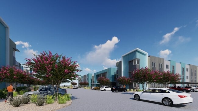
Built in 2023
-
292 units/3 stories
Matterport 3D Tour
About Horizon North
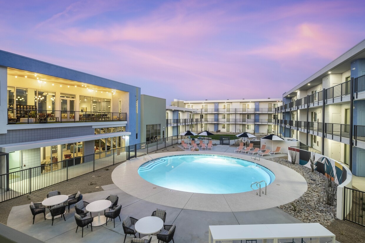
Welcome home to Horizon North Apartments, a community designed for comfort and connection. Our thoughtfully crafted one- and two-bedroom floor plans feature open layouts, modern kitchens, and private patios or balconies. Whether you’re relaxing by the resort-style pool, staying active in the 24-hour fitness center, or gathering with neighbors in the clubhouse, Horizon North offers spaces that make every day feel elevated. Located near major highways and top employers, Horizon North combines the best of convenience and style. You’ll be just minutes from shopping, dining, entertainment, and outdoor recreation, making it easy to balance work and play. Pet-friendly policies, dedicated management, and on-site maintenance ensure your living experience is seamless from day one. Come see why Horizon North is more than just an apartment—it’s your place to thrive. Schedule a tour today and experience apartment living redefined.
Horizon North is an apartment community located in Maricopa County and the 85085 ZIP Code. This area is served by the Deer Valley Unified District attendance zone.
Unique Features
- Shops At Norterra
- Close To Tsmc
- Gold Field
Community Amenities
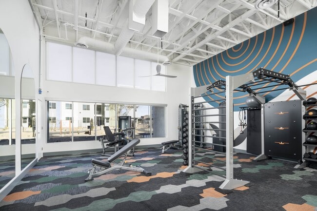
Pool
Fitness Center
Playground
Clubhouse
Controlled Access
Grill
Gated
24 Hour Access
Property Services
- Package Service
- Wi-Fi
- Controlled Access
- Maintenance on site
- Property Manager on Site
- 24 Hour Access
- Renters Insurance Program
- Online Services
- Pet Play Area
- EV Charging
- Wheelchair Accessible
Shared Community
- Clubhouse
- Lounge
- Multi Use Room
Fitness & Recreation
- Fitness Center
- Hot Tub
- Spa
- Pool
- Playground
- Bicycle Storage
Outdoor Features
- Gated
- Courtyard
- Grill
- Dog Park
Apartment Features
Washer/Dryer
Air Conditioning
Dishwasher
High Speed Internet Access
Hardwood Floors
Walk-In Closets
Island Kitchen
Microwave
Indoor Features
- High Speed Internet Access
- Wi-Fi
- Washer/Dryer
- Air Conditioning
- Heating
- Ceiling Fans
- Smoke Free
- Cable Ready
- Tub/Shower
Kitchen Features & Appliances
- Dishwasher
- Disposal
- Ice Maker
- Stainless Steel Appliances
- Island Kitchen
- Eat-in Kitchen
- Kitchen
- Microwave
- Oven
- Range
- Refrigerator
- Freezer
- Quartz Countertops
Model Details
- Hardwood Floors
- Vinyl Flooring
- Dining Room
- High Ceilings
- Family Room
- Walk-In Closets
- Linen Closet
- Double Pane Windows
- Window Coverings
- Large Bedrooms
- Balcony
- Patio
Deer Valley is a family-friendly suburb and residential neighborhood that’s constantly evolving. There are abundant outdoor recreational opportunities in Deer Valley because of its proximity to several natural attractions like Deem Hills and Cave Buttes, both known for scenic hiking and mountain biking trails. Residents have easy access to abundant shopping opportunities without having to leave town at places like Deer Valley Towne Center and Bell Towne Plaza. Deer Valley is home to good public schools and is the ideal suburb for those commuting to Downtown Phoenix and beyond, located less than 20 miles south of town along Interstate 17.
Learn more about living in Deer ValleyCompare neighborhood and city base rent averages by bedroom.
| Deer Valley | Phoenix, AZ | |
|---|---|---|
| Studio | $1,182 | $1,085 |
| 1 Bedroom | $1,238 | $1,302 |
| 2 Bedrooms | $1,555 | $1,558 |
| 3 Bedrooms | $2,061 | $2,072 |
- Package Service
- Wi-Fi
- Controlled Access
- Maintenance on site
- Property Manager on Site
- 24 Hour Access
- Renters Insurance Program
- Online Services
- Pet Play Area
- EV Charging
- Wheelchair Accessible
- Clubhouse
- Lounge
- Multi Use Room
- Gated
- Courtyard
- Grill
- Dog Park
- Fitness Center
- Hot Tub
- Spa
- Pool
- Playground
- Bicycle Storage
- Shops At Norterra
- Close To Tsmc
- Gold Field
- High Speed Internet Access
- Wi-Fi
- Washer/Dryer
- Air Conditioning
- Heating
- Ceiling Fans
- Smoke Free
- Cable Ready
- Tub/Shower
- Dishwasher
- Disposal
- Ice Maker
- Stainless Steel Appliances
- Island Kitchen
- Eat-in Kitchen
- Kitchen
- Microwave
- Oven
- Range
- Refrigerator
- Freezer
- Quartz Countertops
- Hardwood Floors
- Vinyl Flooring
- Dining Room
- High Ceilings
- Family Room
- Walk-In Closets
- Linen Closet
- Double Pane Windows
- Window Coverings
- Large Bedrooms
- Balcony
- Patio
| Monday | 9am - 5pm |
|---|---|
| Tuesday | 9am - 5pm |
| Wednesday | 9am - 5pm |
| Thursday | 9am - 5pm |
| Friday | 9am - 5pm |
| Saturday | Closed |
| Sunday | Closed |
| Colleges & Universities | Distance | ||
|---|---|---|---|
| Colleges & Universities | Distance | ||
| Drive: | 10 min | 5.4 mi | |
| Drive: | 15 min | 8.5 mi | |
| Drive: | 16 min | 9.5 mi | |
| Drive: | 21 min | 11.5 mi |


View GreatSchools Rating Methodology
Data provided by GreatSchools.org © 2026. All rights reserved.
Transportation options available in Phoenix include Metro Pkwy, located 10.5 miles from Horizon North. Horizon North is near Phoenix Sky Harbor International, located 26.5 miles or 36 minutes away.
| Transit / Subway | Distance | ||
|---|---|---|---|
| Transit / Subway | Distance | ||
|
|
Drive: | 15 min | 10.5 mi |
|
|
Drive: | 16 min | 10.8 mi |
|
|
Drive: | 16 min | 11.4 mi |
|
|
Drive: | 17 min | 12.1 mi |
| Airports | Distance | ||
|---|---|---|---|
| Airports | Distance | ||
|
Phoenix Sky Harbor International
|
Drive: | 36 min | 26.5 mi |
Time and distance from Horizon North.
| Shopping Centers | Distance | ||
|---|---|---|---|
| Shopping Centers | Distance | ||
| Walk: | 7 min | 0.4 mi | |
| Walk: | 16 min | 0.9 mi | |
| Drive: | 3 min | 1.2 mi |
| Parks and Recreation | Distance | ||
|---|---|---|---|
| Parks and Recreation | Distance | ||
|
Paseo Highlands Park
|
Drive: | 5 min | 2.8 mi |
|
Adobe Mountain Park
|
Drive: | 8 min | 4.0 mi |
|
Adobe Dam Regional Park
|
Drive: | 7 min | 4.0 mi |
|
Reach 11 Recreation Area
|
Drive: | 13 min | 6.6 mi |
|
Turtle Rock Basin
|
Drive: | 12 min | 6.7 mi |
| Hospitals | Distance | ||
|---|---|---|---|
| Hospitals | Distance | ||
| Drive: | 6 min | 3.1 mi | |
| Drive: | 8 min | 4.2 mi | |
| Drive: | 16 min | 10.0 mi |
| Military Bases | Distance | ||
|---|---|---|---|
| Military Bases | Distance | ||
| Drive: | 34 min | 24.6 mi | |
| Drive: | 36 min | 26.3 mi | |
| Drive: | 114 min | 87.6 mi |
Horizon North Photos
-
Horizon North
-
2BR, 2BA - 828SF
-
-
-
-
-
-
-
Models
-
Studio.jpg
-
Unit 1B.jpg
-
Unit 2B.jpg
Nearby Apartments
Within 50 Miles of Horizon North
-
Sentio
3600 W Happy Valley Rd
Glendale, AZ 85310
$1,127 - $2,582
1-3 Br 2.2 mi
-
The Hillburn
2550 W North Foothills Dr Dr
Phoenix, AZ 85085
$2,555 - $3,375
2-4 Br 4.5 mi
-
Velaire at Aspera
7700 W Aspera Blvd
Glendale, AZ 85308
$1,349 - $2,125
1-3 Br 7.7 mi
-
Canopy at The Trails Townhomes
4141 N 104th Dr
Phoenix, AZ 85037
$2,095 - $2,420
2-3 Br 18.3 mi
-
The Local Tempe Luxury Apartments
750 S Ash Ave
Tempe, AZ 85281
$1,699 - $3,899
1-3 Br 21.8 mi
-
The Hyve
1260 E University Dr
Tempe, AZ 85281
$1,395 - $2,620
1-3 Br 22.5 mi
Horizon North has units with in‑unit washers and dryers, making laundry day simple for residents.
Utilities are not included in rent. Residents should plan to set up and pay for all services separately.
Parking is available at Horizon North and is free of charge for residents.
Horizon North has studios to two-bedrooms with rent ranges from $945/mo. to $1,475/mo.
Yes, Horizon North welcomes pets. Breed restrictions, weight limits, and additional fees may apply. View this property's pet policy.
A good rule of thumb is to spend no more than 30% of your gross income on rent. Based on the lowest available rent of $945 for a studio, you would need to earn about $37,800 per year to qualify. Want to double-check your budget? Calculate how much rent you can afford with our Rent Affordability Calculator.
Horizon North is offering Discounts for eligible applicants, with rental rates starting at $945.
Yes! Horizon North offers 1 Matterport 3D Tours. Explore different floor plans and see unit level details, all without leaving home.
What Are Walk Score®, Transit Score®, and Bike Score® Ratings?
Walk Score® measures the walkability of any address. Transit Score® measures access to public transit. Bike Score® measures the bikeability of any address.
What is a Sound Score Rating?
A Sound Score Rating aggregates noise caused by vehicle traffic, airplane traffic and local sources
24825 N 19th Ave
Phoenix, AZ 85085
Property Manager Responded