
1213 Walnut
1213 Walnut St,
Philadelphia, PA 19107
$1,980 - $5,270
Studio - 2 Beds


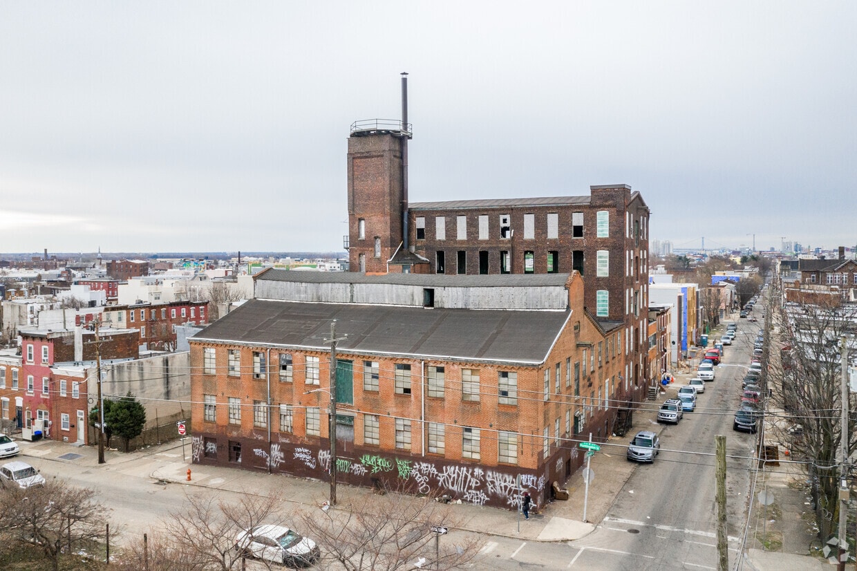
Thanks for your interest in 178-80 W Huntingdon St. This property is situated in the North Philadelphia East area of Philadelphia. Let the leasing team show you everything this community has to offer. It's time to come home to 178-80 W Huntingdon St. Contact us or stop by the leasing office to discuss your new apartment.
Hancock Lofts is an apartment community located in Philadelphia County and the 19133 ZIP Code. This area is served by the The School District of Philadelphia attendance zone.
Elevator
Controlled Access
24 Hour Access
Public Transportation
Air Conditioning
Refrigerator
Tub/Shower
Oven
Not to be confused with Northeast Philadelphia, North Philadelphia East encompasses the smaller subsets of Ludlow, Yorktown, West Kensington, Poplar, and Callowhill. This composite area runs from the Vine Street Expressway, stretching north to Erie Avenue. Broad Street acts as its eastern border, and the western edge runs a jagged line separating North Philadelphia East from the nearby Kensington, Port Richmond, and Fishtown neighborhoods. With such a long stretch of city, the neighborhood offers a diverse blend of important city landmarks, such as renowned musical venues the Electric Factory and Union Transfer, and Temple University, North Philadelphia's premiere site of higher learning.
Learn more about living in North Philadelphia East| Colleges & Universities | Distance | ||
|---|---|---|---|
| Colleges & Universities | Distance | ||
| Drive: | 4 min | 1.8 mi | |
| Drive: | 6 min | 2.2 mi | |
| Drive: | 8 min | 3.6 mi | |
| Drive: | 10 min | 3.7 mi |


Transportation options available in Philadelphia include Huntingdon, located 0.4 mile from Hancock Lofts. Hancock Lofts is near Philadelphia International, located 15.1 miles or 25 minutes away, and Trenton Mercer, located 32.0 miles or 48 minutes away.
| Transit / Subway | Distance | ||
|---|---|---|---|
| Transit / Subway | Distance | ||
|
|
Walk: | 7 min | 0.4 mi |
|
|
Walk: | 9 min | 0.5 mi |
|
|
Walk: | 13 min | 0.7 mi |
|
|
Walk: | 17 min | 0.9 mi |
|
|
Drive: | 3 min | 1.4 mi |
| Commuter Rail | Distance | ||
|---|---|---|---|
| Commuter Rail | Distance | ||
|
|
Drive: | 3 min | 1.4 mi |
|
|
Drive: | 4 min | 1.4 mi |
|
|
Drive: | 4 min | 1.6 mi |
|
|
Drive: | 5 min | 1.8 mi |
|
|
Drive: | 5 min | 2.4 mi |
| Airports | Distance | ||
|---|---|---|---|
| Airports | Distance | ||
|
Philadelphia International
|
Drive: | 25 min | 15.1 mi |
|
Trenton Mercer
|
Drive: | 48 min | 32.0 mi |
Time and distance from Hancock Lofts.
| Shopping Centers | Distance | ||
|---|---|---|---|
| Shopping Centers | Distance | ||
| Walk: | 14 min | 0.7 mi | |
| Drive: | 4 min | 1.3 mi | |
| Drive: | 4 min | 1.8 mi |
| Parks and Recreation | Distance | ||
|---|---|---|---|
| Parks and Recreation | Distance | ||
|
Wagner Free Institute of Science
|
Drive: | 7 min | 2.3 mi |
|
Edgar Allan Poe Nat'l Historic Site
|
Drive: | 7 min | 2.7 mi |
|
Great Egg Harbor River
|
Drive: | 8 min | 3.0 mi |
|
Independence National Historical Park
|
Drive: | 8 min | 3.2 mi |
|
Tacony Creek Park
|
Drive: | 9 min | 4.3 mi |
| Hospitals | Distance | ||
|---|---|---|---|
| Hospitals | Distance | ||
| Drive: | 4 min | 1.6 mi | |
| Drive: | 4 min | 1.9 mi | |
| Drive: | 5 min | 2.1 mi |
| Military Bases | Distance | ||
|---|---|---|---|
| Military Bases | Distance | ||
| Drive: | 16 min | 9.5 mi |
What Are Walk Score®, Transit Score®, and Bike Score® Ratings?
Walk Score® measures the walkability of any address. Transit Score® measures access to public transit. Bike Score® measures the bikeability of any address.
What is a Sound Score Rating?
A Sound Score Rating aggregates noise caused by vehicle traffic, airplane traffic and local sources
178-80 W Huntingdon St
Philadelphia, PA 19133


