
MAA Addison Circle
5009 Addison Cir,
Addison, TX 75001
$1,115 - $4,780
Studio - 2 Beds
Bedrooms
1 - 3 bd
Bathrooms
1 - 2 ba
Square Feet
732 - 1,379 sq ft
Located in the top-rated Carrollton-Farmers Branch ISD, our Farmers Branch apartments offer a world of opportunity – just outside the heart of the Metroplex. Upscale comforts like granite or quartz countertops, lakeside views, and modern lighting will make you proud to call any of our one, two, or three-bedroom apartments for rent in Downtown Las Colinas home. With convenience to major employers like UT Southwestern and American Airlines, our Farmers Branch apartment community makes your everyday commute a breeze. And when you’re considering your weekend plans, you have plenty of options nearby. Tee off at TPC Four Seasons Las Colinas, or go for a sunny jog on our scenic nature trails. Then, explore all the shopping, dining, and entertainment of Toyota Music Factory, or hop on I-35E for an easy drive into Downtown Dallas. No matter what your day looks like, you’ll come home to the hospitality and service of a community team dedicated to you.
Cortland Waters Edge is an apartment community located in Dallas County and the 75229 ZIP Code. This area is served by the Carrollton-Farmers Branch Independent School District attendance zone.
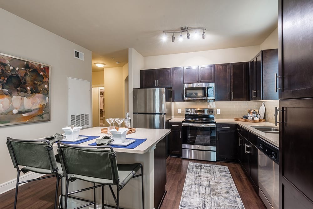
Unique Features
Pool
Fitness Center
Laundry Facilities
Clubhouse
Located in the Dallas-Fort Worth metroplex, Farmers Branch combines residential comfort with easy access to city amenities. The city's extensive parks and green spaces have earned it the nickname "The City in a Park." With approximately 36,000 residents, Farmers Branch offers various rental options, from studios averaging $1,359 monthly to three-bedroom homes at $2,434. The DART light rail station area and the historic district near the original settlement feature established residential communities, while providing convenient access to downtown Dallas.
Farmers Branch traces its roots to the 1850s, when settlers Thomas Keenan, Isaac B. Webb, and William Cochran established the community. Originally called Mustang Branch, the name later changed to reflect the area's farming heritage. Today, the city serves as headquarters for more than 3,500 businesses, including Celanese Corporation and OxyChem.
Learn more about living in Farmers BranchCompare neighborhood and city base rent averages by bedroom.
| Koreatown/Gribble | Farmers Branch, TX | |
|---|---|---|
| Studio | $1,385 | $1,361 |
| 1 Bedroom | $1,398 | $1,526 |
| 2 Bedrooms | $1,885 | $1,977 |
| 3 Bedrooms | $2,121 | $2,474 |
| Colleges & Universities | Distance | ||
|---|---|---|---|
| Colleges & Universities | Distance | ||
| Drive: | 6 min | 2.9 mi | |
| Drive: | 10 min | 4.2 mi | |
| Drive: | 11 min | 5.3 mi | |
| Drive: | 10 min | 6.2 mi |


Transportation options available in Farmers Branch include Royal Lane Station, located 2.0 miles from Cortland Waters Edge. Cortland Waters Edge is near Dallas Love Field, located 9.7 miles or 17 minutes away, and Dallas-Fort Worth International, located 11.0 miles or 18 minutes away.
| Transit / Subway | Distance | ||
|---|---|---|---|
| Transit / Subway | Distance | ||
|
|
Drive: | 4 min | 2.0 mi |
|
|
Drive: | 7 min | 3.1 mi |
|
|
Drive: | 6 min | 3.1 mi |
|
|
Drive: | 6 min | 3.2 mi |
|
|
Drive: | 7 min | 3.5 mi |
| Commuter Rail | Distance | ||
|---|---|---|---|
| Commuter Rail | Distance | ||
|
|
Drive: | 11 min | 7.9 mi |
|
|
Drive: | 14 min | 9.2 mi |
|
|
Drive: | 14 min | 9.7 mi |
|
|
Drive: | 16 min | 11.1 mi |
|
|
Drive: | 17 min | 12.5 mi |
| Airports | Distance | ||
|---|---|---|---|
| Airports | Distance | ||
|
Dallas Love Field
|
Drive: | 17 min | 9.7 mi |
|
Dallas-Fort Worth International
|
Drive: | 18 min | 11.0 mi |
Time and distance from Cortland Waters Edge.
| Shopping Centers | Distance | ||
|---|---|---|---|
| Shopping Centers | Distance | ||
| Drive: | 2 min | 1.1 mi | |
| Drive: | 3 min | 1.2 mi | |
| Drive: | 3 min | 1.3 mi |
| Parks and Recreation | Distance | ||
|---|---|---|---|
| Parks and Recreation | Distance | ||
|
Elm Fork Preserve
|
Drive: | 10 min | 4.8 mi |
|
Grapevine Springs Preserve
|
Drive: | 14 min | 8.1 mi |
|
Coppell Nature Park
|
Drive: | 15 min | 9.1 mi |
|
Coppell Community Garden
|
Drive: | 16 min | 9.5 mi |
|
Beckert Park
|
Drive: | 15 min | 10.3 mi |
| Hospitals | Distance | ||
|---|---|---|---|
| Hospitals | Distance | ||
| Drive: | 5 min | 2.5 mi | |
| Drive: | 5 min | 2.6 mi | |
| Drive: | 6 min | 3.9 mi |
| Military Bases | Distance | ||
|---|---|---|---|
| Military Bases | Distance | ||
| Drive: | 23 min | 15.3 mi | |
| Drive: | 51 min | 36.8 mi |
What Are Walk Score®, Transit Score®, and Bike Score® Ratings?
Walk Score® measures the walkability of any address. Transit Score® measures access to public transit. Bike Score® measures the bikeability of any address.
What is a Sound Score Rating?
A Sound Score Rating aggregates noise caused by vehicle traffic, airplane traffic and local sources.

1701 Royal Ln
Farmers Branch, TX 75229


