Canal House
4312 Main St,
Philadelphia,
PA
19127
-
Monthly Rent
$1,395 - $2,200
-
Bedrooms
1 - 2 bd
-
Bathrooms
1 - 2 ba
-
Square Feet
463 - 1,122 sq ft
Highlights
- By-The-Bed Leasing
- Loft Layout
- Den
- Walk-In Closets
- Controlled Access
- Gated
- Elevator
- Property Manager on Site
- Views
Pricing & Floor Plans
Fees and Policies
The fees listed below are community-provided and may exclude utilities or add-ons. All payments are made directly to the property and are non-refundable unless otherwise specified.
-
One-Time Basics
-
Due at Application
-
Application Fee Per ApplicantCharged per applicant.$45
-
-
Due at Application
-
Dogs
-
Pet DepositMax of 1. Charged per pet.$500
-
Monthly Pet FeeMax of 1. Charged per pet.$35 / mo
80 lbs. Weight LimitRestrictions:Breed restrictions may applyRead More Read Less -
-
Cats
-
Pet DepositMax of 2. Charged per pet.$500
-
Monthly Pet FeeMax of 2. Charged per pet.$35 / mo
-
Property Fee Disclaimer: Based on community-supplied data and independent market research. Subject to change without notice. May exclude fees for mandatory or optional services and usage-based utilities.
Details
Utilities Included
-
Trash Removal
-
Sewer
Lease Options
-
12 mo
Property Information
-
Built in 1988
-
81 units/3 stories
About Canal House
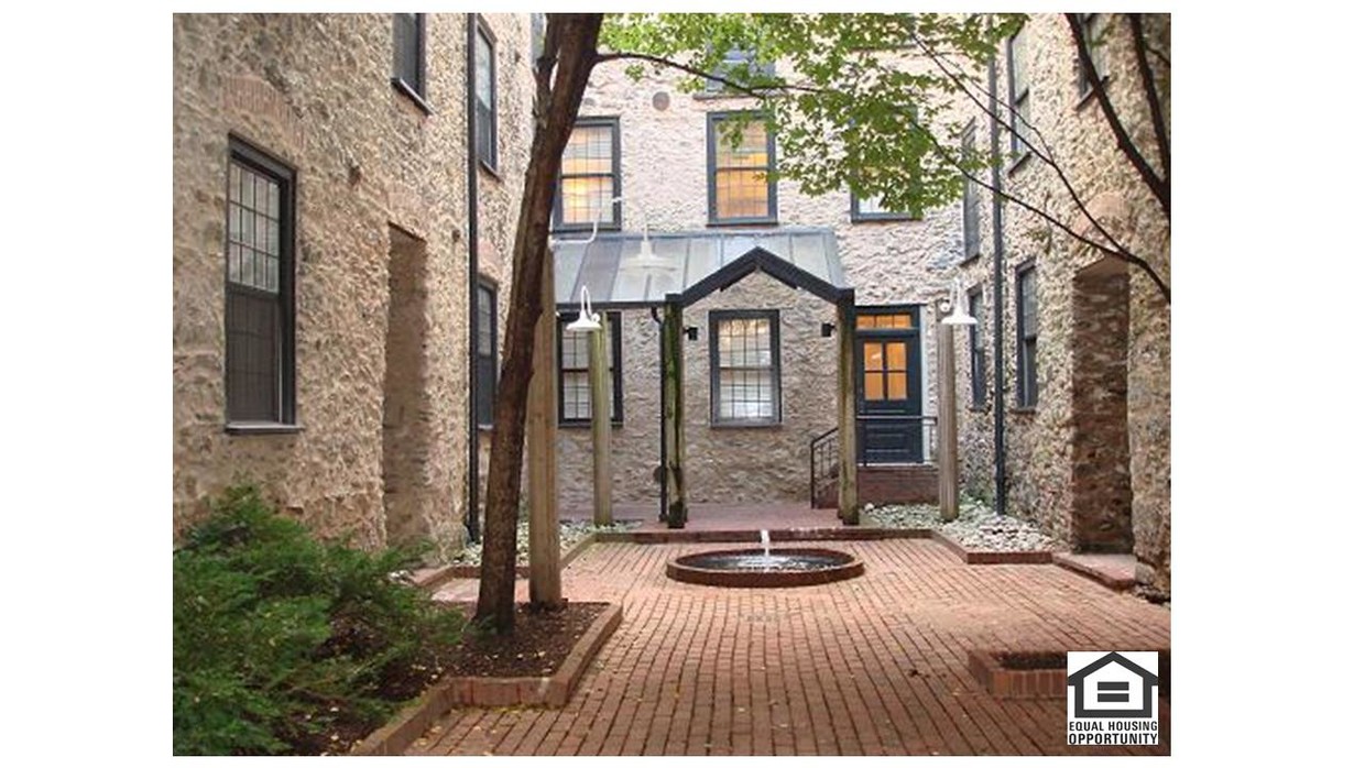
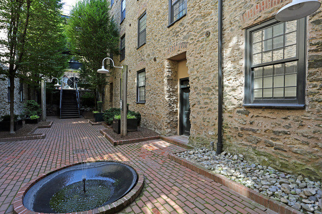
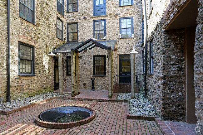
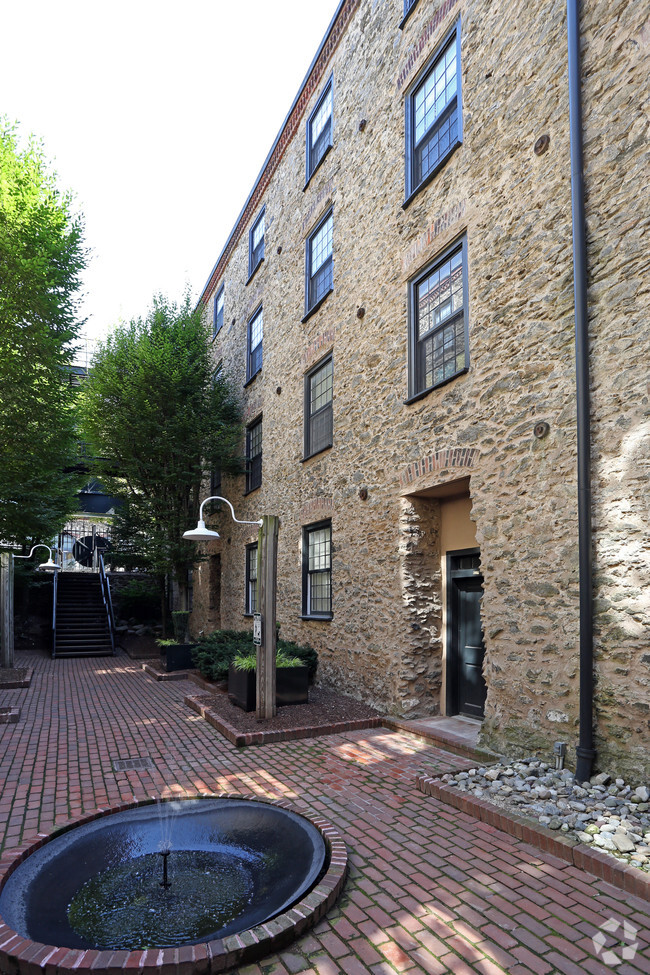
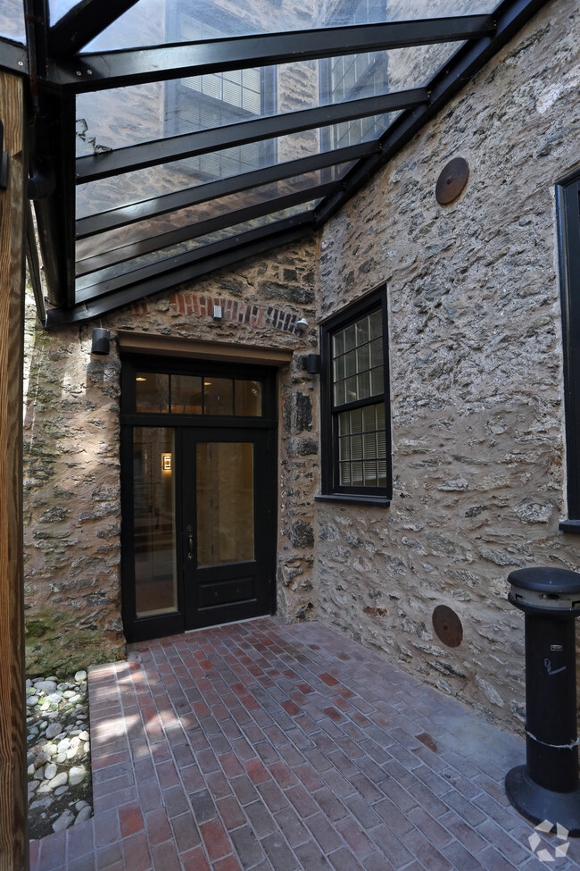
Canal House offers beautifully designed, upscale apartments located in an urban village that's convenient to everything. Built in 1847 as the Blantyre Mills, the building produced woolen blankets for the Union Army during the Civil War. Unique features of Canal House include the gated, landscaped courtyard, oversized windows, and views of the historic Manayunk Canal from most apartments.
Canal House is an apartment community located in Philadelphia County and the 19127 ZIP Code. This area is served by the The School District of Philadelphia attendance zone.
Community Amenities
Laundry Facilities
Elevator
Controlled Access
Gated
- Package Service
- Laundry Facilities
- Controlled Access
- Maintenance on site
- Property Manager on Site
- Elevator
- Vintage Building
- Gated
- Courtyard
Apartment Features
Washer/Dryer
Air Conditioning
Dishwasher
Loft Layout
High Speed Internet Access
Hardwood Floors
Walk-In Closets
Granite Countertops
Indoor Features
- High Speed Internet Access
- Washer/Dryer
- Air Conditioning
- Heating
- Smoke Free
- Cable Ready
- Tub/Shower
- Intercom
- Wheelchair Accessible (Rooms)
Kitchen Features & Appliances
- Dishwasher
- Disposal
- Ice Maker
- Granite Countertops
- Stainless Steel Appliances
- Kitchen
- Microwave
- Range
- Refrigerator
- Breakfast Nook
Model Details
- Hardwood Floors
- Carpet
- Tile Floors
- Dining Room
- Den
- Vaulted Ceiling
- Views
- Walk-In Closets
- Loft Layout
- Window Coverings
Philadelphia sits at the center of American history and still carries that weight with quiet confidence — it's the city where the Declaration of Independence was signed, and today those same streets anchor neighborhoods full of energy and purpose. As Pennsylvania's largest city and the sixth most populous in the country, Philly draws renters with a broad economy spanning healthcare, financial services, biotechnology, and information technology, plus a university presence that includes the University of Pennsylvania, Drexel, Temple, and several other institutions spread across the city.
Neighborhoods here range considerably in character. Old City offers cobblestone streets alongside contemporary gallery spaces, Fishtown pulses with creative industries and converted-warehouse architecture, Rittenhouse Square delivers manicured parks and polished streets, and Manayunk brings a hillside village feel within city limits.
Learn more about living in PhiladelphiaCompare neighborhood and city base rent averages by bedroom.
| Northwest Philadelphia/Manayunk | Philadelphia, PA | |
|---|---|---|
| Studio | $2,916 | $1,408 |
| 1 Bedroom | $3,316 | $1,765 |
| 2 Bedrooms | $3,834 | $2,207 |
| 3 Bedrooms | $3,963 | $2,948 |
- Package Service
- Laundry Facilities
- Controlled Access
- Maintenance on site
- Property Manager on Site
- Elevator
- Vintage Building
- Gated
- Courtyard
- High Speed Internet Access
- Washer/Dryer
- Air Conditioning
- Heating
- Smoke Free
- Cable Ready
- Tub/Shower
- Intercom
- Wheelchair Accessible (Rooms)
- Dishwasher
- Disposal
- Ice Maker
- Granite Countertops
- Stainless Steel Appliances
- Kitchen
- Microwave
- Range
- Refrigerator
- Breakfast Nook
- Hardwood Floors
- Carpet
- Tile Floors
- Dining Room
- Den
- Vaulted Ceiling
- Views
- Walk-In Closets
- Loft Layout
- Window Coverings
| Monday | Closed |
|---|---|
| Tuesday | 9am - 5:30pm |
| Wednesday | 9am - 5:30pm |
| Thursday | 9am - 5:30pm |
| Friday | 9am - 5:30pm |
| Saturday | 10am - 4pm |
| Sunday | Closed |
| Colleges & Universities | Distance | ||
|---|---|---|---|
| Colleges & Universities | Distance | ||
| Drive: | 6 min | 2.2 mi | |
| Drive: | 5 min | 2.6 mi | |
| Drive: | 8 min | 3.0 mi | |
| Drive: | 9 min | 3.5 mi |


View GreatSchools Rating Methodology
Data provided by GreatSchools.org © 2026. All rights reserved.
Transportation options available in Philadelphia include Lancaster Avenue And 52Nd Street, located 4.2 miles from Canal House. Canal House is near Philadelphia International, located 16.3 miles or 29 minutes away, and Trenton Mercer, located 34.1 miles or 57 minutes away.
| Transit / Subway | Distance | ||
|---|---|---|---|
| Transit / Subway | Distance | ||
|
|
Drive: | 10 min | 4.2 mi |
|
|
Drive: | 10 min | 4.4 mi |
|
|
Drive: | 10 min | 4.5 mi |
|
|
Drive: | 10 min | 4.5 mi |
|
|
Drive: | 11 min | 4.7 mi |
| Commuter Rail | Distance | ||
|---|---|---|---|
| Commuter Rail | Distance | ||
|
|
Walk: | 5 min | 0.3 mi |
|
|
Walk: | 20 min | 1.0 mi |
|
|
Drive: | 4 min | 1.3 mi |
|
|
Drive: | 5 min | 1.9 mi |
|
|
Drive: | 6 min | 2.6 mi |
| Airports | Distance | ||
|---|---|---|---|
| Airports | Distance | ||
|
Philadelphia International
|
Drive: | 29 min | 16.3 mi |
|
Trenton Mercer
|
Drive: | 57 min | 34.1 mi |
Scores provided by
Traffic
BusyAirport
CalmBusinesses
ActiveScores provided by
HowLoud What is a Sound Score Rating? A Sound Score Rating aggregates noise caused by vehicle traffic, airplane traffic and local sources. How It WorksTime and distance from Canal House.
| Shopping Centers | Distance | ||
|---|---|---|---|
| Shopping Centers | Distance | ||
| Walk: | 16 min | 0.8 mi | |
| Walk: | 16 min | 0.8 mi | |
| Walk: | 18 min | 0.9 mi |
| Parks and Recreation | Distance | ||
|---|---|---|---|
| Parks and Recreation | Distance | ||
|
Arboretum of the Barnes Foundation
|
Drive: | 8 min | 3.0 mi |
|
Merion Botanical Park
|
Drive: | 9 min | 3.3 mi |
|
Schuylkill Center for Environmental Education
|
Drive: | 11 min | 3.7 mi |
|
Rolling Hill Park
|
Drive: | 10 min | 3.8 mi |
|
Fairmount Park
|
Drive: | 10 min | 3.9 mi |
| Hospitals | Distance | ||
|---|---|---|---|
| Hospitals | Distance | ||
| Walk: | 15 min | 0.8 mi | |
| Drive: | 6 min | 2.0 mi | |
| Drive: | 11 min | 4.8 mi |
| Military Bases | Distance | ||
|---|---|---|---|
| Military Bases | Distance | ||
| Drive: | 22 min | 13.0 mi |
Canal House Photos
-
Canal House
-
Canal House
-
Canal House
-
Canal House
-
Canal House
-
Canal House
-
Address
-
Canal House
-
Canal House
Nearby Apartments
Within 50 Miles of Canal House
Canal House has units with in‑unit washers and dryers, making laundry day simple for residents.
Select utilities are included in rent at Canal House, including trash removal and sewer. Residents are responsible for any other utilities not listed.
Parking is available at Canal House for $120 - $125 / mo. Contact this property for details.
Canal House has one to two-bedrooms with rent ranges from $1,395/mo. to $2,200/mo.
Yes, Canal House welcomes pets. Breed restrictions, weight limits, and additional fees may apply. View this property's pet policy.
A good rule of thumb is to spend no more than 30% of your gross income on rent. Based on the lowest available rent of $1,395 for a one-bedroom, you would need to earn about $55,800 per year to qualify. Want to double-check your budget? Calculate how much rent you can afford with our Rent Affordability Calculator.
Canal House is offering Discounts for eligible applicants, with rental rates starting at $1,395.
While Canal House does not offer Matterport 3D tours, renters can request a tour directly through our online platform.
What Are Walk Score®, Transit Score®, and Bike Score® Ratings?
Walk Score® measures the walkability of any address. Transit Score® measures access to public transit. Bike Score® measures the bikeability of any address.
What is a Sound Score Rating?
A Sound Score Rating aggregates noise caused by vehicle traffic, airplane traffic and local sources.

4312 Main St
Philadelphia, PA 19127