
1213 Walnut
1213 Walnut St,
Philadelphia, PA 19107
$2,375 - $5,019
Studio - 2 Beds
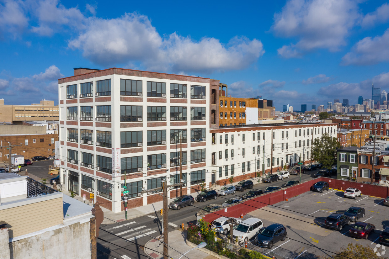
Opened in 1926 as a paintbrush manufacturing facility, Brush Factory Lofts has been transformed into modern apartments with a hint of vintage flair. Each unit boasts stylish finishes and functional features, including hardwood floors, quartz countertops, stainless steel appliances, custom light fixtures, and in-unit washers and dryers.
Brush Factory Lofts is an apartment community located in Philadelphia County and the 19148 ZIP Code. This area is served by the The School District of Philadelphia attendance zone.
Unique Features
Fitness Center
Doorman
Clubhouse
Roof Terrace
Washer/Dryer
Air Conditioning
High Speed Internet Access
Hardwood Floors
South Philadelphia East is a fun yet affordable area comprising of several neighborhoods, most consisting of two- to four-bedroom brick row homes, although there are also plenty of apartments and brand-new condos, particularly along Broad Street. This area houses Passyunk Avenue (pronounced "Passh-yunk" by the locals) that has exploded in recent years with stores, bars with plenty of craft beer, and restaurants, including the high-end Laurel, run by a top chef. The Italian Market is also nearby, a blocks-long outdoor food and produce market, making for easy grocery shopping.
The area is diverse, and you can find newcomers alongside native Philadelphians whose families have lived there for several generations. South Philly-living offers more of a community feel than downtown, yet the Broad Street Line and numerous public transit buses flow through this section, Center City is less than 15 minutes away.
Learn more about living in South Philadelphia EastCompare neighborhood and city base rent averages by bedroom.
| South Philadelphia East | Philadelphia, PA | |
|---|---|---|
| Studio | $2,409 | $1,408 |
| 1 Bedroom | $2,758 | $1,737 |
| 2 Bedrooms | $3,873 | $2,183 |
| 3 Bedrooms | $4,989 | $2,975 |
| Colleges & Universities | Distance | ||
|---|---|---|---|
| Colleges & Universities | Distance | ||
| Drive: | 7 min | 2.2 mi | |
| Drive: | 7 min | 2.5 mi | |
| Drive: | 8 min | 2.9 mi | |
| Drive: | 8 min | 3.1 mi |


Transportation options available in Philadelphia include Snyder, located 0.2 mile from Brush Factory Lofts. Brush Factory Lofts is near Philadelphia International, located 8.4 miles or 17 minutes away, and Trenton Mercer, located 35.6 miles or 54 minutes away.
| Transit / Subway | Distance | ||
|---|---|---|---|
| Transit / Subway | Distance | ||
|
|
Walk: | 4 min | 0.2 mi |
|
|
Walk: | 11 min | 0.6 mi |
|
|
Walk: | 11 min | 0.6 mi |
|
|
Walk: | 19 min | 1.0 mi |
|
|
Drive: | 4 min | 1.6 mi |
| Commuter Rail | Distance | ||
|---|---|---|---|
| Commuter Rail | Distance | ||
|
|
Drive: | 7 min | 2.3 mi |
|
|
Drive: | 7 min | 2.6 mi |
|
|
Drive: | 9 min | 3.3 mi |
| Drive: | 8 min | 4.2 mi | |
| Drive: | 10 min | 4.4 mi |
| Airports | Distance | ||
|---|---|---|---|
| Airports | Distance | ||
|
Philadelphia International
|
Drive: | 17 min | 8.4 mi |
|
Trenton Mercer
|
Drive: | 54 min | 35.6 mi |
Time and distance from Brush Factory Lofts.
| Shopping Centers | Distance | ||
|---|---|---|---|
| Shopping Centers | Distance | ||
| Drive: | 4 min | 1.2 mi | |
| Drive: | 3 min | 1.3 mi | |
| Drive: | 4 min | 1.4 mi |
| Parks and Recreation | Distance | ||
|---|---|---|---|
| Parks and Recreation | Distance | ||
|
Thaddeus Kosciuszko National Memorial
|
Drive: | 6 min | 1.9 mi |
|
Gloria Dei Church National Historic Site
|
Drive: | 5 min | 1.9 mi |
|
Independence Seaport Museum
|
Drive: | 8 min | 2.6 mi |
|
Schuylkill River Park
|
Drive: | 7 min | 2.7 mi |
|
Franklin D. Roosevelt Park
|
Drive: | 8 min | 2.7 mi |
| Hospitals | Distance | ||
|---|---|---|---|
| Hospitals | Distance | ||
| Drive: | 7 min | 2.0 mi | |
| Drive: | 6 min | 2.0 mi | |
| Drive: | 7 min | 2.2 mi |
| Military Bases | Distance | ||
|---|---|---|---|
| Military Bases | Distance | ||
| Drive: | 7 min | 2.8 mi |
What Are Walk Score®, Transit Score®, and Bike Score® Ratings?
Walk Score® measures the walkability of any address. Transit Score® measures access to public transit. Bike Score® measures the bikeability of any address.
What is a Sound Score Rating?
A Sound Score Rating aggregates noise caused by vehicle traffic, airplane traffic and local sources

1201 Jackson St
Philadelphia, PA 19148


