
Hazel National Landing
3030 S Potomac Ave,
Arlington, VA 22202
Studio - 2 Beds $2,135 - $6,599
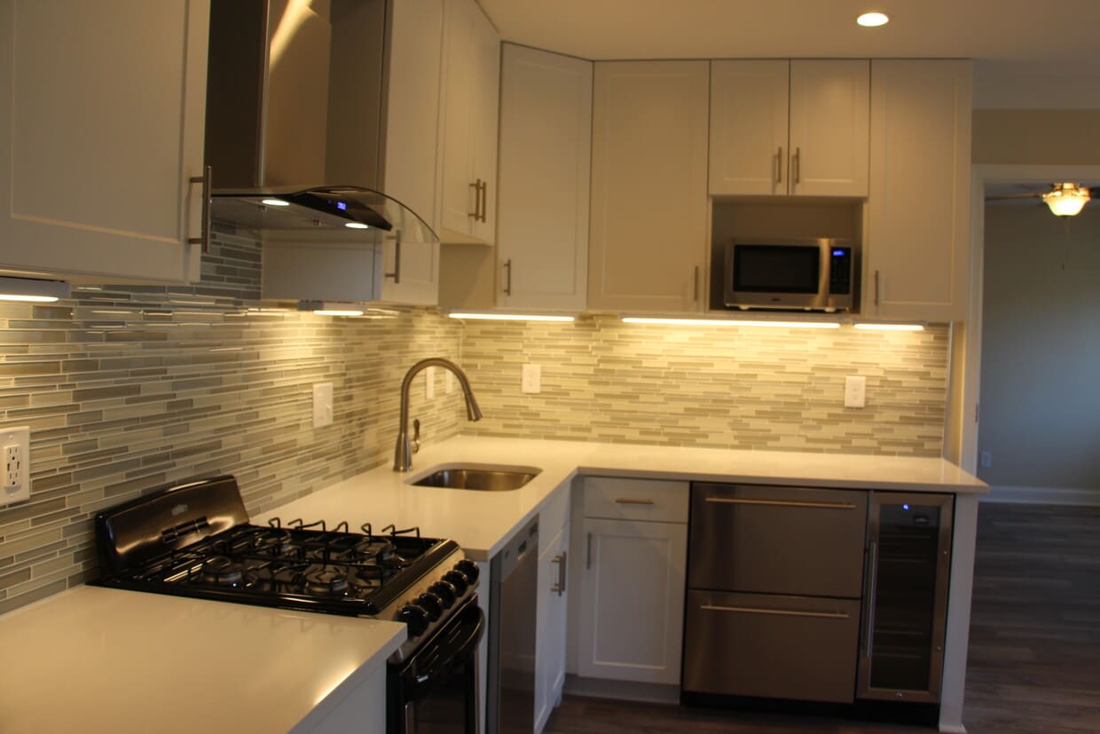

It is time for something new – a new way to live, a new space to connect, and a new place to call home. This boutique building of only 11 units is the perfect location for young professionals who want a quiet place to live but also want to be close to a vibrant urban area. Located in the heart of Clarendon only two blocks from Clarendon Metro station, this brand new building offers four distinctive spacious floor plans with gourmet kitchens, sleek finishes and designer amenities, custom built-ins, contemporary cabinets, new hard wood floors, washer/dry in unit, stylish finishes throughout and tons of natural light. Property features: • Fully equipped chef-inspired kitchens with designer appliances, cabinets, and counter tops • Modern, under-the-counter refrigerator and beverage coolers • Bright, open floor plans, thoughtfully crafted spaces • LG brand zone-controlled air conditioning/heating • Upscale bathroom with chic square vessel sinks and trendy tiling • Modern ceiling fans and recessed lighting throughout • Generously sized living room – perfect for working from home Building features include keyless entry system, fully wired fitness center, high-speed internet services, electric car charging station, and off-street parking. Sorry, no pets. When being at home is more important than ever, discover your new living and work-at-home- space. Please contact us for a virtual or in-person tour of this modern building that offers an extraordinary living experience.
9th Road Apartments is an apartment community located in Arlington County and the 22201 ZIP Code. This area is served by the Arlington County Public Schools attendance zone.
Air Conditioning
High Speed Internet Access
Hardwood Floors
Disposal
In many ways, Arlington’s Clarendon/Courthouse neighborhood leads a double life. On the one hand, the mix of upscale single-family homes and swanky apartments combined with the super-convenient access to Washington (just a mile away and served by multiple Metro stops) make this an ideal location for DC-area commuters seeking a more suburban home environment. The abundance of parks and playgrounds reflects the family-friendly nature of the community, and the local public schools are among the best in the region. Parts of the neighborhood also contain several corporate high-rises, giving many folks the option of walking to work.
However, Clarendon/Courthouse also has a lively, fun side. The neighborhood is generally known as the nightlife capital of Arlington – the robust bar and club scene along Clarendon Avenue attracts partiers from across the DC area on weekends.
Learn more about living in Clarendon/Courthouse| Colleges & Universities | Distance | ||
|---|---|---|---|
| Colleges & Universities | Distance | ||
| Walk: | 9 min | 0.5 mi | |
| Drive: | 7 min | 3.1 mi | |
| Drive: | 9 min | 3.4 mi | |
| Drive: | 10 min | 4.3 mi |


Transportation options available in Arlington include Clarendon, located 0.3 mile from 9th Road Apartments. 9th Road Apartments is near Ronald Reagan Washington Ntl, located 4.9 miles or 12 minutes away, and Washington Dulles International, located 23.0 miles or 38 minutes away.
| Transit / Subway | Distance | ||
|---|---|---|---|
| Transit / Subway | Distance | ||
|
|
Walk: | 6 min | 0.3 mi |
|
|
Walk: | 10 min | 0.6 mi |
| Walk: | 15 min | 0.8 mi | |
|
|
Walk: | 19 min | 1.0 mi |
|
|
Drive: | 5 min | 2.2 mi |
| Commuter Rail | Distance | ||
|---|---|---|---|
| Commuter Rail | Distance | ||
|
|
Drive: | 8 min | 3.6 mi |
|
|
Drive: | 10 min | 4.7 mi |
|
|
Drive: | 10 min | 4.7 mi |
|
|
Drive: | 11 min | 5.8 mi |
|
|
Drive: | 12 min | 6.0 mi |
| Airports | Distance | ||
|---|---|---|---|
| Airports | Distance | ||
|
Ronald Reagan Washington Ntl
|
Drive: | 12 min | 4.9 mi |
|
Washington Dulles International
|
Drive: | 38 min | 23.0 mi |
Time and distance from 9th Road Apartments.
| Shopping Centers | Distance | ||
|---|---|---|---|
| Shopping Centers | Distance | ||
| Walk: | 8 min | 0.4 mi | |
| Walk: | 10 min | 0.5 mi | |
| Walk: | 19 min | 1.0 mi |
| Parks and Recreation | Distance | ||
|---|---|---|---|
| Parks and Recreation | Distance | ||
|
David M. Brown Planetarium
|
Drive: | 3 min | 1.1 mi |
|
Cherry Valley Park
|
Drive: | 3 min | 1.3 mi |
|
Fort C.F. Smith Park & Historic Site
|
Drive: | 4 min | 1.7 mi |
|
Fort Bennett Park and Palisades Trail
|
Drive: | 4 min | 1.7 mi |
|
Ballston Beaver Pond Park
|
Drive: | 11 min | 5.8 mi |
| Hospitals | Distance | ||
|---|---|---|---|
| Hospitals | Distance | ||
| Drive: | 5 min | 1.8 mi | |
| Drive: | 5 min | 2.2 mi | |
| Drive: | 9 min | 3.6 mi |
| Military Bases | Distance | ||
|---|---|---|---|
| Military Bases | Distance | ||
| Drive: | 5 min | 1.9 mi |
What Are Walk Score®, Transit Score®, and Bike Score® Ratings?
Walk Score® measures the walkability of any address. Transit Score® measures access to public transit. Bike Score® measures the bikeability of any address.
What is a Sound Score Rating?
A Sound Score Rating aggregates noise caused by vehicle traffic, airplane traffic and local sources

3100 9th Rd N
Arlington, VA 22201


