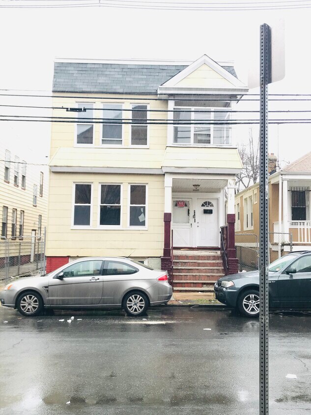
97 Aldine St
97 Aldine St,
Newark,
NJ
07112
2 Weeks Ago
Favorites
97 Aldine St

Favorites
Check Back Soon for Upcoming Availability
Fees and Policies
The fees below are based on community-supplied data and may exclude additional fees and utilities.
- Dogs Allowed
-
Fees not specified
- Cats Allowed
-
Fees not specified
Details
Lease Options
-
12 Months
About 97 Aldine St Newark, NJ 07112
Large 4 Bedroom Apartment 1st Floor Apt Fully Renovated Large Master Bedroom Spacious Kitchen -- New -- Eat in Kitchen Large Living Room Updated Bathroom Hardwood Flooring 1st Floor Apt Available Immediately Call SAM to view and for the requirements
97 Aldine St is an apartment community located in Essex County and the 07112 ZIP Code.
Apartment Features
- Kitchen
- Hardwood Floors
- Sunroom
Location
Get Directions
Located in the South Ward section of Newark, New Jersey, the neighborhood of Weequahic houses a small suburban residential area along with several parks, medical centers, and a number of commercial businesses. On the eastern border of the town stands Weequahic Park, a beautiful natural reserve that remains the centerpiece of the neighborhood and one of Newark's largest parks. There’s a well-maintained jogging path to enjoy and Weequahic Golf Course, the oldest public golf course in the US.
Weequahic is roughly 3.5 miles from the Newark city center, next to other suburban communities such as Hillside, Irvington, and Elizabeth. The neighborhood also benefits from its close proximity to Newark Liberty International Airport, one of the busiest airports in the area.
This is an active area of New Jersey, and the landscape around Weequahic has plenty to offer in terms of dining and retail. Another plus? New York City is just 40 minutes away.
Learn more about living in WeequahicBelow are rent ranges for similar nearby apartments
Amenities
- Kitchen
- Hardwood Floors
- Sunroom
Education
| Colleges & Universities | Distance | ||
|---|---|---|---|
| Colleges & Universities | Distance | ||
| Drive: | 7 min | 3.8 mi | |
| Drive: | 8 min | 3.9 mi | |
| Drive: | 8 min | 3.9 mi | |
| Drive: | 10 min | 4.2 mi |
97 Aldine St is within 8 minutes or 3.9 miles from Kean University. It is also near Essex County College and N.J. Inst. of Technology.
Transportation options available in Newark include Norfolk Street Light Rail Station, located 3.7 miles from 97 Aldine St. 97 Aldine St is near Newark Liberty International, located 5.5 miles or 8 minutes away, and LaGuardia, located 24.8 miles or 42 minutes away.
| Transit / Subway | Distance | ||
|---|---|---|---|
| Transit / Subway | Distance | ||
| Drive: | 7 min | 3.7 mi | |
| Drive: | 7 min | 3.8 mi | |
| Drive: | 7 min | 3.8 mi | |
| Drive: | 8 min | 4.0 mi | |
| Drive: | 8 min | 4.0 mi |
| Commuter Rail | Distance | ||
|---|---|---|---|
| Commuter Rail | Distance | ||
| Drive: | 8 min | 2.8 mi | |
| Drive: | 9 min | 3.1 mi | |
|
|
Drive: | 9 min | 3.1 mi |
| Drive: | 6 min | 3.2 mi | |
|
|
Drive: | 10 min | 3.9 mi |
| Airports | Distance | ||
|---|---|---|---|
| Airports | Distance | ||
|
Newark Liberty International
|
Drive: | 8 min | 5.5 mi |
|
LaGuardia
|
Drive: | 42 min | 24.8 mi |
Time and distance from 97 Aldine St.
| Shopping Centers | Distance | ||
|---|---|---|---|
| Shopping Centers | Distance | ||
| Walk: | 11 min | 0.6 mi | |
| Drive: | 3 min | 1.6 mi | |
| Drive: | 4 min | 1.8 mi |
97 Aldine St has 3 shopping centers within 1.8 miles, which is about a 4-minute walk. The miles and minutes will be for the farthest away property.
| Parks and Recreation | Distance | ||
|---|---|---|---|
| Parks and Recreation | Distance | ||
|
Newark Museum and Dreyfuss Planetarium
|
Drive: | 8 min | 4.1 mi |
|
Branch Brook Park
|
Drive: | 12 min | 5.6 mi |
|
Greenwood Gardens
|
Drive: | 14 min | 7.3 mi |
|
Edison National Historic Site
|
Drive: | 14 min | 7.6 mi |
|
Turtle Back Zoo
|
Drive: | 17 min | 9.3 mi |
97 Aldine St has 5 parks within 9.3 miles, including Newark Museum and Dreyfuss Planetarium, Branch Brook Park, and Edison National Historic Site.
| Hospitals | Distance | ||
|---|---|---|---|
| Hospitals | Distance | ||
| Walk: | 5 min | 0.3 mi | |
| Drive: | 6 min | 3.1 mi | |
| Drive: | 7 min | 3.8 mi |
97 Aldine St has 3 hospitals within 3.8 miles, the nearest is Newark Beth Israel Medical Center which is 0.3 mile away and a 5 minute walk.
| Military Bases | Distance | ||
|---|---|---|---|
| Military Bases | Distance | ||
| Drive: | 13 min | 9.4 mi | |
| Drive: | 22 min | 12.2 mi | |
| Drive: | 30 min | 15.0 mi |
97 Aldine St has 3 military bases within 15.0 miles, the nearest is Military Ocean Terminal which is 9.4 miles away and a 13 minute drive.
You May Also Like
Similar Rentals Nearby


What Are Walk Score®, Transit Score®, and Bike Score® Ratings?
Walk Score® measures the walkability of any address. Transit Score® measures access to public transit. Bike Score® measures the bikeability of any address.
What is a Sound Score Rating?
A Sound Score Rating aggregates noise caused by vehicle traffic, airplane traffic and local sources