
-
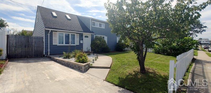
Single Family Home at 93 Poplar St , Carteret
$2,200
/ Month
93 Poplar St
Carteret, NJ 07008
2 Weeks Ago
Favorites
93 Poplar St

Favorites
Check Back Soon for Upcoming Availability
| Beds | Baths | Average SF |
|---|---|---|
| 4 Bedrooms 4 Bedrooms 4 Br | 2 Baths 2 Baths 2 Ba | — |
Fees and Policies
Details
Utilities Included
-
Gas
-
Water
-
Electricity
-
Heat
-
Trash Removal
-
Sewer
-
Air Conditioning
About This Property
Absolutely Stunning Property Situated in A Quiet Street. Many Custom Features Including Master Bedroom Suite Conveniently Located on The First Floor with Full Bath & Walk in Closet, The Beautiful Kitchen Offers Stainless Steel Appliances and Granite Countertops & Formal Dining Room. Private & Beautiful Backyard Deck. Other Features Include Central AC, Forced Hot Air, Laundry Room Main Level and Much More!! See It Today!!!
93 Poplar St is a house located in Middlesex County and the 07008 ZIP Code. This area is served by the Carteret Public attendance zone.
House Features
Washer/Dryer
Air Conditioning
Dishwasher
Washer/Dryer Hookup
- Washer/Dryer
- Washer/Dryer Hookup
- Air Conditioning
- Fireplace
- Dishwasher
- Disposal
- Granite Countertops
- Stainless Steel Appliances
- Hardwood Floors
- Dining Room
- Walk-In Closets
- Storage Space
Location
Get Directions
Located directly across the Arthur Kill from Staten Island, Carteret was once part of the Woodbridge Township. It became the borough of Roosevelt in 1906 and was renamed Carteret in 1922. This popular community is bordered by the Rahway River to the north, Arthur Kill to the east, and the Ernest L. Oros Wildlife Preserve to the west. Due to its central location, the borough bills itself as the "Center of it All."
Residents enjoy a fantastic location and beautiful parks. Carteret Waterfront Park has a fishing pier and access to two hiking trails: Danielle's Garden Trail and the Waterfront Fitness Trail. Shopping in Carteret is plentiful -- the brick-paved sidewalks and outdoor cafes along Washington Avenue provide historic charm and locally-owned businesses, while the shops and restaurants along Roosevelt Avenue have a more modern feel. With just 22 miles to Manhattan, 10 miles to Newark, and 70 miles to Philadelphia, residents can easily commute to nearby cities.
Learn more about living in Carteret
Amenities
- Washer/Dryer
- Washer/Dryer Hookup
- Air Conditioning
- Fireplace
- Dishwasher
- Disposal
- Granite Countertops
- Stainless Steel Appliances
- Hardwood Floors
- Dining Room
- Walk-In Closets
- Storage Space
Expenses
Utilities Included
Gas, Water, Electricity, Heat, Trash Removal, Sewer, Air Conditioning
Included
Education
| Colleges & Universities | Distance | ||
|---|---|---|---|
| Colleges & Universities | Distance | ||
| Drive: | 16 min | 7.8 mi | |
| Drive: | 19 min | 9.4 mi | |
| Drive: | 20 min | 10.7 mi | |
| Drive: | 26 min | 11.2 mi |
93 Poplar St is within 16 minutes or 7.8 miles from Union County Coll., Elizabeth. It is also near Kean University and Union County College, Cranford.
Schools


Public Elementary School
Grades K-5
361 Students
Nearby
Public Elementary School
Grades 5-6
553 Students
Nearby
Public High School
Grades 9-12
1,089 Students
Attendance Zone
Private Elementary, Middle & High School
40 Students
Nearby
Private Elementary School
Grades PK-5
Nearby
School data provided by
 The GreatSchools Rating helps parents compare schools within a state based on a variety of school quality indicators and provides a helpful picture of how effectively each school serves all of its students. Ratings are on a scale of 1 (below average) to 10 (above average) and can include test scores, college readiness, academic progress, advanced courses, equity, discipline and attendance data. We also advise parents to visit schools, consider other information on school performance and programs, and consider family needs as part of the school selection process.
View GreatSchools Rating Methodology
Data provided by GreatSchools.org © 2025. All rights reserved.
View GreatSchools Rating Methodology
Data provided by GreatSchools.org © 2025. All rights reserved.
Transportation options available in Carteret include 8Th Street Light Rail Station, located 12.3 miles from 93 Poplar St. 93 Poplar St is near Newark Liberty International, located 13.9 miles or 24 minutes away, and LaGuardia, located 31.2 miles or 53 minutes away.
| Transit / Subway | Distance | ||
|---|---|---|---|
| Transit / Subway | Distance | ||
| Drive: | 22 min | 12.3 mi | |
|
|
Drive: | 24 min | 13.5 mi |
|
|
Drive: | 23 min | 15.1 mi |
|
|
Drive: | 22 min | 15.2 mi |
| Commuter Rail | Distance | ||
|---|---|---|---|
| Commuter Rail | Distance | ||
|
|
Drive: | 7 min | 3.1 mi |
|
|
Drive: | 11 min | 4.4 mi |
|
|
Drive: | 11 min | 4.8 mi |
|
|
Drive: | 14 min | 7.1 mi |
|
|
Drive: | 20 min | 9.6 mi |
| Airports | Distance | ||
|---|---|---|---|
| Airports | Distance | ||
|
Newark Liberty International
|
Drive: | 24 min | 13.9 mi |
|
LaGuardia
|
Drive: | 53 min | 31.2 mi |
Time and distance from 93 Poplar St.
| Shopping Centers | Distance | ||
|---|---|---|---|
| Shopping Centers | Distance | ||
| Drive: | 4 min | 1.4 mi | |
| Drive: | 5 min | 1.6 mi | |
| Drive: | 5 min | 1.8 mi |
93 Poplar St has 3 shopping centers within 1.8 miles, which is about a 5-minute drive. The miles and minutes will be for the farthest away property.
| Parks and Recreation | Distance | ||
|---|---|---|---|
| Parks and Recreation | Distance | ||
|
Liberty State Park
|
Drive: | 7 min | 2.4 mi |
|
Hawk Rise Sanctuary
|
Drive: | 13 min | 5.7 mi |
|
Bloomingdale Park
|
Drive: | 18 min | 8.6 mi |
|
Clay Pit Ponds State Park Preserve
|
Drive: | 20 min | 9.1 mi |
|
Freshkills Park
|
Drive: | 23 min | 12.0 mi |
93 Poplar St has 5 parks within 12.0 miles, including Liberty State Park, Hawk Rise Sanctuary, and Bloomingdale Park.
| Hospitals | Distance | ||
|---|---|---|---|
| Hospitals | Distance | ||
| Drive: | 14 min | 5.7 mi | |
| Drive: | 13 min | 6.1 mi | |
| Drive: | 17 min | 7.9 mi |
93 Poplar St has 3 hospitals within 7.9 miles, the nearest is Robert Wood Johnson University Hospital at Rahway which is 5.7 miles away and a 14 minute drive.
| Military Bases | Distance | ||
|---|---|---|---|
| Military Bases | Distance | ||
| Drive: | 21 min | 8.7 mi | |
| Drive: | 24 min | 9.5 mi | |
| Drive: | 29 min | 15.2 mi |
93 Poplar St has 3 military bases within 15.2 miles, the nearest is Ash Brook Reservation which is 8.7 miles away and a 21 minute drive.
You May Also Like
Similar Rentals Nearby
-
-

-

-

-

-

-
 $3,8004 Beds, 2.5 Baths, 2,130 sq ftHouse for Rent
 -

-

-

What Are Walk Score®, Transit Score®, and Bike Score® Ratings?
Walk Score® measures the walkability of any address. Transit Score® measures access to public transit. Bike Score® measures the bikeability of any address.
What is a Sound Score Rating?
A Sound Score Rating aggregates noise caused by vehicle traffic, airplane traffic and local sources

93 Poplar St
Carteret, NJ 07008