


915 Broad
915 Broad St,
Newark,
NJ
07102
-
Monthly Rent
$1,810 - $2,000
-
Bedrooms
1 bd
-
Bathrooms
1 ba
-
Square Feet
647 - 729 sq ft
Highlights
- Walker's Paradise
- Premier Transit Location
- English and Spanish Speaking Staff
- Loft Layout
- Roof Terrace
- Walk-In Closets
- Deck
- Controlled Access
- Doorman
Pricing & Floor Plans
Check Back Soon for Upcoming Availability
| Beds | Baths | Average SF | Availability |
|---|---|---|---|
| 1 Bedroom 1 Bedroom 1 Br | 1 Bath 1 Bath 1 Ba | 663 SF | Call for Availability |
-
Unit 406price $2,000square feet 655availibility Call for Availability
-
Unit 516price $2,000square feet 655availibility Call for Availability
-
Unit 519price $2,000square feet 655availibility Call for Availability
Fees and Policies
The fees below are based on community-supplied data and may exclude additional fees and utilities.
-
Surface Lot
-
Parking FeeMax of 38. Charged per vehicle.$135 / mo
CommentsMax of 38, Parking only if available.Read More Read Less -
Property Fee Disclaimer: Based on community-supplied data and independent market research. Subject to change without notice. May exclude fees for mandatory or optional services and usage-based utilities.
Details
Utilities Included
-
Water
-
Trash Removal
Property Information
-
Built in 2020
-
84 units/5 stories
-
LEED certified Gold
Matterport 3D Tour
About 915 Broad
915 Broad Street is in the Newark Central Business District neighborhood and it's only an eight minute walk from Newark Penn Station.In order to ensure a healthier living environment and in keeping with our commitment to environmental sustainability, this building is LEED (Leadership in Energy and Environmental Design) certified Silver.The LEED designation refers to the fact that 915 Broad Street is designed and constructed to use less energy, reduce waste, minimize negative impacts on the environment, and support well-being. Enjoy an array of green living benefits including energy-efficient appliances, free bicycle parking, energy efficient double-pane glass windows,and much more.
915 Broad is an apartment community located in Essex County and the 07102 ZIP Code. This area is served by the The Newark Public attendance zone.
Unique Features
- Fitness Center Resident Lounge Roofdeck
- Fitness Center Resident Lounge Roof Deck
Contact
Community Amenities
Fitness Center
Laundry Facilities
Elevator
Doorman
- Package Service
- Laundry Facilities
- Controlled Access
- Maintenance on site
- Property Manager on Site
- Doorman
- Concierge
- Video Patrol
- On-Site Retail
- Recycling
- Key Fob Entry
- Elevator
- Lounge
- Multi Use Room
- Fitness Center
- Bicycle Storage
- Gated
- Fenced Lot
- Roof Terrace
Apartment Features
Washer/Dryer
Air Conditioning
Dishwasher
Washer/Dryer Hookup
Loft Layout
High Speed Internet Access
Hardwood Floors
Walk-In Closets
Indoor Features
- High Speed Internet Access
- Wi-Fi
- Washer/Dryer
- Washer/Dryer Hookup
- Air Conditioning
- Heating
- Smoke Free
- Cable Ready
- Trash Compactor
- Storage Space
- Double Vanities
- Tub/Shower
- Intercom
- Sprinkler System
- Wheelchair Accessible (Rooms)
Kitchen Features & Appliances
- Dishwasher
- Granite Countertops
- Stainless Steel Appliances
- Pantry
- Island Kitchen
- Eat-in Kitchen
- Kitchen
- Microwave
- Oven
- Range
- Refrigerator
- Freezer
- Instant Hot Water
Model Details
- Hardwood Floors
- Views
- Walk-In Closets
- Linen Closet
- Loft Layout
- Double Pane Windows
- Deck
- Package Service
- Laundry Facilities
- Controlled Access
- Maintenance on site
- Property Manager on Site
- Doorman
- Concierge
- Video Patrol
- On-Site Retail
- Recycling
- Key Fob Entry
- Elevator
- Lounge
- Multi Use Room
- Gated
- Fenced Lot
- Roof Terrace
- Fitness Center
- Bicycle Storage
- Fitness Center Resident Lounge Roofdeck
- Fitness Center Resident Lounge Roof Deck
- High Speed Internet Access
- Wi-Fi
- Washer/Dryer
- Washer/Dryer Hookup
- Air Conditioning
- Heating
- Smoke Free
- Cable Ready
- Trash Compactor
- Storage Space
- Double Vanities
- Tub/Shower
- Intercom
- Sprinkler System
- Wheelchair Accessible (Rooms)
- Dishwasher
- Granite Countertops
- Stainless Steel Appliances
- Pantry
- Island Kitchen
- Eat-in Kitchen
- Kitchen
- Microwave
- Oven
- Range
- Refrigerator
- Freezer
- Instant Hot Water
- Hardwood Floors
- Views
- Walk-In Closets
- Linen Closet
- Loft Layout
- Double Pane Windows
- Deck
| Monday | By Appointment |
|---|---|
| Tuesday | By Appointment |
| Wednesday | By Appointment |
| Thursday | By Appointment |
| Friday | By Appointment |
| Saturday | By Appointment |
| Sunday | By Appointment |
The largest city in New Jersey and the second biggest in the New York metro area, Newark has undergone an artistic and cultural renaissance in recent decades. A major international airport and shipping port, several institutions of higher learning, including two Rutgers campuses and the New Jersey Institute of Technology, and the headquarters of Prudential Financial, Panasonic, and PSEG all call Newark home, making it one of the busiest areas in the Garden State. With a melting pot of residents represented across the city's five distinct wards, Newark (which is Essex County's urban center) never fails to stimulate its residents with a diverse, urban landscape. Sitting just eight miles west of Manhattan, Newark allows its residents to easily commute to one of the world's most cosmopolitan destinations, which is just a short drive or train ride away.
Learn more about living in Downtown Newark| Colleges & Universities | Distance | ||
|---|---|---|---|
| Colleges & Universities | Distance | ||
| Walk: | 14 min | 0.8 mi | |
| Walk: | 17 min | 0.9 mi | |
| Walk: | 20 min | 1.1 mi | |
| Drive: | 10 min | 4.4 mi |


View GreatSchools Rating Methodology
Data provided by GreatSchools.org © 2025. All rights reserved.
Transportation options available in Newark include Military Park, located 0.4 mile from 915 Broad. 915 Broad is near Newark Liberty International, located 4.8 miles or 7 minutes away, and LaGuardia, located 24.1 miles or 42 minutes away.
| Transit / Subway | Distance | ||
|---|---|---|---|
| Transit / Subway | Distance | ||
|
|
Walk: | 8 min | 0.4 mi |
|
|
Walk: | 11 min | 0.6 mi |
|
|
Walk: | 17 min | 0.9 mi |
|
|
Drive: | 2 min | 1.1 mi |
|
|
Drive: | 2 min | 1.2 mi |
| Commuter Rail | Distance | ||
|---|---|---|---|
| Commuter Rail | Distance | ||
|
|
Walk: | 15 min | 0.8 mi |
|
|
Drive: | 4 min | 1.7 mi |
|
|
Drive: | 4 min | 2.1 mi |
|
|
Drive: | 7 min | 3.1 mi |
|
|
Drive: | 9 min | 4.1 mi |
| Airports | Distance | ||
|---|---|---|---|
| Airports | Distance | ||
|
Newark Liberty International
|
Drive: | 7 min | 4.8 mi |
|
LaGuardia
|
Drive: | 42 min | 24.1 mi |
Time and distance from 915 Broad.
| Shopping Centers | Distance | ||
|---|---|---|---|
| Shopping Centers | Distance | ||
| Walk: | 10 min | 0.6 mi | |
| Walk: | 18 min | 0.9 mi | |
| Drive: | 3 min | 1.3 mi |
| Parks and Recreation | Distance | ||
|---|---|---|---|
| Parks and Recreation | Distance | ||
|
Newark Museum and Dreyfuss Planetarium
|
Walk: | 16 min | 0.9 mi |
|
Branch Brook Park
|
Drive: | 6 min | 2.9 mi |
|
Kearny Marsh
|
Drive: | 9 min | 4.1 mi |
|
Richard W. DeKorte Park
|
Drive: | 13 min | 6.6 mi |
|
Stephen Gregg Park
|
Drive: | 13 min | 8.2 mi |
| Hospitals | Distance | ||
|---|---|---|---|
| Hospitals | Distance | ||
| Walk: | 19 min | 1.0 mi | |
| Drive: | 3 min | 1.4 mi | |
| Drive: | 5 min | 2.9 mi |
| Military Bases | Distance | ||
|---|---|---|---|
| Military Bases | Distance | ||
| Drive: | 13 min | 8.7 mi | |
| Drive: | 25 min | 16.3 mi | |
| Drive: | 28 min | 16.7 mi |
915 Broad Photos
-
915 Broad
-
1BR, 1BA - 578SF
-
City Hall View
-
-
-
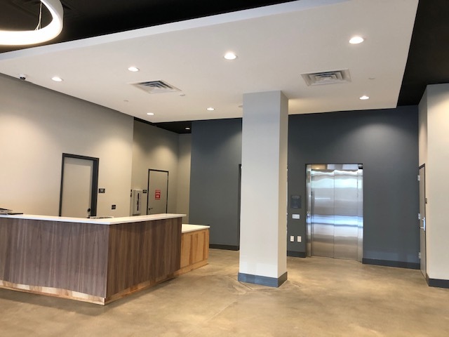
Building Lobby
-
City Hall View
-
Open Kitchen
-
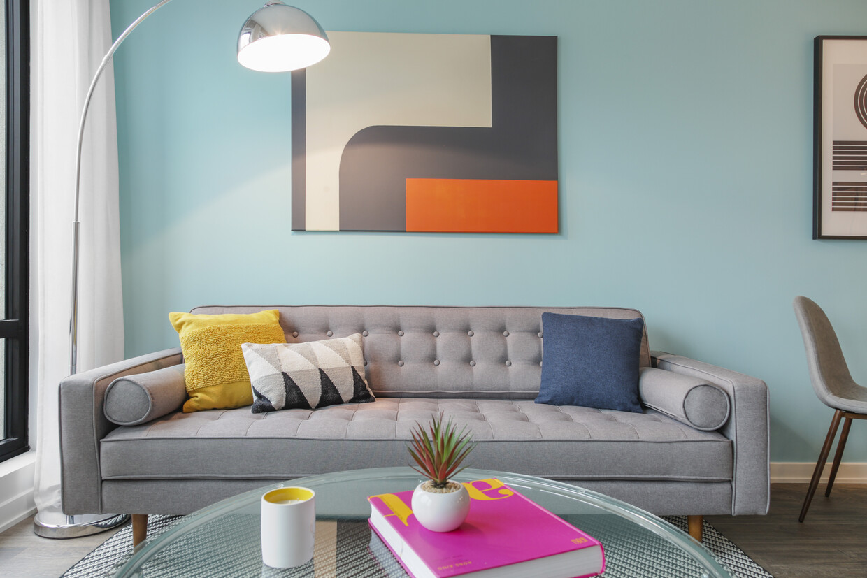
Living Room
Nearby Apartments
Within 50 Miles of 915 Broad
915 Broad has units with in‑unit washers and dryers, making laundry day simple for residents.
Select utilities are included in rent at 915 Broad, including water and trash removal. Residents are responsible for any other utilities not listed.
915 Broad does not allow pets, though service animals are always welcome in accordance with applicable laws.
A good rule of thumb is to spend no more than 30% of your gross income on rent. Based on the lowest available rent of $1,810 for a one-bedroom, you would need to earn about $65,000 per year to qualify. Want to double-check your budget? Try our Rent Affordability Calculator to see how much rent fits your income and lifestyle.
915 Broad is not currently offering any rent specials. Check back soon, as promotions change frequently.
Yes! 915 Broad offers 1 Matterport 3D Tours. Explore different floor plans and see unit level details, all without leaving home.
Statewide service is free, confidential, multilingual and always open. Three easy ways to reach Social Services in NJ: Dial 2-1-1; text your zip code to 898-211; or chat at https://www.nj211.org
What Are Walk Score®, Transit Score®, and Bike Score® Ratings?
Walk Score® measures the walkability of any address. Transit Score® measures access to public transit. Bike Score® measures the bikeability of any address.
What is a Sound Score Rating?
A Sound Score Rating aggregates noise caused by vehicle traffic, airplane traffic and local sources
915 Broad St
Newark, NJ 07102