
$2,720
5 Beds, 2 Baths, 1,762 sq ft
Townhome for Rent

| Beds | Baths | Average SF |
|---|---|---|
| 4 Bedrooms 4 Bedrooms 4 Br | 2 Baths 2 Baths 2 Ba | 2,000 SF |
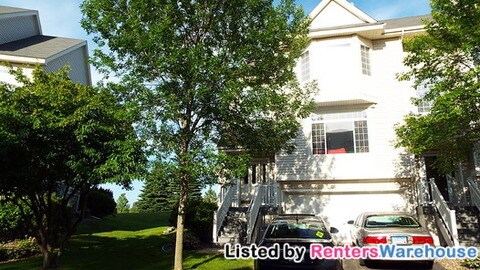
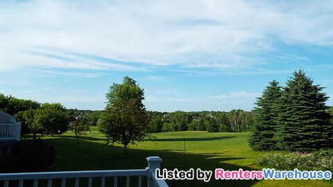
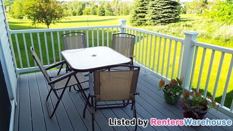
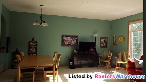
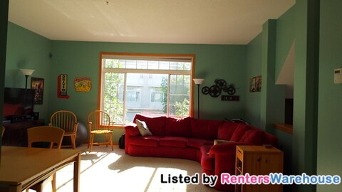
This townhome has a bright, spacious living room open to the kitchen and dining area with fireplace and half bath. Off the kitchen is a good sized deck has a perfect view of the golf course. Upstairs has the master bedroom with large walk in closet and private door to the full bathroom with jacuzzi tub, and 2 more bedrooms. Lower level has laundry, an additional bedroom and bathroom. Attached 2 car garage! Plenty of natural light and storage. Available Aug 1! Book a tour online with Amanda from Renters Warehouse today! Security deposit same as rent, app fee 45 per adult. No pets. HOA covers water, trash, lawn and snow care! Tenants responsible for Xcel, avg 245.
8828 Brunell Way is a townhome located in Dakota County and the 55076 ZIP Code. This area is served by the Inver Grove Heights Schools attendance zone.
Just off the eastern bank of the Mississippi River, Inver Grove Heights, Minnesota has all the natural beauty expected from the state known for its grassy rolling plains. South of the Twin Cities, Inver Grove Heights is a suburb of Saint Paul. This residential city provides easy access to the surrounding areas thanks to the highway that runs through the city, Highway 52.
Residents of this quiet town enjoy several events and volunteer opportunities that keeps people of Inver Grove Heights connected. There are also many local parks and a community center that provides the community with a variety of recreation opportunities and programs. The new development within the area makes Inver Grove a city with a pleasant mix of both old and new.
Learn more about living in Inver Grove Heights| Colleges & Universities | Distance | ||
|---|---|---|---|
| Colleges & Universities | Distance | ||
| Drive: | 4 min | 1.1 mi | |
| Drive: | 13 min | 8.4 mi | |
| Drive: | 17 min | 11.6 mi | |
| Drive: | 18 min | 12.1 mi |


Transportation options available in Inver Grove Heights include Fort Snelling Station, located 10.9 miles from 8828 Brunell Way. 8828 Brunell Way is near Minneapolis-St Paul International/Wold-Chamberlain, located 12.7 miles or 19 minutes away.
| Transit / Subway | Distance | ||
|---|---|---|---|
| Transit / Subway | Distance | ||
|
|
Drive: | 16 min | 10.9 mi |
| Drive: | 16 min | 10.9 mi | |
| Drive: | 16 min | 11.0 mi | |
| Drive: | 16 min | 11.2 mi | |
|
|
Drive: | 17 min | 11.7 mi |
| Commuter Rail | Distance | ||
|---|---|---|---|
| Commuter Rail | Distance | ||
|
|
Drive: | 16 min | 11.2 mi |
|
|
Drive: | 32 min | 18.1 mi |
|
|
Drive: | 37 min | 27.7 mi |
|
|
Drive: | 47 min | 35.8 mi |
|
|
Drive: | 51 min | 37.8 mi |
| Airports | Distance | ||
|---|---|---|---|
| Airports | Distance | ||
|
Minneapolis-St Paul International/Wold-Chamberlain
|
Drive: | 19 min | 12.7 mi |
Time and distance from 8828 Brunell Way.
| Shopping Centers | Distance | ||
|---|---|---|---|
| Shopping Centers | Distance | ||
| Walk: | 7 min | 0.4 mi | |
| Walk: | 9 min | 0.5 mi | |
| Drive: | 4 min | 1.3 mi |
| Parks and Recreation | Distance | ||
|---|---|---|---|
| Parks and Recreation | Distance | ||
|
Spring Lake Reserve
|
Drive: | 14 min | 8.1 mi |
|
Dodge Nature Center
|
Drive: | 13 min | 8.2 mi |
|
Crosby Farm Regional Park
|
Drive: | 16 min | 11.1 mi |
|
Cherokee Regional Park
|
Drive: | 18 min | 11.1 mi |
|
Fort Snelling State Park
|
Drive: | 21 min | 13.0 mi |
| Hospitals | Distance | ||
|---|---|---|---|
| Hospitals | Distance | ||
| Drive: | 17 min | 11.5 mi | |
| Drive: | 17 min | 11.8 mi | |
| Drive: | 18 min | 11.9 mi |
| Military Bases | Distance | ||
|---|---|---|---|
| Military Bases | Distance | ||
| Drive: | 17 min | 11.5 mi |


What Are Walk Score®, Transit Score®, and Bike Score® Ratings?
Walk Score® measures the walkability of any address. Transit Score® measures access to public transit. Bike Score® measures the bikeability of any address.
What is a Sound Score Rating?
A Sound Score Rating aggregates noise caused by vehicle traffic, airplane traffic and local sources

8828 Brunell Way
Inver Grove Heights, MN 55076


