
$2,800
/ Month
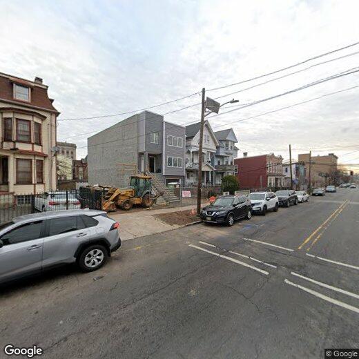
85 3rd Ave
Newark, NJ 07104
Today
|
Edit
Favorites
201-939-0050
-
Bedrooms
3
-
Bathrooms
2
-
Square Feet
--
-
Available
Available Now
Highlights
- Wood Flooring
- Shades
- Eat-In Kitchen
- Walk-In Closet
- Bathtub with Shower
- Forced Air Heating and Cooling System
85 3rd Ave

Favorites
85 3rd Ave is a townhome located in Essex County and the 07104 ZIP Code. This area is served by the The Newark Public attendance zone.
* Price shown is base rent. Excludes user-selected optional fees and variable or usage-based fees and required charges due at or prior to move-in or at move-out. Price, availability, fees, and any applicable rent special are subject to change without notice.
* Square footage definitions vary. Displayed square footage is approximate.
Home Details
Home Type
Duplex
Year Built
Built in 2025
Bedrooms and Bathrooms
Walk-In Closet
Bathtub with Shower
Dressing Area
2 Full Bathrooms
3 Bedrooms
Home Design
Tile
Home Security
Carbon Monoxide Detectors
Fire and Smoke Detector
Interior Spaces
Wood Flooring
Shades
Kitchen
Eat-In Kitchen
Breakfast Bar
Gas Oven or Range
Microwave
Dishwasher
Laundry
Dryer
Laundry in unit
Washer
Listing and Financial Details
Assessor Parcel Number 1614-00561-0000-00036-0002-
Tenant pays for electric, gas, heat
Lot Details
3,049 Sq Ft Lot
Level Lot
Parking
Assigned Parking
1 Parking Space
Utilities
Forced Air Heating and Cooling System
Gas Water Heater
Two Cooling Systems Mounted To A Wall/Window
Community Details
Pet Policy
Call for details about the types of pets allowed
Contact
- Listed by SANDRA OLIVEIRA | GardenStateMLS#NJ
- Phone Number
- Contact
-
Source
Garden State Multiple Listing Service, LLC
Copyright © 2025 Garden State MLS, LLC. All rights reserved. All information provided by the listing agent/broker is deemed reliable but is not guaranteed and should be independently verified.
Location
Get Directions
Amenities
- Tile Floors
- Grill
Framed on the right by the Passaic River is the suburban neighborhood of Mount Pleasant-Lower Broadway. This community is ideal for commuters as it provides easy access to Interstate 280 and Highway 21, and it is situated just miles north of Downtown Newark. The suburb’s primarily residential streets are home to historic places of worship. Admire the impressive architecture of the community’s long-standing churches, including Saint Lucy's Church and the Archdiocese of Newark. Next, visit the city’s longest operating synagogue, the stunning Jewish Museum of New Jersey.
Moments away in Newark, renters in the Mount Pleasant-Lower Broadway area can enjoy exciting attractions including historic house museums, scenic parks, and a planetarium. To the west of the suburb is Branch Brook Park. Although good for recreation and fresh air year-round, this park really comes to life during the Cherry Blossom Festival.
Learn more about living in Mount Pleasant-Lower Broad
Education
| Colleges & Universities | Distance | ||
|---|---|---|---|
| Colleges & Universities | Distance | ||
| Drive: | 2 min | 1.3 mi | |
| Drive: | 3 min | 1.7 mi | |
| Drive: | 4 min | 1.8 mi | |
| Drive: | 6 min | 3.3 mi |
85 3rd Ave is within 2 minutes or 1.3 miles from Rutgers, Newark Campus. It is also near N.J. Inst. of Technology and Essex County College.
Schools


Public Elementary & Middle School
Grades PK-8
516 Students
Nearby
Public Elementary & Middle School
Grades PK-8
753 Students
Attendance Zone
Public High School
Grades 9-12
1,734 Students
Attendance Zone
Public High School
Grades 9-12
665 Students
Attendance Zone
Private Elementary & Middle School
Grades K-8
288 Students
Nearby
School data provided by
 The GreatSchools Rating helps parents compare schools within a state based on a variety of school quality indicators and provides a helpful picture of how effectively each school serves all of its students. Ratings are on a scale of 1 (below average) to 10 (above average) and can include test scores, college readiness, academic progress, advanced courses, equity, discipline and attendance data. We also advise parents to visit schools, consider other information on school performance and programs, and consider family needs as part of the school selection process.
View GreatSchools Rating Methodology
Data provided by GreatSchools.org © 2025. All rights reserved.
View GreatSchools Rating Methodology
Data provided by GreatSchools.org © 2025. All rights reserved.
Transportation options available in Newark include Bloomfield Avenue, located 0.9 mile from 85 3rd Ave. 85 3rd Ave is near Newark Liberty International, located 7.1 miles or 11 minutes away, and LaGuardia, located 27.3 miles or 41 minutes away.
| Transit / Subway | Distance | ||
|---|---|---|---|
| Transit / Subway | Distance | ||
|
|
Walk: | 16 min | 0.9 mi |
|
|
Walk: | 19 min | 1.0 mi |
|
|
Drive: | 2 min | 1.3 mi |
|
|
Drive: | 3 min | 1.5 mi |
|
|
Drive: | 3 min | 1.6 mi |
| Commuter Rail | Distance | ||
|---|---|---|---|
| Commuter Rail | Distance | ||
|
|
Drive: | 3 min | 1.6 mi |
|
|
Drive: | 4 min | 2.1 mi |
|
|
Drive: | 4 min | 2.2 mi |
|
|
Drive: | 5 min | 2.6 mi |
|
|
Drive: | 5 min | 2.9 mi |
| Airports | Distance | ||
|---|---|---|---|
| Airports | Distance | ||
|
Newark Liberty International
|
Drive: | 11 min | 7.1 mi |
|
LaGuardia
|
Drive: | 41 min | 27.3 mi |
Time and distance from 85 3rd Ave.
| Shopping Centers | Distance | ||
|---|---|---|---|
| Shopping Centers | Distance | ||
| Walk: | 6 min | 0.3 mi | |
| Drive: | 2 min | 1.3 mi | |
| Drive: | 4 min | 1.6 mi |
85 3rd Ave has 3 shopping centers within 1.6 miles, which is about a 4-minute drive. The miles and minutes will be for the farthest away property.
| Parks and Recreation | Distance | ||
|---|---|---|---|
| Parks and Recreation | Distance | ||
|
Branch Brook Park
|
Drive: | 3 min | 1.1 mi |
|
Newark Museum and Dreyfuss Planetarium
|
Drive: | 2 min | 1.4 mi |
|
Kearny Marsh
|
Drive: | 8 min | 3.9 mi |
|
Richard W. DeKorte Park
|
Drive: | 10 min | 4.8 mi |
|
Meadowlands Environment Center
|
Drive: | 18 min | 7.6 mi |
85 3rd Ave has 5 parks within 7.6 miles, including Branch Brook Park, Newark Museum and Dreyfuss Planetarium, and Kearny Marsh.
| Hospitals | Distance | ||
|---|---|---|---|
| Hospitals | Distance | ||
| Drive: | 2 min | 1.3 mi | |
| Drive: | 4 min | 2.2 mi | |
| Drive: | 6 min | 3.1 mi |
85 3rd Ave has 3 hospitals within 3.1 miles, the nearest is Saint Michael's Medical Center which is 1.3 miles away and a 2 minute drive.
| Military Bases | Distance | ||
|---|---|---|---|
| Military Bases | Distance | ||
| Drive: | 17 min | 10.9 mi | |
| Drive: | 27 min | 13.0 mi | |
| Drive: | 32 min | 19.0 mi |
85 3rd Ave has 3 military bases within 19.0 miles, the nearest is Military Ocean Terminal which is 10.9 miles away and a 17 minute drive.
You May Also Like
How do I access Social Services in New Jersey?
Statewide service is free, confidential, multilingual and always open. Three easy ways to reach Social Services in NJ: Dial 2-1-1; text your zip code to 898-211; or chat at https://www.nj211.org
Similar Rentals Nearby


What Are Walk Score®, Transit Score®, and Bike Score® Ratings?
Walk Score® measures the walkability of any address. Transit Score® measures access to public transit. Bike Score® measures the bikeability of any address.
What is a Sound Score Rating?
A Sound Score Rating aggregates noise caused by vehicle traffic, airplane traffic and local sources

85 3rd Ave
Newark, NJ 07104