

$4,200 / Month
84 Beal Rd
Waltham, MA 02453
2 Weeks Ago
Favorites
84 Beal Rd

Favorites
Check Back Soon for Upcoming Availability
| Beds | Baths | Average SF |
|---|---|---|
| 3 Bedrooms 3 Bedrooms 3 Br | 2 Baths 2 Baths 2 Ba | 1,750 SF |
Fees and Policies
The fees below are based on community-supplied data and may exclude additional fees and utilities.
Pet policies are negotiable.
Details
Utilities Included
-
Trash Removal
About This Property
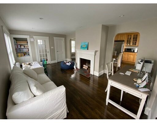
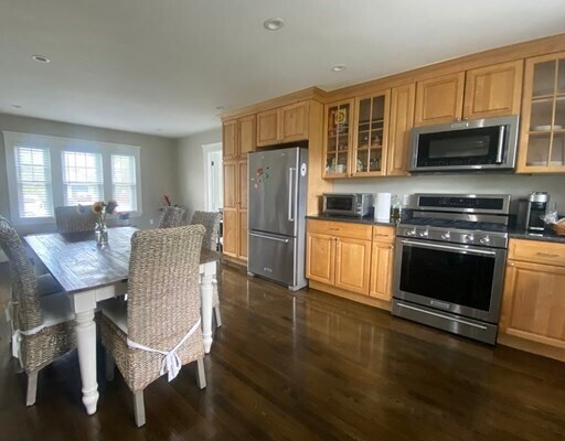
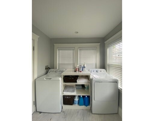
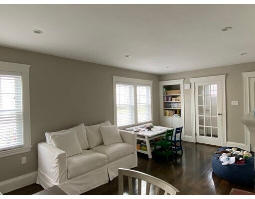
Meticulously Renovated 3BR/2BA Colonial in Desirable WARRENDALE Neighborhood. Come home to your Fireplaced Living Room that leads to an oversized Renovated Kitchen/Dining Room and a Full Bath with Laundry. Upstairs, find 3 Bedrooms and a Second Full Bath. Off of the kitchen, access both your Private Fenced-In Yard and Bonus Living Space in the Basement. Parking for two cars. Walk to Fitzgerald School and public transportation. Available for 7/1 move in.
84 Beal Rd is a house located in Middlesex County and the 02453 ZIP Code. This area is served by the Waltham attendance zone.
House Features
Dishwasher
Microwave
Refrigerator
Disposal
- Fireplace
- Dishwasher
- Disposal
- Microwave
- Range
- Refrigerator
- Walking/Biking Trails
- Fenced Lot
- Deck
Location
Get Directions
As its name implies, the Bentley College neighborhood surrounds Bentley University. The University of Massachusetts College of Agriculture is also located in the neighborhood. The presence of two college campuses fives the area an energetic feel. Bentley College is dominated by Bentley University and several large greenspaces, give the area a park-like feel. The residential areas in Bentley College consist of houses, townhomes, apartments, and condos. There are rentals available for every budget, but there are several housing options that are cheaper compared to other Waltham neighborhoods. Bentley College is about a mile from Main Street, which is home to Waltham’s downtown district. This charming thoroughfare is filled with restaurants, grocers, and shops. With Downtown Boston just 10 miles away, Bentley College attracts commuters looking for the ideal apartment just outside of Boston.
Learn more about living in Bentley CollegeBelow are rent ranges for similar nearby apartments
Amenities
- Fireplace
- Dishwasher
- Disposal
- Microwave
- Range
- Refrigerator
- Fenced Lot
- Deck
- Walking/Biking Trails
Expenses
Utilities Included
Trash Removal
Included
Education
| Colleges & Universities | Distance | ||
|---|---|---|---|
| Colleges & Universities | Distance | ||
| Drive: | 4 min | 1.6 mi | |
| Drive: | 8 min | 3.5 mi | |
| Drive: | 13 min | 4.9 mi | |
| Drive: | 12 min | 5.7 mi |
84 Beal Rd is within 4 minutes or 1.6 miles from Bentley University. It is also near Brandeis University and Boston College, Brighton.
Schools


Public Elementary School
Grades K-5
326 Students
Nearby
Public Elementary School
Grades K-5
378 Students
Attendance Zone
Public Middle School
Grades 6-8
595 Students
Attendance Zone
Public High School
Grades 9-12
1,751 Students
Attendance Zone
Private Elementary School
Grades PK-1
Nearby
Private Elementary & Middle School
Grades PK-8
115 Students
Nearby
Private High School
Grades 9-12
28 Students
Nearby
School data provided by
 The GreatSchools Rating helps parents compare schools within a state based on a variety of school quality indicators and provides a helpful picture of how effectively each school serves all of its students. Ratings are on a scale of 1 (below average) to 10 (above average) and can include test scores, college readiness, academic progress, advanced courses, equity, discipline and attendance data. We also advise parents to visit schools, consider other information on school performance and programs, and consider family needs as part of the school selection process.
View GreatSchools Rating Methodology
Data provided by GreatSchools.org © 2025. All rights reserved.
View GreatSchools Rating Methodology
Data provided by GreatSchools.org © 2025. All rights reserved.
Transportation options available in Waltham include Woodland Station, located 4.1 miles from 84 Beal Rd. 84 Beal Rd is near General Edward Lawrence Logan International, located 13.3 miles or 24 minutes away, and Worcester Regional, located 42.3 miles or 61 minutes away.
| Transit / Subway | Distance | ||
|---|---|---|---|
| Transit / Subway | Distance | ||
|
|
Drive: | 10 min | 4.1 mi |
|
|
Drive: | 10 min | 4.6 mi |
|
|
Drive: | 10 min | 4.6 mi |
|
|
Drive: | 10 min | 4.8 mi |
|
|
Drive: | 11 min | 5.5 mi |
| Commuter Rail | Distance | ||
|---|---|---|---|
| Commuter Rail | Distance | ||
|
|
Drive: | 4 min | 1.5 mi |
|
|
Drive: | 3 min | 1.7 mi |
| Drive: | 4 min | 1.8 mi | |
|
|
Drive: | 5 min | 2.6 mi |
|
|
Drive: | 7 min | 3.5 mi |
| Airports | Distance | ||
|---|---|---|---|
| Airports | Distance | ||
|
General Edward Lawrence Logan International
|
Drive: | 24 min | 13.3 mi |
|
Worcester Regional
|
Drive: | 61 min | 42.3 mi |
Time and distance from 84 Beal Rd.
| Shopping Centers | Distance | ||
|---|---|---|---|
| Shopping Centers | Distance | ||
| Walk: | 17 min | 0.9 mi | |
| Walk: | 19 min | 1.0 mi | |
| Drive: | 3 min | 1.1 mi |
84 Beal Rd has 3 shopping centers within 1.1 miles, which is about a 3-minute walk. The miles and minutes will be for the farthest away property.
| Parks and Recreation | Distance | ||
|---|---|---|---|
| Parks and Recreation | Distance | ||
|
Beaver Brook Reservation
|
Drive: | 4 min | 1.7 mi |
|
Mass Audubon's Habitat Education Center and Wildlife Sanctuary
|
Drive: | 8 min | 3.5 mi |
|
Harvard-Smithsonian Center for Astrophysics
|
Drive: | 10 min | 4.8 mi |
|
Hammond Pond Reservation
|
Drive: | 11 min | 5.2 mi |
|
Chestnut Hill Reservation
|
Drive: | 13 min | 6.3 mi |
84 Beal Rd has 5 parks within 6.3 miles, including Beaver Brook Reservation, Mass Audubon's Habitat Education Center and Wildlife Sanctuary, and Harvard-Smithsonian Center for Astrophysics.
| Hospitals | Distance | ||
|---|---|---|---|
| Hospitals | Distance | ||
| Drive: | 4 min | 2.1 mi | |
| Drive: | 5 min | 2.6 mi | |
| Drive: | 9 min | 4.2 mi |
84 Beal Rd has 3 hospitals within 4.2 miles, the nearest is McLean Hospital Corporation which is 2.1 miles away and a 4 minute drive.
| Military Bases | Distance | ||
|---|---|---|---|
| Military Bases | Distance | ||
| Drive: | 18 min | 8.9 mi | |
| Drive: | 23 min | 12.9 mi |
84 Beal Rd is 8.9 miles from Hanscom Air Force Base, and is convenient to other military bases, including US Military Reservation.
You May Also Like
Similar Rentals Nearby


What Are Walk Score®, Transit Score®, and Bike Score® Ratings?
Walk Score® measures the walkability of any address. Transit Score® measures access to public transit. Bike Score® measures the bikeability of any address.
What is a Sound Score Rating?
A Sound Score Rating aggregates noise caused by vehicle traffic, airplane traffic and local sources
84 Beal Rd
Waltham, MA 02453