
Williamsburg
200 W Galbraith Rd,
Cincinnati, OH 45215
$658 - $2,852
Studio - 3 Beds


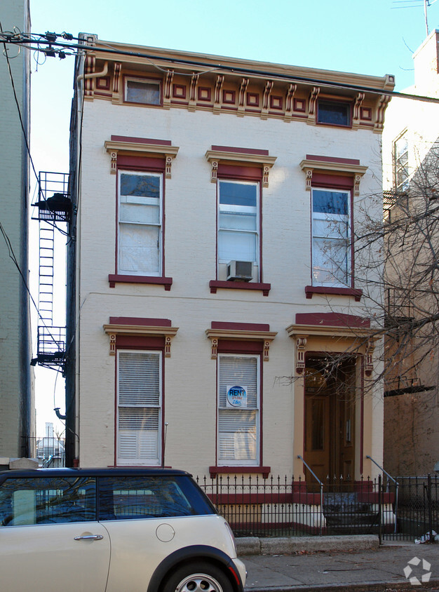
Experience Cincinnati living at 825 Dayton St. The 45214 location has so much to offer its residents. Here at this community, the leasing team is excited to help you find your new place. Be sure to come for a visit to view the available floorplans. Drop by 825 Dayton St today.
825 Dayton St is an apartment community located in Hamilton County and the 45214 ZIP Code. This area is served by the Cincinnati Public Schools attendance zone.
West End is a historic neighborhood about 1.5 miles northwest of Downtown Cincinnati. Once a manufacturing hub for beer, clothing, soap, and other goods, West End is an up-and-coming neighborhood undergoing revitalization. Several new developments are entering the neighborhood including a football stadium set to open in 2021. Along with housing several museums, West End rests next to one of the city’s most popular museums, the Cincinnati Museum Center at Union Terminal.
Combined with its charming historic buildings, West End is known for its strong sense of community. Community gardens and programs at the West End’s several recreation centers are just two ways locals connect. West End has rentals options for every budget in a variety of styles including apartments in renovated brick buildings. Proximity to downtown allows residents to have easy access to Cincinnati’s biggest attractions like the Duke Energy Convention Center and Paul Brown Stadium, home of Cincinnati Bengals.
Learn more about living in West EndCompare neighborhood and city base rent averages by bedroom.
| West End | Cincinnati, OH | |
|---|---|---|
| Studio | $839 | $1,069 |
| 1 Bedroom | $1,355 | $1,141 |
| 2 Bedrooms | $1,109 | $1,434 |
| 3 Bedrooms | $1,327 | $1,752 |
| Colleges & Universities | Distance | ||
|---|---|---|---|
| Colleges & Universities | Distance | ||
| Drive: | 6 min | 2.2 mi | |
| Drive: | 7 min | 2.6 mi | |
| Drive: | 8 min | 3.1 mi | |
| Drive: | 14 min | 5.4 mi |


Transportation options available in Cincinnati include Brewery District Station - Elm & Henry, located 0.6 mile from 825 Dayton St. 825 Dayton St is near Cincinnati/Northern Kentucky International, located 15.3 miles or 29 minutes away.
| Transit / Subway | Distance | ||
|---|---|---|---|
| Transit / Subway | Distance | ||
| Walk: | 11 min | 0.6 mi | |
| Walk: | 12 min | 0.6 mi | |
| Walk: | 13 min | 0.7 mi | |
| Walk: | 14 min | 0.8 mi | |
| Walk: | 16 min | 0.9 mi |
| Commuter Rail | Distance | ||
|---|---|---|---|
| Commuter Rail | Distance | ||
|
|
Drive: | 4 min | 1.2 mi |
| Airports | Distance | ||
|---|---|---|---|
| Airports | Distance | ||
|
Cincinnati/Northern Kentucky International
|
Drive: | 29 min | 15.3 mi |
Scores provided by
Traffic
-Airport
-Businesses
-Scores provided by
HowLoud What is a Sound Score Rating? A Sound Score Rating aggregates noise caused by vehicle traffic, airplane traffic and local sources. How It WorksTime and distance from 825 Dayton St.
| Shopping Centers | Distance | ||
|---|---|---|---|
| Shopping Centers | Distance | ||
| Walk: | 9 min | 0.5 mi | |
| Drive: | 5 min | 1.8 mi | |
| Drive: | 5 min | 2.1 mi |
| Parks and Recreation | Distance | ||
|---|---|---|---|
| Parks and Recreation | Distance | ||
|
Duke Energy Children's Museum
|
Drive: | 4 min | 1.2 mi |
|
OMNIMAX Theater
|
Drive: | 4 min | 1.2 mi |
|
Museum of Natural History and Science
|
Drive: | 4 min | 1.2 mi |
|
Cincinnati History Museum
|
Drive: | 4 min | 1.2 mi |
|
William H. Taft National Historic Site
|
Drive: | 5 min | 1.5 mi |
| Hospitals | Distance | ||
|---|---|---|---|
| Hospitals | Distance | ||
| Drive: | 5 min | 1.6 mi | |
| Drive: | 5 min | 2.6 mi | |
| Drive: | 7 min | 2.6 mi |
| Military Bases | Distance | ||
|---|---|---|---|
| Military Bases | Distance | ||
| Drive: | 69 min | 53.7 mi | |
| Drive: | 76 min | 58.8 mi | |
| Drive: | 78 min | 62.1 mi |
What Are Walk Score®, Transit Score®, and Bike Score® Ratings?
Walk Score® measures the walkability of any address. Transit Score® measures access to public transit. Bike Score® measures the bikeability of any address.
What is a Sound Score Rating?
A Sound Score Rating aggregates noise caused by vehicle traffic, airplane traffic and local sources.
825 Dayton St
Cincinnati, OH 45214


