

$3,200
/ Month
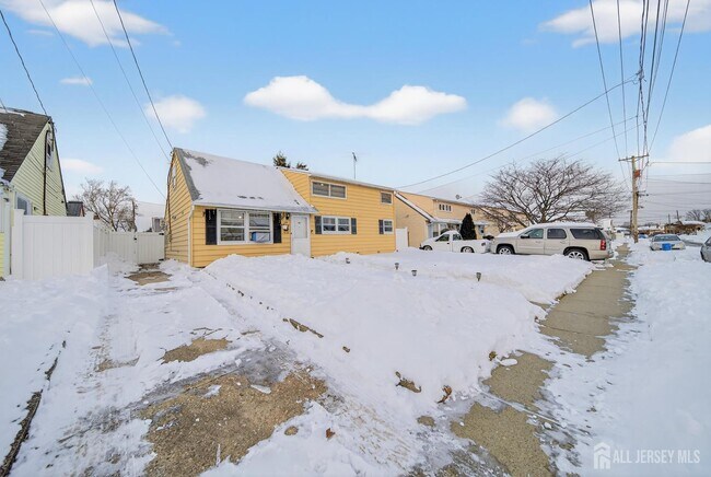
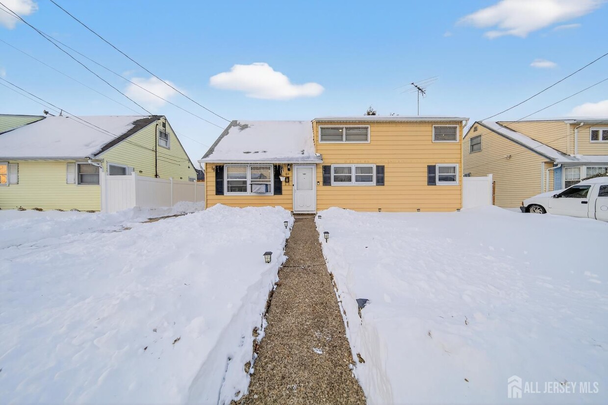
80 Poplar St
Carteret, NJ 07008
Today
|
Edit
Favorites
732-634-9100
-
Bedrooms
4
-
Bathrooms
2
-
Square Feet
1,584 sq ft
-
Available
Available Now
Highlights
- Room for Rent
- Hardwood Floors
- Vaulted Ceiling
80 Poplar St

Favorites
About This Home
12 Month Lease
,
Available Now
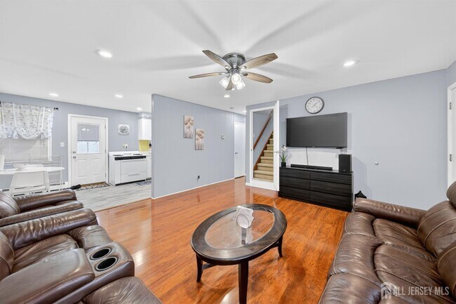
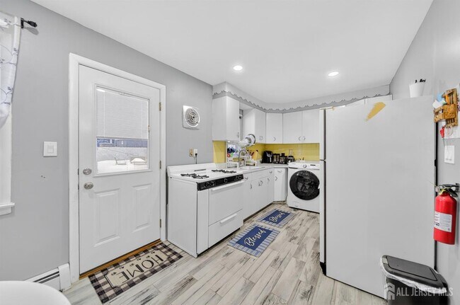
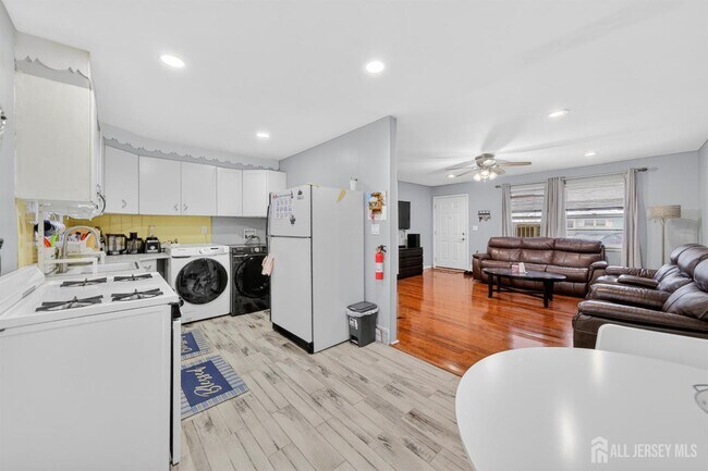
Spacious 4 bedroom,2 full bath home with a smart 2 level layout. The main level offers 3 bedrooms,1 full bath,and an open living,dining,and kitchen area. Upstairs features a loft sitting area and a private bedroom with an attached full bath,ideal as a primary suite or guest space. 2 car deep driveway adds everyday convenience.
80 Poplar St is a house located in Middlesex County and the 07008 ZIP Code. This area is served by the Carteret Public attendance zone.
* Price shown is base rent. Excludes user-selected optional fees and variable or usage-based fees and required charges due at or prior to move-in or at move-out. Price, availability, fees, and any applicable rent special are subject to change without notice.
* Square footage definitions vary. Displayed square footage is approximate.
House Features
Washer/Dryer
Air Conditioning
Hardwood Floors
Refrigerator
- Washer/Dryer
- Air Conditioning
- Ceiling Fans
- Kitchen
- Oven
- Range
- Refrigerator
- Hardwood Floors
- Tile Floors
- Vinyl Flooring
- Dining Room
- Vaulted Ceiling
Fees and Policies
Details
Lease Options
-
12 Months
Contact
- Listed by SUKHWINDER KAUR | J.J. ELEK REALTY CO.
- Phone Number
- Contact
-
Source
 CENTRAL JERSEY MULTIPLE LISTING SYSTEM, INC
The CENTRAL JERSEY MULTIPLE LISTING SYSTEM, INC does not warrant the accuracy, quality, reliability, suitability, completeness, usefulness or effectiveness of any information provided. The information being provided is for consumers' personal, non-commercial use and may not be used for any purpose other than to identify properties the consumer may be interested in purchasing or renting. Copyright 2026, CENTRAL JERSEY MULTIPLE LISTING SYSTEM, INC. All rights reserved. “The CENTRAL JERSEY MULTIPLE LISTING SYSTEM, INC retains all rights, title and interest in and to its trademarks, service marks and copyrighted material.
Location
Get Directions
Amenities
- Washer/Dryer
- Air Conditioning
- Ceiling Fans
- Kitchen
- Oven
- Range
- Refrigerator
- Hardwood Floors
- Tile Floors
- Vinyl Flooring
- Dining Room
- Vaulted Ceiling
Located directly across the Arthur Kill from Staten Island, Carteret was once part of the Woodbridge Township. It became the borough of Roosevelt in 1906 and was renamed Carteret in 1922. This popular community is bordered by the Rahway River to the north, Arthur Kill to the east, and the Ernest L. Oros Wildlife Preserve to the west. Due to its central location, the borough bills itself as the "Center of it All."
Residents enjoy a fantastic location and beautiful parks. Carteret Waterfront Park has a fishing pier and access to two hiking trails: Danielle's Garden Trail and the Waterfront Fitness Trail. Shopping in Carteret is plentiful -- the brick-paved sidewalks and outdoor cafes along Washington Avenue provide historic charm and locally-owned businesses, while the shops and restaurants along Roosevelt Avenue have a more modern feel. With just 22 miles to Manhattan, 10 miles to Newark, and 70 miles to Philadelphia, residents can easily commute to nearby cities.
Learn more about living in Carteret
Education
| Colleges & Universities | Distance | ||
|---|---|---|---|
| Colleges & Universities | Distance | ||
| Drive: | 16 min | 7.7 mi | |
| Drive: | 19 min | 9.3 mi | |
| Drive: | 20 min | 10.6 mi | |
| Drive: | 26 min | 11.1 mi |
80 Poplar St is within 16 minutes or 7.7 miles from Union County Coll., Elizabeth. It is also near Kean University and Union County College, Cranford.
Schools


Public Elementary School
Grades 5-6
553 Students
Attendance Zone
Public Elementary School
Grades PK-4
578 Students
Attendance Zone
Public High School
Grades 9-12
1,089 Students
Attendance Zone
Private Elementary, Middle & High School
40 Students
Nearby
Private Elementary School
Grades PK-5
Nearby
School data provided by
 The GreatSchools Rating helps parents compare schools within a state based on a variety of school quality indicators and provides a helpful picture of how effectively each school serves all of its students. Ratings are on a scale of 1 (below average) to 10 (above average) and can include test scores, college readiness, academic progress, advanced courses, equity, discipline and attendance data. We also advise parents to visit schools, consider other information on school performance and programs, and consider family needs as part of the school selection process.
View GreatSchools Rating Methodology
Data provided by GreatSchools.org © 2026. All rights reserved.
View GreatSchools Rating Methodology
Data provided by GreatSchools.org © 2026. All rights reserved.
Transportation options available in Carteret include 8Th Street Light Rail Station, located 12.2 miles from 80 Poplar St. 80 Poplar St is near Newark Liberty International, located 13.8 miles or 23 minutes away, and LaGuardia, located 31.1 miles or 52 minutes away.
| Transit / Subway | Distance | ||
|---|---|---|---|
| Transit / Subway | Distance | ||
| Drive: | 22 min | 12.2 mi | |
|
|
Drive: | 24 min | 13.4 mi |
|
|
Drive: | 23 min | 15.1 mi |
|
|
Drive: | 22 min | 15.1 mi |
| Commuter Rail | Distance | ||
|---|---|---|---|
| Commuter Rail | Distance | ||
|
|
Drive: | 7 min | 3.2 mi |
|
|
Drive: | 11 min | 4.4 mi |
|
|
Drive: | 11 min | 4.7 mi |
|
|
Drive: | 14 min | 7.0 mi |
|
|
Drive: | 20 min | 9.7 mi |
| Airports | Distance | ||
|---|---|---|---|
| Airports | Distance | ||
|
Newark Liberty International
|
Drive: | 23 min | 13.8 mi |
|
LaGuardia
|
Drive: | 52 min | 31.1 mi |
Time and distance from 80 Poplar St.
| Shopping Centers | Distance | ||
|---|---|---|---|
| Shopping Centers | Distance | ||
| Drive: | 4 min | 1.3 mi | |
| Drive: | 5 min | 1.5 mi | |
| Drive: | 5 min | 1.9 mi |
80 Poplar St has 3 shopping centers within 1.9 miles, which is about a 5-minute drive. The miles and minutes will be for the farthest away property.
| Parks and Recreation | Distance | ||
|---|---|---|---|
| Parks and Recreation | Distance | ||
|
Liberty State Park
|
Drive: | 6 min | 2.3 mi |
|
Hawk Rise Sanctuary
|
Drive: | 13 min | 5.6 mi |
|
Bloomingdale Park
|
Drive: | 18 min | 8.7 mi |
|
Clay Pit Ponds State Park Preserve
|
Drive: | 21 min | 9.2 mi |
|
Freshkills Park
|
Drive: | 23 min | 12.1 mi |
80 Poplar St has 5 parks within 12.1 miles, including Liberty State Park, Hawk Rise Sanctuary, and Bloomingdale Park.
| Hospitals | Distance | ||
|---|---|---|---|
| Hospitals | Distance | ||
| Drive: | 13 min | 5.6 mi | |
| Drive: | 13 min | 6.2 mi | |
| Drive: | 18 min | 7.9 mi |
80 Poplar St has 3 hospitals within 7.9 miles, the nearest is Robert Wood Johnson University Hospital at Rahway which is 5.6 miles away and a 13 minute drive.
| Military Bases | Distance | ||
|---|---|---|---|
| Military Bases | Distance | ||
| Drive: | 21 min | 8.6 mi | |
| Drive: | 24 min | 9.4 mi | |
| Drive: | 29 min | 15.2 mi |
80 Poplar St has 3 military bases within 15.2 miles, the nearest is Ash Brook Reservation which is 8.6 miles away and a 21 minute drive.
You May Also Like
How do I access Social Services in New Jersey?
Statewide service is free, confidential, multilingual and always open. Three easy ways to reach Social Services in NJ: Dial 2-1-1; text your zip code to 898-211; or chat at https://www.nj211.org
Similar Rentals Nearby


What Are Walk Score®, Transit Score®, and Bike Score® Ratings?
Walk Score® measures the walkability of any address. Transit Score® measures access to public transit. Bike Score® measures the bikeability of any address.
What is a Sound Score Rating?
A Sound Score Rating aggregates noise caused by vehicle traffic, airplane traffic and local sources
80 Poplar St
Carteret, NJ 07008