
Isle House
39 Bruton St,
San Francisco, CA 94130
$3,050 - $6,998
Studio - 3 Beds
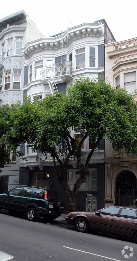

*Move in special: now offering 4 weeks free for a limited time!* 736 Leavenworth Street is a nine unit building in Lower Nob Hill that is walking distance to San Francisco’s world-famous Cable Cars and the premier shopping experience that Union Square has to offer. The local Trader Joes is also only a few blocks away, as is the popular Mr. Holmes Bakehouse. We can smell the oven baked croissants from here.
736 Leavenworth is an apartment community located in San Francisco County and the 94109 ZIP Code. This area is served by the San Francisco Unified attendance zone.
Hardwood Floors
Refrigerator
Window Coverings
Oven
San Francisco’s Lower Nob Hill sits in the heart of Downtown, offering residents a premier location in one of California’s most popular cities. Situated between Union Square and US-101, locals can easily travel through the city, but why leave when there are so many conveniences right in this neighborhood? Union Square is San Francisco’s expansive and famous shopping plaza known for its upscale shops, restaurants, hotels, and nightlife spots.
Lower Nob’s light rail and bus stations are abundant, making commuting as easy as ever. This neighborhood is a great place for job opportunities due to the vast number of businesses in the area. Lower Nob is home to Saint Francis Memorial Hospital, the Masonic, and Dragon’s Gate, a landmark arch that’s the iconic gateway to Chinatown, Lower Nob’s neighbor. This neighborhood features an array of upscale apartments, houses, and condos that will fit any renter’s preferences and style.
Learn more about living in Lower Nob| Colleges & Universities | Distance | ||
|---|---|---|---|
| Colleges & Universities | Distance | ||
| Walk: | 3 min | 0.2 mi | |
| Drive: | 4 min | 1.3 mi | |
| Drive: | 5 min | 1.4 mi | |
| Drive: | 7 min | 2.4 mi |


Transportation options available in San Francisco include California And Leavenworth, located 0.2 mile from 736 Leavenworth. 736 Leavenworth is near San Francisco International, located 14.8 miles or 24 minutes away, and Metro Oakland International, located 19.7 miles or 31 minutes away.
| Transit / Subway | Distance | ||
|---|---|---|---|
| Transit / Subway | Distance | ||
|
|
Walk: | 4 min | 0.2 mi |
|
|
Walk: | 6 min | 0.3 mi |
|
|
Walk: | 6 min | 0.3 mi |
| Walk: | 7 min | 0.4 mi | |
|
|
Walk: | 7 min | 0.4 mi |
| Commuter Rail | Distance | ||
|---|---|---|---|
| Commuter Rail | Distance | ||
| Drive: | 5 min | 1.8 mi | |
| Drive: | 5 min | 1.8 mi | |
| Drive: | 7 min | 3.3 mi | |
| Drive: | 7 min | 3.3 mi | |
| Drive: | 12 min | 6.9 mi |
| Airports | Distance | ||
|---|---|---|---|
| Airports | Distance | ||
|
San Francisco International
|
Drive: | 24 min | 14.8 mi |
|
Metro Oakland International
|
Drive: | 31 min | 19.7 mi |
Time and distance from 736 Leavenworth.
| Shopping Centers | Distance | ||
|---|---|---|---|
| Shopping Centers | Distance | ||
| Walk: | 8 min | 0.4 mi | |
| Walk: | 13 min | 0.7 mi | |
| Drive: | 4 min | 1.3 mi |
| Parks and Recreation | Distance | ||
|---|---|---|---|
| Parks and Recreation | Distance | ||
|
Children's Creativity Museum
|
Drive: | 3 min | 1.2 mi |
|
San Francisco Maritime National Historical Park
|
Drive: | 4 min | 1.5 mi |
|
Aquarium of The Bay
|
Drive: | 6 min | 2.1 mi |
|
Buena Vista Park
|
Drive: | 9 min | 2.8 mi |
|
Randall Museum
|
Drive: | 10 min | 3.1 mi |
| Hospitals | Distance | ||
|---|---|---|---|
| Hospitals | Distance | ||
| Walk: | 4 min | 0.2 mi | |
| Walk: | 8 min | 0.4 mi | |
| Walk: | 16 min | 0.9 mi |
| Military Bases | Distance | ||
|---|---|---|---|
| Military Bases | Distance | ||
| Drive: | 15 min | 5.2 mi | |
| Drive: | 13 min | 5.8 mi | |
| Drive: | 27 min | 14.3 mi |
What Are Walk Score®, Transit Score®, and Bike Score® Ratings?
Walk Score® measures the walkability of any address. Transit Score® measures access to public transit. Bike Score® measures the bikeability of any address.
What is a Sound Score Rating?
A Sound Score Rating aggregates noise caused by vehicle traffic, airplane traffic and local sources
736 Leavenworth St
San Francisco, CA 94109


