679 Levering Ave
679 Levering Ave,
Los Angeles,
CA
90024
2 Weeks Ago
Favorites
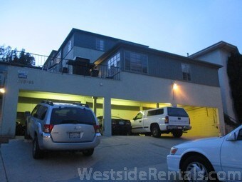
679 Levering Ave

Favorites
Check Back Soon for Upcoming Availability
About 679 Levering Ave Los Angeles, CA 90024
2 Beds, 1 Bath in private garden-like setting Not Specified units 1-car Parking Available. Private rear entrance, No laundry on premises, very bright and cheerful unit is a multi-family home in Los Angeles, CA 90024. This 6,715 square foot multi-family home sits on a 9,906 square foot lot and features 11 bedrooms and 8 bathrooms. This property was built in 1948. Nearby schools include UCLA Campus, California Nanosystems Institute and Marymount High School Los Angeles. The closest grocery stores are 99c store, Whole Foods Market and Whole Foods Market Gayley ave. Nearby coffee shops include De Neve Grab 'n Go, Dina's Cafe and Mon Amour Cafe. Nearby restaurants include Westwood Pizzeria | Order food Online | Clorder, Lucia's (westwood pizzeria) and BBQ Chicken. 679 Levering Ave is near University of California - Los Angeles, Center for Health Sciences Plaza and Occidental Petroleum Headquarters. There are good bike lanes and the terrain has some hills. bikeable, there is some bike infrastructure.
679 Levering Ave is an apartment community located in Los Angeles County and the 90024 ZIP Code.
Apartment Features
- Refrigerator
Location
Get Directions
Home to UCLA, Westwood lies on the west side of the city and is considered to be one of Los Angeles’ premier neighborhoods. Bordered by Beverly Hills, Bel Air, Brentwood, and Century City, multimillion dollar homes populate the landscape and students pay a premium to rent near campus.
The university itself serves as a major cultural center for the community, including on-campus attractions (such as the Fowler Museum and the Franklin D. Murphy Sculpture Garden) and university-affiliated venues off-campus (The Hammer Museum, the Geffen Playhouse), as well as the presence of thousands of students and faculty members throughout the neighborhood.
Directly south of campus, Westwood Village is a historic shopping district that features blocks of restaurants and businesses catering to both students and the neighborhood’s larger workforce. Many prominent corporations and law offices are found along Wilshire Boulevard, one of the busiest east-west transit corridors across the city.
Learn more about living in WestwoodBelow are rent ranges for similar nearby apartments
| Beds | Average Size | Lowest | Typical | Premium |
|---|---|---|---|---|
| Studio Studio Studio | 364-372 Sq Ft | $1,295 | $2,277 | $9,999 |
| 1 Bed 1 Bed 1 Bed | 674-676 Sq Ft | $955 | $3,004 | $6,950 |
| 2 Beds 2 Beds 2 Beds | 1118-1123 Sq Ft | $995 | $4,565 | $17,000 |
| 3 Beds 3 Beds 3 Beds | 1586-1611 Sq Ft | $1,795 | $6,736 | $16,750 |
| 4 Beds 4 Beds 4 Beds | 1488-1572 Sq Ft | $1,000 | $4,880 | $85,000 |
Amenities
- Refrigerator
Education
| Colleges & Universities | Distance | ||
|---|---|---|---|
| Colleges & Universities | Distance | ||
| Walk: | 13 min | 0.7 mi | |
| Drive: | 9 min | 3.5 mi | |
| Drive: | 14 min | 4.2 mi | |
| Drive: | 10 min | 4.6 mi |
679 Levering Ave is within 13 minutes or 0.7 mile from UCLA. It is also near Santa Monica Coll., Academy and Mount St. Mary's Coll, Chalon.
Transportation options available in Los Angeles include Expo / Sepulveda Station, located 2.7 miles from 679 Levering Ave. 679 Levering Ave is near Los Angeles International, located 11.0 miles or 18 minutes away, and Bob Hope, located 16.8 miles or 27 minutes away.
| Transit / Subway | Distance | ||
|---|---|---|---|
| Transit / Subway | Distance | ||
| Drive: | 6 min | 2.7 mi | |
|
|
Drive: | 8 min | 2.8 mi |
|
|
Drive: | 8 min | 4.3 mi |
|
|
Drive: | 11 min | 4.3 mi |
|
|
Drive: | 10 min | 5.5 mi |
| Commuter Rail | Distance | ||
|---|---|---|---|
| Commuter Rail | Distance | ||
|
|
Drive: | 20 min | 13.1 mi |
|
|
Drive: | 29 min | 14.5 mi |
|
|
Drive: | 27 min | 16.7 mi |
|
|
Drive: | 26 min | 17.6 mi |
| Drive: | 28 min | 17.6 mi |
| Airports | Distance | ||
|---|---|---|---|
| Airports | Distance | ||
|
Los Angeles International
|
Drive: | 18 min | 11.0 mi |
|
Bob Hope
|
Drive: | 27 min | 16.8 mi |
Time and distance from 679 Levering Ave.
| Shopping Centers | Distance | ||
|---|---|---|---|
| Shopping Centers | Distance | ||
| Walk: | 10 min | 0.6 mi | |
| Walk: | 11 min | 0.6 mi | |
| Walk: | 12 min | 0.6 mi |
679 Levering Ave has 3 shopping centers within 0.6 mile, which is about a 12-minute walk. The miles and minutes will be for the farthest away property.
| Parks and Recreation | Distance | ||
|---|---|---|---|
| Parks and Recreation | Distance | ||
|
Mathias Botanical Garden
|
Walk: | 14 min | 0.8 mi |
|
Hannah Carter Japanese Garden
|
Drive: | 6 min | 2.4 mi |
|
Virginia Robinson Gardens
|
Drive: | 11 min | 4.2 mi |
|
Will Rogers State Historic Park
|
Drive: | 18 min | 6.7 mi |
|
Franklin Canyon Park
|
Drive: | 20 min | 7.1 mi |
679 Levering Ave has 5 parks within 7.1 miles, including Mathias Botanical Garden, Hannah Carter Japanese Garden, and Virginia Robinson Gardens.
| Hospitals | Distance | ||
|---|---|---|---|
| Hospitals | Distance | ||
| Walk: | 11 min | 0.6 mi | |
| Walk: | 12 min | 0.6 mi | |
| Drive: | 9 min | 3.6 mi |
679 Levering Ave has 3 hospitals within 3.6 miles, the nearest is Ronald Reagan UCLA Medical Center which is 0.6 mile away and a 11 minute walk.
| Military Bases | Distance | ||
|---|---|---|---|
| Military Bases | Distance | ||
| Drive: | 19 min | 13.6 mi |
679 Levering Ave is 13.6 miles and a 19 minute drive from Los Angeles Air Force Base.
You May Also Like
Similar Rentals Nearby


 - AVA Burbank")


What Are Walk Score®, Transit Score®, and Bike Score® Ratings?
Walk Score® measures the walkability of any address. Transit Score® measures access to public transit. Bike Score® measures the bikeability of any address.
What is a Sound Score Rating?
A Sound Score Rating aggregates noise caused by vehicle traffic, airplane traffic and local sources