
$2,100
/ Month
670 St Marks Ave
Brooklyn, NY 11216
2 Weeks Ago
|
Edit
Favorites
670 St Marks Ave

Favorites
Check Back Soon for Upcoming Availability
| Beds | Baths | Average SF |
|---|---|---|
| 1 Bedroom 1 Bedroom 1 Br | 1 Bath 1 Bath 1 Ba | 900 SF |
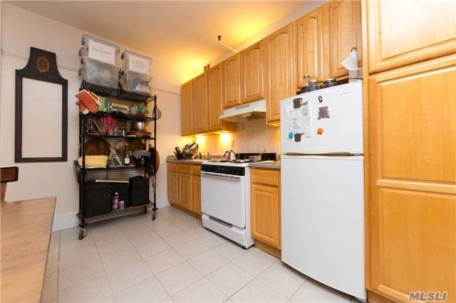
About This Property
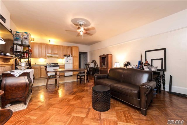
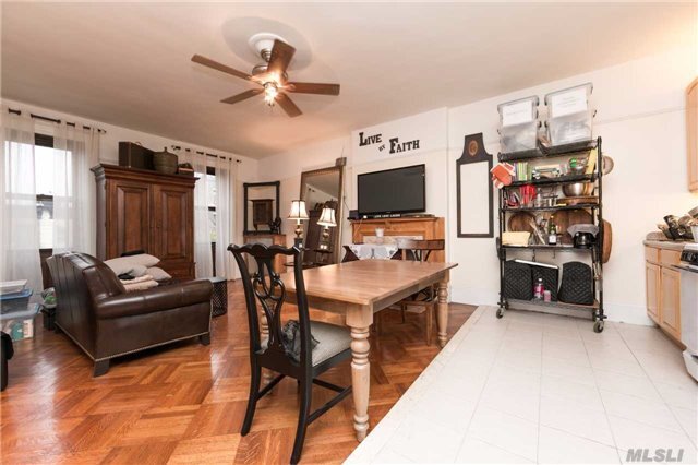
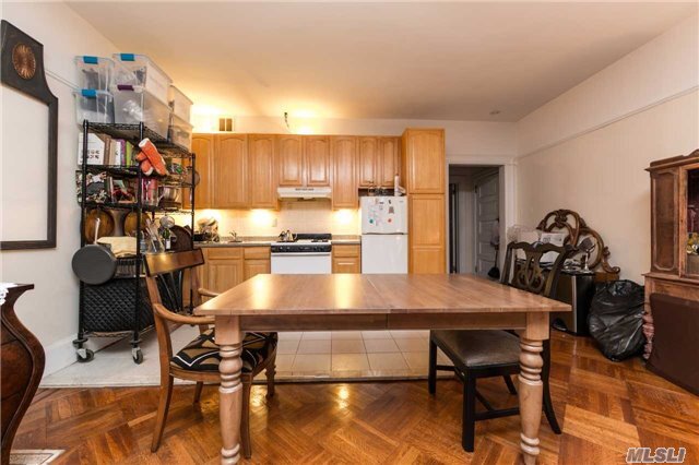
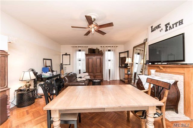
Charming Super Large 1 Bedroom Apartment In A Mansion - Located On A Beautiful Tree Lined Block Of Crown Heights. Walk In Closet Space. Beautiful Original Details, Including Parquet Floors And Two Non-Working Fireplace Mantles. Heat & Hot Water Included. Near To Brooklyn Museum, Botanical Garden, Brooklyn Library And Prospect Park. Close To Shopping And Public Trans.
670 St Marks Ave is a townhome located in Kings County and the 11216 ZIP Code.
Location
Get Directions
Crown Heights is a central neighborhood in New York’s bustling borough of Brooklyn. Just minutes from the Brooklyn Botanic Garden and the Brooklyn Museum, Crown Heights’ residents have convenient access to some of Brooklyn’s greatest attractions.
Take the whole family to the Brooklyn Children’s Museum to explore the world’s first children’s museum, opened in 1899. Many community parks are available in the neighborhood, such as St. Johns Park, equipped with ball fields, basketball courts, and a recreation center. Enjoy a handcrafted burger paired with a craft beer at Boeuf & Bun, an upbeat local spot in Crown Heights. There’s a variety of apartments and condos available for rent in this central Brooklyn neighborhood.
Learn more about living in Crown HeightsBelow are rent ranges for similar nearby apartments
| Beds | Average Size | Lowest | Typical | Premium |
|---|---|---|---|---|
| Studio Studio Studio | 655-673 Sq Ft | $2,200 | $3,652 | $5,500 |
| 1 Bed 1 Bed 1 Bed | 1543 Sq Ft | $1,750 | $3,168 | $4,693 |
| 2 Beds 2 Beds 2 Beds | 917 Sq Ft | $2,030 | $4,006 | $6,411 |
| 3 Beds 3 Beds 3 Beds | 1153 Sq Ft | $1,260 | $3,156 | $5,400 |
| 4 Beds 4 Beds 4 Beds | 761 Sq Ft | $1,080 | $2,282 | $12,000 |
Education
| Colleges & Universities | Distance | ||
|---|---|---|---|
| Colleges & Universities | Distance | ||
| Walk: | 15 min | 0.8 mi | |
| Drive: | 6 min | 1.8 mi | |
| Drive: | 5 min | 2.0 mi | |
| Drive: | 7 min | 2.5 mi |
670 St Marks Ave is within 15 minutes or 0.8 mile from Medgar Evers College, CUNY. It is also near Saint Joseph's Coll, Brooklyn and Pratt Institute.
Transportation options available in Brooklyn include Nostrand Avenue (A,C Line), located 0.4 mile from 670 St Marks Ave. 670 St Marks Ave is near LaGuardia, located 10.8 miles or 21 minutes away, and John F Kennedy International, located 12.2 miles or 22 minutes away.
| Transit / Subway | Distance | ||
|---|---|---|---|
| Transit / Subway | Distance | ||
|
|
Walk: | 8 min | 0.4 mi |
|
|
Walk: | 8 min | 0.4 mi |
|
|
Walk: | 8 min | 0.4 mi |
|
|
Walk: | 11 min | 0.6 mi |
|
|
Walk: | 12 min | 0.6 mi |
| Commuter Rail | Distance | ||
|---|---|---|---|
| Commuter Rail | Distance | ||
|
|
Walk: | 7 min | 0.4 mi |
|
|
Drive: | 6 min | 1.8 mi |
|
|
Drive: | 8 min | 3.1 mi |
|
|
Drive: | 16 min | 6.4 mi |
|
|
Drive: | 17 min | 6.7 mi |
| Airports | Distance | ||
|---|---|---|---|
| Airports | Distance | ||
|
LaGuardia
|
Drive: | 21 min | 10.8 mi |
|
John F Kennedy International
|
Drive: | 22 min | 12.2 mi |
Time and distance from 670 St Marks Ave.
| Shopping Centers | Distance | ||
|---|---|---|---|
| Shopping Centers | Distance | ||
| Drive: | 6 min | 2.0 mi | |
| Drive: | 6 min | 2.1 mi |
670 St Marks Ave has 2 shopping centers within 2.1 miles, which is about a 6-minute drive. The miles and minutes will be for the farthest away property.
| Parks and Recreation | Distance | ||
|---|---|---|---|
| Parks and Recreation | Distance | ||
|
Brooklyn Children's Museum
|
Walk: | 7 min | 0.4 mi |
|
Crispus Attucks Playground
|
Walk: | 14 min | 0.8 mi |
|
St. John's Park
|
Drive: | 5 min | 1.2 mi |
|
Brooklyn Botanic Garden
|
Drive: | 4 min | 1.4 mi |
|
Hattie Carthan Garden
|
Drive: | 5 min | 1.7 mi |
670 St Marks Ave has 5 parks within 1.7 miles, including Brooklyn Children's Museum, Crispus Attucks Playground, and St. John's Park.
| Hospitals | Distance | ||
|---|---|---|---|
| Hospitals | Distance | ||
| Drive: | 4 min | 1.1 mi | |
| Drive: | 6 min | 1.8 mi | |
| Drive: | 6 min | 1.8 mi |
670 St Marks Ave has 3 hospitals within 1.8 miles, the nearest is Interfaith Medical Center which is 1.1 miles away and a 4 minute drive.
| Military Bases | Distance | ||
|---|---|---|---|
| Military Bases | Distance | ||
| Drive: | 18 min | 7.3 mi | |
| Drive: | 19 min | 7.7 mi |
670 St Marks Ave is 7.3 miles from Governors Island Support Center, and is convenient to other military bases, including Fort Hamilton.
You May Also Like
Similar Rentals Nearby


What Are Walk Score®, Transit Score®, and Bike Score® Ratings?
Walk Score® measures the walkability of any address. Transit Score® measures access to public transit. Bike Score® measures the bikeability of any address.
What is a Sound Score Rating?
A Sound Score Rating aggregates noise caused by vehicle traffic, airplane traffic and local sources

670 St Marks Ave
Brooklyn, NY 11216